GPS SightFinder looks for sights, landmarks and other interesting places close to your current location. Descriptive search results with thumbnail images link to the corresponding Wikipedia articles for detailed up-to-date information.
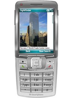
GPS SightFinder is a Windows Mobile application for Smartphones and PocketPCs with built-in GPS or a connected Bluetooth GPS device. Based on the location reported by your GPS device it looks for all kinds of geographic objects: towns and villages, rivers and lakes, buildings, tourist sights and many more.
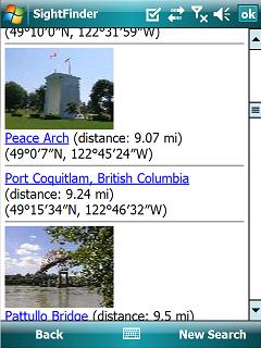
Search results are comfortably presented in a list along with their distance from your location and a short summary. From there you can start browsing referenced Wikipedia articles for much more information on the sight of your choice.
Key features
GPS SightFinder works worldwide.
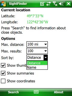
Search results can be sorted by name or by distance from your current location.
Thumbnail images are available for many sights and are diplayed with your search results.
GPS SightFinder is customizable: You can configure how and how many search results are displayed.
Since GPS SightFinder fetches text and pictures over the Internet from Wikipedia articles all information is always up-to-date. New geo-referenced articles are constantly added by the community.
Add geographical coordinates to your favorite Wikipedia article on local sights and they will soon appear in GPS SightFinder when you visit them. Impress your visiting friends with your knowledge on-site.
GPS SightFinder is the ideal guide for world traveling or just short trips to popular places.
Travel light and leave your books at home, all you need ist your mobile phone and GPS SightFinder.
Like it? Share with your friends!
If you got an error while installing Themes, Software or Games, please, read FAQ.
Supported operating systems:
Windows Mobile 5.0 Smartphone, Windows Mobile 6 Standard, Windows Mobile 6.1 Standard
Other Software by developer «Skylab Mobilesystems Ltd.»:
MobileTracker MobileTracker
The tracklog application for mobile devices!
Records a tracklog.
Elevation can be tracked.
Configurable timespan between positions.
Extensive statistical information
Spot for BlackBerry Spot combines your BlackBerry and Bluetooth GPS receiver into the most powerful positioning tool
GPS Waypoint Manager - Free BETA GPS Waypoint Manager - Free BETA - The GPS Waypoint Manager for BlackBerry® Smartphones is a comprehensive tool for managing waypoints and points of interests (POI) right on your phone. By using the GPS in your device, your can accurately pin-point your location and map out other points as well. You also have the ability to import/export .kmz and
Spot Spot - Geocaching, hiking, biking, outdoor activities. Combine the power of GPS with worldwide maps and a flexible waypoint management. Orientation and routing enables you to find interesting places, store and share them with others
Spot for BlackBerry (OS 4.2) Spot combines your BlackBerry and Bluetooth GPS receiver into the most powerful positioning tool
LocalWeather LocalWeather is an application for Windows Mobile Smartphones and PocketPCs providing location-based weather information. It retrieves the current location from a GPS receiver, looks up the nearest weather station and fetches information on the current weather conditions from the Internet
ContactMapper Geocodes your contacts from the address book and shows them on a satellite or topographic map. The 2-click-on-map-application!
TopoExplorer for Touch Screen Devices ONLY TopoExplorer for Touch Screen Devices ONLY
Features | Free Download
With TopoExplorer you will discover your surroundings on topographic maps even in remote areas assisted by GPS and without the need of the wireless network connection
TopoExplorer for Non-Touch Screen Devices ONLY TopoExplorer for Non-Touch Screen Devices ONLY
Features | Free Download
With TopoExplorer you will discover your surroundings on topographic maps even in remote areas assisted by GPS and without the need of the wireless network connection


")


