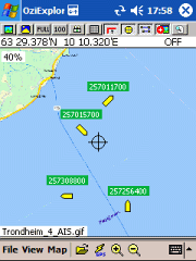
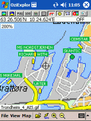
AIS2OZI - AIS2OZI tracks ship positions. It is a logger/decoder/plotter for PocketPC.
Ship positions are plotted directly in OziExplorer Download AIS2OZI (Make backup of Shiplist.txt when reinstalling.)
Decodes AIVDM sentences of types 1, 2, 3 and 5, i.e. position reports for class A shipborne equipment plus vessel information.
Like it? Share with your friends!
If you got an error while installing Themes, Software or Games, please, read FAQ.
Supported operating systems:
Windows Mobile 5.0, Windows Mobile 6 Classic, Windows Mobile 6 Professional, Windows Mobile 6.1 Classic, Windows Mobile 6.1 Professional, Windows Mobile 6.5 Professional
Similar Software:
GPS.Friend GPS.Friend - This is user-friendly program,
allows you, with just two touches of your phone:
- get and review your current geographic location
- request someone's phone to give you his/her location
- review on the map your and someone's location.
You needn't know GPS, you needn't learn too much, about this program
RulerGPSer RulerGPSer - RulerGPSer uses the GPS on your PocketPC to view and download GPS marked satellite camera pictures and calculates distance between two points specified by the latitude/longitude of your GPS using "The Vincenty inverse formula for ellipsoids." (accuracy to within 0.5mm, or 0.000015")
This program requires that you have both the 'BeanDLL
GPSPOIer GPSPOIer can be used to create GPS tagged POI points with custom names
PictureGPSed PictureGPSed - PictureGPSed checks the camera storage folder for new pictures/videos and when detected places the current GPS tag at the end of the image/video and sends it via email with a Google.com map link. You can also view the images via a distance file viewer. You can also view and download a map of the pictures from Google.com
LapLogger GPS (Pocket PC) LapLogger GPS - If you have a Bluetooth GPS and a PDA the sample module will grab the coordinates and render a quick map using a Web map. Your PDA needs internet access. A helpful tool in case you switched cars and need a quick map of your current location. Windows Mobile version has support for regular serial port, internal GPS and Bluetooth GPS
QuickGPS Lite QuickGPS Lite can speed up the time for determining your GPS position by downloading the latest satellite data via an Internet connection (such as GPRS, ActiveSync, etc.).
For quickest connection use:
1. Mod Driver
2. QuickGPS Lite
3. GPS Test
It takes around 10 seconds from cold start to get 9 satellites and have a stable connection
PoliceGPSer PoliceGPSer - PoliceGPSer converts the PocketPC into a GPS locator and reporter device. Select the update interval and the program will send the GPS location of the device to a FTP server at the interval. You can view the GPS of all GPS devices with the PocketPC PoliceGPSes.
This program requires that you have both the 'BeanDLL
GPSSMSerer GPSSMSerer uses the GPS on your PocketPC to find your latitude/longitude/altitude and speed and creates a single blank SMS template. When the program gets its first lock then it creates an SMS with your GPS update location and a link to the Google.com mobile online street map
GPSWM65Mapping GPSWM65Mapping - GPSWM65Mapping is a full featured map downloader that uses GPS. You can enter the lat/long coordinates or use your current GPS location to download a map. You can download in GIF, PNG or JPEG format. The app has several options to customize the map. The map service is provided by Google
Pocket PC Geocaching Tools Pocket PC Geocaching Tools - Many tools in one program to help you while you are geocaching.
What's included?
* Open GSAK databases directly
* HTML view
* Field Notes
* Hint decoder and decryption
* Several coordinate functions
* Solver
* Transformer (Text to Digits, etc
Other Software by developer «Frank Dahlslett»:
not found
Comments on AIS2OZI:
Comments not found
If you noted an error or download link is broken, please, report it via this page or use comments.
AIS2OZI is compatible with your device Honeywell 99EX Mobile Computer


")


