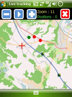
Mobbyway - Based on both internet mobile technologies and GPS, Mobbyway allows you to know easily, at any time, your relatives’ exact position on a map if they have accepted it and if they are connected to the network.
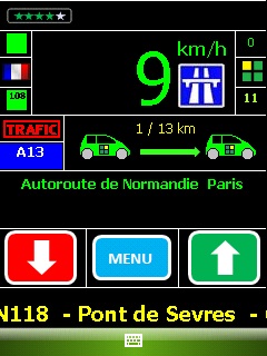
Mobbyway is also a help on the road network with a local alert system of a dangerous zone which is carried out with the network of members. Finally, Mobbyway will reference all the fixed radars in the countries where it is used and Mobbyway will indicate them to you.
Mobbyway was developed to allow:
- you to stay connected with your relatives wherever they are.
- your relatives to follow you visually and in real time.
- you to go back at any time to a place where you have already been on a specific date.
- you to travel safely on the road network thanks to the network members: The Mobbynautes.
- you to have a part in the world cartography OpenStreet Map
Like it? Share with your friends!
If you got an error while installing Themes, Software or Games, please, read FAQ.
Supported operating systems:
Windows Mobile 6 Classic, Windows Mobile 6 Professional, Windows Mobile 6.1 Classic, Windows Mobile 6.1 Professional, Windows Mobile 6.5 Professional
Similar Software:
GPSmeter Do you still use your GPS device for navigating only?
Turn your Pocket PC into a high precision metering machine using your GPS receiver! With MASPware GPSmeter you can measure short and long distances (beeline or routelength), altitude differences, timespans, average values and min-max-values using an internal or external GPS receiver
FON Access Points for Thailand FON Access Points for Thailand - FON offers you a new Points of Interest service (POIs). This allows you to download FONspots directly to your navigation device.
What does that mean? You can download a Points of Interest file directly to your navigation device
HotelGPSer HotelGPSer is a quick way to find your hotel/motel via GPS. Start the GPS and the program will display your current location
amAze (LG) AmAze is a first of its kind free navigation and local search service. It is free to download and use and it contains wide coverage of maps including aerial photo in Europe, North America, Australia and parts of Asia and Africa
DrinkGoogler DrinkGoogler uses the GPS on your PocketPC to find the 50 closest local bars sorted via GPS distance. Tap the button to start the GPS and when you get a lock tap on it to view the list of local bars. You can also dial the bar. The GPS maps and business search service is provided by Google
FON Access Points for Jordan FON Access Points for Jordan - FON offers you a new Points of Interest service (POIs). This allows you to download FONspots directly to your navigation device.
What does that mean? You can download a Points of Interest file directly to your navigation device
Navigation BE-ON-ROAD UK and Eire Q2/2011 Navigation BE-ON-ROAD UK and Eire Q2/2011 - The new major version of be-on-road presents new features and is based on new platform which brings high level of reliability, portability and speed on almost any kind of device. The new be-on-road brings high value voice guided door-to-door navigation
MapWM Record GPS data with your Windows Mobile device
BlueWave GPS Displays GPS navigational information for boating
Other Software by developer «Mobbyway»:
Mobbyway Mobbyway based on both internet mobile technologies and GPS, Mobbyway allows you to know easily, at any time, your relatives’ exact position on a map if they have accepted it and if they are connected to the network.Mobbyway is also a help on the road network with a local alert system of a dangerous zone which is carried out with the network of members


")
")


")


