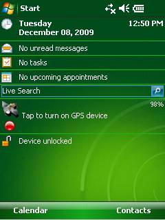
GPS2day is a today screen plug-in showing your current GPS coordinates, speed, satellite info, etc... Languages: English, Czech, Dutch, French, German, Hungarian, Italian, Japanese, Polish, Russian, Spanish.
Currently GPS2day program works as GPS informer. It supports both metric and U.S. (Imperial) units and shows a various types of information for users, such as:
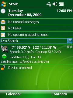
Current geographical coordinates (latitude, longitude);
Course and speed;
Some information about satellites and fix type;
Altitude followed by the fix 3D value;
Exact current date and time from the satellite atomic clock;
And battery life state which is important when you using GPS device.
What's New in This Release:
· Translation to Japanese was added
Like it? Share with your friends!
If you got an error while installing Themes, Software or Games, please, read FAQ.
Supported operating systems:
Windows Mobile 5.0, Windows Mobile 6 Classic, Windows Mobile 6 Professional, Windows Mobile 6.1 Classic, Windows Mobile 6.1 Professional, Windows Mobile 6.5 Professional
Similar Software:
SportsGPSes SportsGPSes - SportsGPSes can be used to view all of the players using the PocketPC SportsGPSer. The program downloads the GPS of all players and displays them on a customized map from Google.com.
This program requires that you have both the 'BeanDLL.dll' file ** and ** the runtime files for Visual Basic on your PocketPC computer
FON Access Points for Estonia FON Access Points for Estonia - FON offers you a new Points of Interest service (POIs). This allows you to download FONspots directly to your navigation device.
What does that mean? You can download a Points of Interest file directly to your navigation device
GPS Tuner Essentials Full Version with Central Europe Basic Map Content GPS Tuner Essentials Full Version with Central Europe Basic Map Content is designed specifically for off-road use: its large buttons, selectable tool window size, multiple Compass views and the built-in Tele Atlas map makes it extremely user-friendly and reliable
TravelReaderer TravelReaderer - TravelReaderer uses the GPS on your PocketPC to find your current latitude/longitude and says the readings in a computer voice. You can also view and download a map of your current position from the Google.com map service. You can customize the maps via the options setting in the toolbar.
This program requires that you have both the 'BeanDLL
PoliceGoogler PoliceGoogler uses the GPS on your PocketPC to find the 50 closest police services sorted via GPS distance. Tap the button to start the GPS and when you get a lock tap on it to view the list of local police services. You can also dial the numbers. The GPS maps and pig search service is provided by Google
SmartProtect SmartProtect helps you track and recover your phone once stolen or lost.
Features includes:
1. A Thief or Lost Prevention Software with SMS Auto-Responder and GPS Capability created for Windows Mobile Devices.
2
TextGPSs TextGPSs - TextGPSs can be used to make text notes with a GPS tag as the text file name and view the distance in meters of each text file in distance order via GPS. You can store your files on the storage card. You can also view the text entries with Google maps.
This program requires that you have both the 'BeanDLL
MapGoogler MapGoogler uses the GPS on your PocketPC to find your current latitude/longitude/speed and altitude and allows you to view your position on a map from the Google.com maps service. You can customize the maps zoom, and type via the 'Options' in the toolbar. The maps service is provided by Google
MapZIPeds MapZIPeds allows you to enter US ZIP code and gets your current GPS and downloads a Google.com map with a route of the ZIP code to your current GPS. Enter the ZIP code and start the GPS to get the lock. When you get the lock tap the button to view/download the map. This service is provided by USZIP
PoliceGPSings PoliceGPSings - PoliceGPSings can be used by a Police officer to create dated GPS POI based note logs. For each GPS area you can create a log of reports from the area. The program uses the GPS on the PocketPC to find the distance of each GPS POI point and you can view or download the map the points on Google.com map service
Other Software by developer «Soft Expanse Group»:
ShellSwitcher ShellSwitcher was implemented as a Windows Mobile system utility for fast switching between well known shells: Spb Mobile Shell, Titanium (WM6.5 default shell), Touch Flo 3D, HTC Sense and classic Today screen. This application is based on UI Switcher knowledge with some additional features