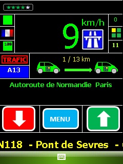
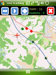
Mobbyway - Based on both internet mobile technologies and GPS, Mobbyway allows you to know easily, at any time, your relatives’ exact position on a map if they have accepted it and if they are connected to the network.
Mobbyway is also a help on the road network with a local alert system of a dangerous zone which is carried out with the network of members. Finally, Mobbyway will reference all the fixed radars in the countries where it is used and Mobbyway will indicate them to you.
Mobbyway was developed to allow:
- you to stay connected with your relatives wherever they are.
- your relatives to follow you visually and in real time.
- you to go back at any time to a place where you have already been on a specific date.
- you to travel safely on the road network thanks to the network members: The Mobbynautes.
- you to have a part in the world cartography OpenStreet Map
Like it? Share with your friends!
If you got an error while installing Themes, Software or Games, please, read FAQ.
Supported operating systems:
Windows Mobile 6 Classic, Windows Mobile 6 Professional, Windows Mobile 6.1 Classic, Windows Mobile 6.1 Professional, Windows Mobile 6.5 Professional
Similar Software:
GParkS The other day I was at a football game where I had to park on a golf course far from the stadium and ended up wandering around for 20 minutes trying to locate the car afterward
SupertweetGPS SupertweetGPS - SupertweetGPS allows you to send GPS based tweets to Twitter via SuperTweet.net. When you get a GPS lock enter the text and tap the button to send the Tweet with your current GPS. The program will send the tweet to Twitter.com with your current GPS. NOTE: To use Geolocation on Twitter in 'Settings/Account/Tweet Location' enable
TaxiGPSeds TaxiGPSeds - TaxiGPSeds can be used by a taxi driver that gets a GPS pickup. The program gets the current GPS and allows entry of the pickup GPS. Then you can view the distance and download the route map from the Google.com map service.
This program requires that you have both the 'BeanDLL.dll' file ** and ** the runtime files for Visual Basic on your PocketPC computer
RulerGPSeds RulerGPSeds is a full-featured GPS ruler with text exporter
MapGPSeds MapGPSeds - MapGPSeds is a full-featured GPS map downloader with GPS tagger. When you get a GPS lock you can download a 600x600 pixel map from Google.com. The maps have the GPS tagged on them. Then you can view the maps offline via GPS distance and customize the download views.
This program requires that you have both the 'BeanDLL
GPS4PPC GPS4PPC is an open source application, written with Basic4ppc that includes a set of tools for navigation and GPS data.
GPS4PPC supports:
- Converting coordinates between UTM and Lat / Lon.
- Converting coordinates in different datums.
- Calculating the distance and course between two coordinates.
- Show GPS data.
- Animated compass
trackr! Use trackr! to let people know where you are and where you have been. All you need is the Internet, a GPS receiver and your mobile phone (or a mobile phone with an internal GPS receiver)
RulerZIPer RulerZIPer allows you to find the distance from your current GPS to a US ZIP code. Start the GPS and when you get a GPS lock then enter the ZIP code. The program converts the ZIP code to GPS coordinates and displays the distance. This service is provided by USZIP
DocumentGPSed DocumentGPSed - DocumentGPSed allows you to create and view Pocket Word files based on your GPS. When you create a new Pocket Word file then the GPS location is appended to the end of the file. You can explore the Word files via distance of your current GPS.
This program requires that you have both the 'BeanDLL
FON Access Points for Vietnam FON Access Points for Vietnam - FON offers you a new Points of Interest service (POIs). This allows you to download FONspots directly to your navigation device.
What does that mean? You can download a Points of Interest file directly to your navigation device
Other Software by developer «Mobbyway»:
Mobbyway Mobbyway based on both internet mobile technologies and GPS, Mobbyway allows you to know easily, at any time, your relatives’ exact position on a map if they have accepted it and if they are connected to the network.Mobbyway is also a help on the road network with a local alert system of a dangerous zone which is carried out with the network of members

")
")