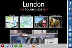
Rough Guides Map London... These guides are a series of fantastic interactive maps.
Produced in conjunction with the premier travel publisher Rough Guides.
Discover and explore London using full colour interactive linked maps, in this simple to use PDA version of The Rough Guides London.
Find all the top tourist spots and key attractions with ease, information on the city and its sights can be quickly displayed with links to photographs and map locations. All in a superb easy to use interface.
If you''re travelling to London, be sure you don''t leave home without this guide on your PDA.
The Rough Guide city maps includes:
Fully scrollable and interactive maps of the city.
Tap any location to display information and available links.
Intuitive navigation bar meaning you are never more than one click away from the information you require.
Map links allow you to directly link to other maps, photographs, or detailed views.
Categorised Find feature allowing you to quickly find any street, place of interest or station.
Categorised Information feature providing a wealth of information on the city, places of interest, etc.
1-Click Home feature, keeping the Home map always at hand.
Zoom function on all maps.
Special Offer Only $20.00
Hi Res & landscape displays supported.
Like it? Share with your friends!
If you got an error while installing Themes, Software or Games, please, read FAQ.
Supported operating systems:
Pocket PC 2002, Windows Mobile 2003, Windows Mobile 5.0, Windows Mobile 6 Classic, Windows Mobile 6 Professional, Windows Mobile 6.1 Classic, Windows Mobile 6.1 Professional, Windows Mobile 6.5 Professional
Similar Software:
Global Navigator Global Navigator is the most powerful and easy to use GPS navigation software on your Pocket PC with:3D GPS Navigation all over the world + Offline map and satellite image + Map range download+ 3D street view
Rough Guides Map Madrid Rough Guides Map Madrid... These guides are a series of fantastic interactive maps.
Produced in conjunction with the premier travel publisher Rough Guides.
Discover and explore Madrid using full colour interactive linked maps, in this simple to use PDA version of The Rough Guides Madrid
amAze (Sony Ericsson) AmAze is a first of its kind free navigation and local search service. It is free to download and use and it contains wide coverage of maps including aerial photo in Europe, North America, Australia and parts of Asia and Africa
London A-Z Visitor Map This publication has been designed for a Windows® Mobile-based Pocket PC (version 2002 or later) and the Pocket A-Z Viewer. This map of central London is designed especially for the tourist and covers an area extending to St
Tube London City Streets (2009 Edition) Tube London City Streets
This Tube package consists of a fully scrollable detailed map of the London Underground system and 9 linked GPS enabled A-Z street maps.
Plan journeys on the London Underground system, list details of the quickest routes and see a superb animated display of your journey tracking around the system map
Travel Beijing, China. Illustrated Guide, Phrasebook and Maps. Travel Beijing, China. Illustrated Guide, Phrasebook and Maps. - An illustrated city guide, phrasebook, and maps. Indulge Yourself with a personal tour guide on Your PDA. FREE General chapter, basic phrasebook, and a map in the trial version.
Features
Fully illustrated.
Historical overviews.
Interesting facts
TravelMaper TravelMaper - TravelMaper is a database of 661 major cities worldwide with Latitude/Longitude coordinates for each and direct Google.com map view/download. Select the city and select "view" or "download" map to download the Google.com Map. You can also customize the type of view and zoom via the options settings
PDA TileManager With PDA TileManager you can batch download OpenStreetMap maptiles.
Features:
Runs on Windows Mobile Devices with .NET CF 2.0 or above.
Read GPX track with trackpoints and waypoints
Direct support for Run
European Travel Guides Collection - London, Paris, Rome, and many more European Travel Guides Collection - London, Paris, Rome, and many more- Indulge Yourself with a personal tour guide on Your PDA. Each Guide includes a phrasebook and is illustrated with maps and photographs. 25 guides for the price of 5. FREE General Information chapter, basic phrasebook, and map in each trial version
Travel Mammoth Cave National Park - illustrated travel guide and maps- Travel Mammoth Cave National Park is a comprehensive travel guide illustrated with maps and photographs. Indulge Yourself with a personal tour guide on Your PDA. FREE General Information chapter and a map in the trial version.
Features
Fully illustrated.
Geology, Flora, Fauna and more.
Interesting facts.
Area Maps and Trail Maps
Other Software by developer «Visual IT»:
Tube Singapore (Series 60) Tube Singapore (Series 60) - Our highly acclaimed Tube application that guides you around the metro system of Singapore is now available for your Series 60 Symbian powered phone. An essential addition to your phone for locals and tourists alike.
· A detailed clear colour map of the Singapore metro system fully scrollable.
· Quick find station utility
Berlin Metro by Zuti Berlin Metro by Zuti - The new Berlin Metro map makes it easy to travel in and around the city using the Metro (U-Bahn) Suburban Rail (S-Bahn) and Tram (MetroTram and Straßenbahn) systems
Tube 2 London Touristic (UIQ3) Tube 2 London Touristic (UIQ3) - This map package for Tube 2 is the ideal map for the tourist or business traveller who needs to get around London using the Tube system and would like to know just exactly where they are. The map geographically locates all the central stations, making it much more informative than the official topological map
Hong Kong Subway for iPad by Zuti Hong Kong Subway for iPad by Zuti - Hong Kong Metro map makes it easy to travel in and around the city using the MTR transit railway, MTR light rail, MTR Airport Express, Trams, Cable Car and Ferry services
Tube 2 Seoul (UIQ) Tube 2 Seoul (UIQ) - This map package for Tube 2 consists of a fully scrollable detailed map of the Seoul Metropolitan Subway system.
Plan journeys on this system, list details of the quickest routes and see a superb animated display of your journey tracking around the system map
Tube Paris Pro (2009 Edition) Tube Paris Pro
New release with GPS support.
Tube plans all your journeys for you on the Paris metro & RER systems. It gives you the quickest routes, detailed on what trains to take and in what direction plus, service running times, fare zones, ticketing information and lots more...
Chicago Metro for iPad by Zuti Chicago Metro for iPad by Zuti - Chicago Metro map makes it easy to travel in and around the city using the CTA rapid transport system, the commuter services of Metrarail, Northern Indiana Commuter Transportation District and also the Water Taxi services
Tube 2 Madrid Pro (UIQ) Tube 2 Madrid Pro (UIQ) - This map package for Tube 2 consists of a fully scrollable detailed map of the Madrid metro system and linked street maps of central Madrid.
Plan journeys on the metro system, list details of the quickest routes and see a superb animated display of your journey tracking around the system map
Tube 2 London Pro (UIQ) Tube 2 London Pro (UIQ) - This map package for Tube 2 consists of a fully scrollable detailed map of the London Underground system and 2 linked A-Z street maps.
Plan journeys on the London Underground system, list details of the quickest routes and see a superb animated display of your journey tracking around the system map
Tube 2 Paris (UIQ) Tube 2 Paris (UIQ) - This map package for Tube 2 consists of a fully scrollable detailed map of the Paris metro and RER system.
Plan journeys on this system, list details of the quickest routes and see a superb animated display of your journey tracking around the system map


 Hi Res & landscape displays supported.

")

")


")

")

")
")

")
")
")