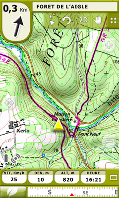
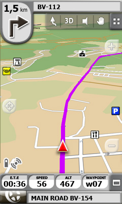
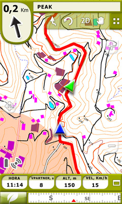
TwoNav for Windows Mobile - A dual navigation system (On-Road/Off-Road) to perform most of your outdoor activities (hiking, biking, skiing, geocaching, ...). TwoNav can also guide you when driving. A single solution for all your orientation needs.
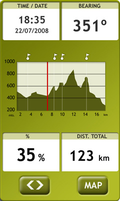
Load maps, tracks, routes and waypoints and get ready for your trip! - Save your performances by recording them as tracks (performance’s information is being controlled by more than 60 on-screen stats).
E-Roadbooks, data field alarms, Virtual Coach, Man Over board...It doesn’t matter which is your activity, TwoNav will cover all your needs!
· 15 days trial
Like it? Share with your friends!
If you got an error while installing Themes, Software or Games, please, read FAQ.
Supported operating systems:
Windows Mobile 6 Classic, Windows Mobile 6 Professional, Windows Mobile 6.1 Classic, Windows Mobile 6.1 Professional, Windows Mobile 6.5 Professional
Similar Software:
PDFJPGMaps PDFJPGMaps - PDFJPGMaps allows you to download a Google.com map of your current GPS and convert to PDF file format. You can draw on the map and also insert text into the maps as well as use the drawing tools. The JPEG libraries are from Independent JPEG Group. The map service is provided by Google.com. The PDF libraries are from JPEG2PDF by Hao Hu 2008
Metro Melbourne Metro Melbourne - Riding Melbourne's train system? Tired of having to carry around train timetable booklets in your pocket? Want to quickly find out arrival and departure time for any train in Melbourne? Metropolitan Melbourne has the answer for you.
Metropolitan Melbourne ("Metro Melbourne" for short) is an application for Windows Mobile phones
TravelGoogles TravelGoogles allows you to search and view 5,451 local businesses and services sorted from local distance from your home settings. Set your home location in the settings box and tap on a service on the list to view local listings. The business directory service is provided by Google
amAze (Samsung) AmAze is a first of its kind free navigation and local search service. It is free to download and use and it contains wide coverage of maps including aerial photo in Europe, North America, Australia and parts of Asia and Africa
gpsVP gpsVP - GPS navigation software for Windows Mobile devices. It shows vector and raster maps, records and shows tracks, shows multiple navigation parameters, manages and shows waypoints. It aims to be as usable as possible
Map of HongKong for City Advisor Map of HongKong for City Advisor - HongKong MTR map in Traditional Chinese for City Advisor. The stations can be find by Chinese characters and also by the first pinyin letters.
Instructions:
1. Download the map (zip file)
2. Extract the files in /CityAdvisor/maps
3. Open CityAdvisor -> Maps icon -> Menu -> Refresh
4
TwitterGPSer TwitterGPSer uses the GPS on your PocketPC to find your current latitude/longitude/speed and allows you to update Twitter.com. Tap the button to get the GPS lock and when the program gets the lock it will create a Tweet with a Google.com map link. This service is provided by Twitter
Rough Guides Map San Francisco Rough Guides Map San Francisco... These guides are a series of fantastic interactive maps.
Produced in conjunction with the premier travel publisher Rough Guides.
Discover and explore San Francisco using full colour interactive linked maps, in this simple to use PDA version of The Rough Guides San Francisco
Metro Metro helps you find your way in the public transport systems (subway, bus, trams, ...) in more than 400 cities around the world. FREE, FAST & ACCURATE. Simply enter you start and end stops, hit the "Go" button and the program finds the fastest route
Other Software by developer «CompeGPS»:
TwoNav for Android TwoNav for Android - A dual navigation system (On-Road/Off-Road) to perform most of your outdoor activities (hiking, biking, skiing, geocaching, ...). TwoNav can also guide you when driving. A single solution for all your orientation needs
TwoNav for iPhone/iPad TwoNav for iPhone/iPad - A dual navigation system (On-Road/Off-Road) to perform most of your outdoor activities (hiking, biking, skiing, geocaching, ...). TwoNav can also guide you when driving. A single solution for all your orientation needs


")


 / Belgium (Belgique) for City Advisor")


