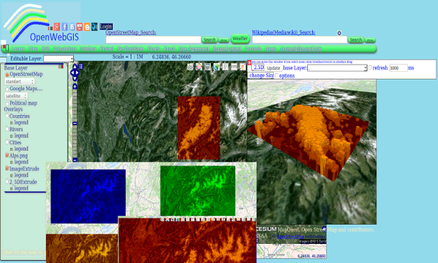
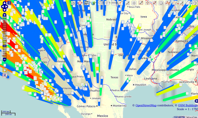
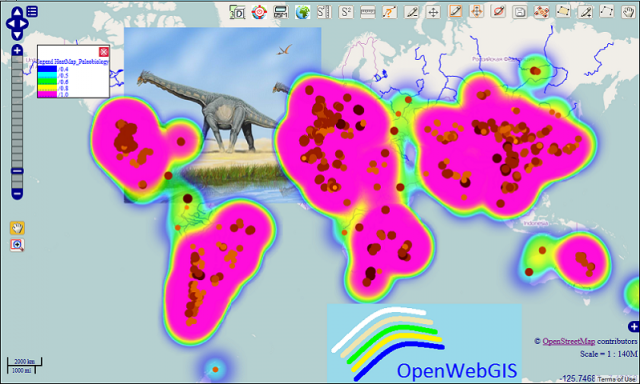
OpenWebGIS - OpenWebGIS is created for everyone who wishes to see and use a new free&open Geographic Information System(GIS). Please make your comments and suggestions. In this GIS you can use the extensive mathematical functionality to calculate and analyze your data. Using OpenWebGIS you will get a GIS at your disposal, it may be similar in functionality to some desktop GIS. Please support this project. The OpenWebGIS for Android has online and local version. In local version, you can use OpenWebGIS without having to connect to the server of OpenWebGIS and even without Internet connection. In local version, some functions do not work, but in future there will be the modification of these functions for the local version. The OpenWebGIS blog (http://openwebgisystem.blogspot.com/) provide a lot of information about possibilities for users' data operating. Full list of articles about OpenWebGIS: http://openwebgisystem.blogspot.com/2015/08/list-of-articles-about-openwebgis-in.html
Like it? Share with your friends!
Supported operating systems:
Google Android 10.x, Google Android 3.0, Google Android 3.1, Google Android 3.2, Google Android 4.0, Google Android 4.1, Google Android 4.2, Google Android 4.3, Google Android 4.4, Google Android 5.x, Google Android 6.x, Google Android 7.x, Google Android 8.x, Google Android 9.x
Similar Software:
Simply Facebook Simply Facebook is a light, simple, extensible Java library for accessing and modifying data available through the Facebook API. This is a useful tool on the Android platform, as the SDK does not ship with any means for accessing the Facebook API.
This library uses the Desktop mode approach for authentication
Learn Java XML Learn Java XML - Extensible Markup Language, XML is a very popular simple text based language to be used as a mode of communication between the applications. It is considered as a standard means to transport and store data. JAVA provides an execellent support and rich set of libraries to parse, modify or inquire XML documents
Learn MATLAB Learn MATLAB - MATLAB is a programming language developed by MathWorks. It started out as a matrix programming language where linear algebra programming was simple. It can be run both under interactive sessions and as a batch job. It can be run both under interactive sessions and as a batch job
Learn Avro Learn Avro - This tutorial is prepared for professionals aspiring to learn the basics of Big Data Analytics using Hadoop Framework and become a successful Hadoop developer. It will be a handy resource for enthusiasts who want to use Avro for data serialization and deserialization
Learn LISP Learn LISP - This reference has been prepared for the beginners to help them understand the basic to advanced concepts related to LISP Programming language. Lisp is the second-oldest high-level programming language after Fortran and has changed a great deal since its early days, and a number of dialects have existed over its history
PhoneGap PhoneGap is an open source development tool for building fast, easy mobile applications with JavaScript.
If you are a web developer who wants to build mobile applications in HTML and JavaScript while still taking advantage of the core features in the iPhone, Android, Symbian and Blackberry SDKs, PhoneGap is for you
Developers Best Practices Developers Best Practices - If you are working for software industry as a software engineer or a software developer, then I'm sure you are going to enjoy this tutorial. Try to relate the facts mentioned in the tutorial with your day-2-day life and find so many hidden facts, which are very obvious but we never gave our serious attention to them
learn XML-RPC learn XML-RPC - In Learn XML - RPC, you will learn what is XML-RPC and why and how to use it. This brief app will be extremely useful for all those who want to learn how to use XML-RPC to establish connections between computers across a network
Learn Apache POI Learn Apache POI - Learn Apache POI provides a basic understanding of Apache POI library and its features. Apache POI is a popular API that allows programmers to create, modify, and display MS Office files using Java programs. It is an open source library developed and distributed by Apache Software Foundation to design or modify Microsoft Office files using Java program
Comments on OpenWebGIS:
Comments not found
If you noted an error or download link is broken, please, report it via this page or use comments.
OpenWebGIS is compatible with your device HTC Jetstream (HTC Puccini)

")