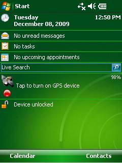
GPS2day is a today screen plug-in showing your current GPS coordinates, speed, satellite info, etc... Languages: English, Czech, Dutch, French, German, Hungarian, Italian, Japanese, Polish, Russian, Spanish.
Currently GPS2day program works as GPS informer. It supports both metric and U.S. (Imperial) units and shows a various types of information for users, such as:
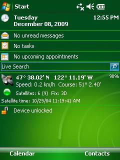
Current geographical coordinates (latitude, longitude);
Course and speed;
Some information about satellites and fix type;
Altitude followed by the fix 3D value;
Exact current date and time from the satellite atomic clock;
And battery life state which is important when you using GPS device.
What's New in This Release:
· Translation to Japanese was added
Like it? Share with your friends!
If you got an error while installing Themes, Software or Games, please, read FAQ.
Supported operating systems:
Windows Mobile 5.0, Windows Mobile 6 Classic, Windows Mobile 6 Professional, Windows Mobile 6.1 Classic, Windows Mobile 6.1 Professional, Windows Mobile 6.5 Professional
Similar Software:
Navigation BE-ON-ROAD DACH Q2/2011 Navigation BE-ON-ROAD DACH Q2/2011 - The new major version of be-on-road presents new features and is based on new platform which brings high level of reliability, portability and speed on almost any kind of device. The new be-on-road brings high value voice guided door-to-door navigation
RulerGPSeds RulerGPSeds is a full-featured GPS ruler with text exporter
Pocket PC Geocaching Tools Pocket PC Geocaching Tools - Many tools in one program to help you while you are geocaching.
What's included?
* Open GSAK databases directly
* HTML view
* Field Notes
* Hint decoder and decryption
* Several coordinate functions
* Solver
* Transformer (Text to Digits, etc
FON Access Points for Reunion FON Access Points for Reunion - FON offers you a new Points of Interest service (POIs). This allows you to download FONspots directly to your navigation device.
What does that mean? You can download a Points of Interest file directly to your navigation device
Mobile Notes "Where I've been?" feature
Record track lines, points of interest(POI).
Different colors indicate different speed route.
Record text, picture and video style POI.
Record raw gps nmea data for reference and analysis.
Attach pictures to tags of geographical information
OfficeGPSeds OfficeGPSeds - OfficeGPSeds is a full-featured Pocket Office GPS editor/viewer. When you create a new office file the current GPS is appended to the end of the file. You can view the files and edit them or edit the file and update it with your new GPS location.
This program requires that you have both the 'BeanDLL
EmailGPSeds EmailGPSeds - EmailGPSeds allows you to build email lists and update a person or all of the people on the list your current GPS with a Google.com map as an attachment. You can send the alert to just one email contact or all on the list. The email has a URL of your GPS from the Google.com.
This program requires that you have both the 'BeanDLL
WSpeedmeter Car speedometer for your windows mobile
GPSbyGPRS (Pocket PC) GPSbyGPRS is a version of GPSbySMS made for Pocket PCs without GSM module
TwitterGPSer TwitterGPSer uses the GPS on your PocketPC to find your current latitude/longitude/speed and allows you to update Twitter.com. Tap the button to get the GPS lock and when the program gets the lock it will create a Tweet with a Google.com map link. This service is provided by Twitter
Other Software by developer «Soft Expanse Group»:
ShellSwitcher ShellSwitcher was implemented as a Windows Mobile system utility for fast switching between well known shells: Spb Mobile Shell, Titanium (WM6.5 default shell), Touch Flo 3D, HTC Sense and classic Today screen. This application is based on UI Switcher knowledge with some additional features

")


")

