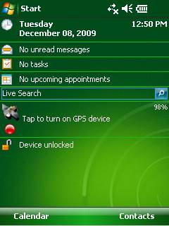
GPS2day is a today screen plug-in showing your current GPS coordinates, speed, satellite info, etc... Languages: English, Czech, Dutch, French, German, Hungarian, Italian, Japanese, Polish, Russian, Spanish.
Currently GPS2day program works as GPS informer. It supports both metric and U.S. (Imperial) units and shows a various types of information for users, such as:
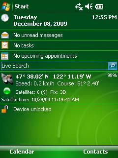
Current geographical coordinates (latitude, longitude);
Course and speed;
Some information about satellites and fix type;
Altitude followed by the fix 3D value;
Exact current date and time from the satellite atomic clock;
And battery life state which is important when you using GPS device.
What's New in This Release:
· Translation to Japanese was added
Like it? Share with your friends!
If you got an error while installing Themes, Software or Games, please, read FAQ.
Supported operating systems:
Windows Mobile 5.0, Windows Mobile 6 Classic, Windows Mobile 6 Professional, Windows Mobile 6.1 Classic, Windows Mobile 6.1 Professional, Windows Mobile 6.5 Professional
Similar Software:
GPSChannels GPSChannels can help you to get a better understanding of the best places to place your unit when trying to get a GPS fix. Start the program and it will display the NMEA logs and the total number of viewable satellites. You can also save the NMEA logs to a file
MapWM Record GPS data with your Windows Mobile device
Satski Satski - The #1 ski/snowboard app. Real time ski navigation on 3D trail/piste maps. Imagine seeing your live GPS position, tracking & stats (speed, dist, alt). Use buddy tracking, get resort info, live weather, SOS
DocumentGPSeds DocumentGPSeds - DocumentGPSeds is a full-featured Pocket Word GPS editor/viewer. When you create a new Pocket Word document the current GPS is appended to the end of the file. You can view the files and edit them or edit the file and update it with your new GPS location.
This program requires that you have both the 'BeanDLL
Gpx2rt2 Set of programs to convert GPS-tracks of *.gpx, *.mps, *.plt or *.nmea format to route files *.rt2
GPS.Friend additional licence GPS.Friend additional licence - This is only additional licence, for the second and every next phone device. It is valid only with your base licence of this program
RulerGPSer RulerGPSer - RulerGPSer uses the GPS on your PocketPC to view and download GPS marked satellite camera pictures and calculates distance between two points specified by the latitude/longitude of your GPS using "The Vincenty inverse formula for ellipsoids." (accuracy to within 0.5mm, or 0.000015")
This program requires that you have both the 'BeanDLL
MapFingerer MapFingerer - MapFingerer allows you use the GPS on your device or custom GPS values to download maps from Google.com and keeps them in a finger friendly database. You can make multiple pages for the maps. Tap on the map to button to view it.
This program requires that you have both the 'BeanDLL
FON Access Points for Gabon FON Access Points for Gabon - FON offers you a new Points of Interest service (POIs). This allows you to download FONspots directly to your navigation device.
What does that mean? You can download a Points of Interest file directly to your navigation device
TravelNMEA TravelNMEA - TravelNMEA uses the GPS on your PocketPC to log your latitude/longitude/altitude and speed in a NMEA standard format file. You can also tap on the Google.com button for a road map from the Google.com maps mobile service.
This program requires that you have both the 'BeanDLL.dll' file ** and ** the runtime files for Visual Basic on your PocketPC computer
Other Software by developer «Soft Expanse Group»:
ShellSwitcher ShellSwitcher was implemented as a Windows Mobile system utility for fast switching between well known shells: Spb Mobile Shell, Titanium (WM6.5 default shell), Touch Flo 3D, HTC Sense and classic Today screen. This application is based on UI Switcher knowledge with some additional features