GPS4PPC is an open source application, written with Basic4ppc that includes a set of tools for navigation and GPS data.
GPS4PPC supports:
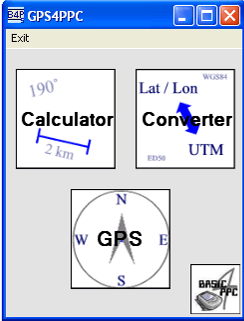
- Converting coordinates between UTM and Lat / Lon.
- Converting coordinates in different datums.
- Calculating the distance and course between two coordinates.
- Show GPS data.
- Animated compass.
- Built-in numpad for fast and easy input.
Like it? Share with your friends!
If you got an error while installing Themes, Software or Games, please, read FAQ.
Supported operating systems:
Windows Mobile 5.0, Windows Mobile 6 Classic, Windows Mobile 6 Professional, Windows Mobile 6.1 Classic, Windows Mobile 6.1 Professional, Windows Mobile 6.5 Professional
Similar Software:
DiaryGPS DiaryGPS - DiaryGPS can be used to make text diary notes based on your GPS. For each day the program creates a subfolder under the current storage folder with the text notes. You can view the notes via distance. Tap on the diary entry to view.
This program requires that you have both the 'BeanDLL
BikeDashboard BikeDashboard-This application provides training assistance (through graphs and stats) + navigation help (with moving maps and GPX file import & export) for mountainbike and roadbike enthusiasts.
BikeDashboard Features:
* Keep a track of their achievements:
o Where they have been.
o How long.
o How fast
Efficasoft GPS Utilities (Pocket PC) Efficasoft GPS Utilities for Pocket PC is the complete mobile GPS solution for Windows Mobile Pocket PC. It's the best companion for activities such as touring, hiking, geocaching... By defining a Go To list, you can even use it as a voice driving navigator!
· Designed GPS information overview.
· New! Voice "Go To" navigation function
FON Access Points for Palau FON Access Points for Palau - FON offers you a new Points of Interest service (POIs). This allows you to download FONspots directly to your navigation device.
What does that mean? You can download a Points of Interest file directly to your navigation device
CoffeeTimHortons CoffeeTimHortons uses the GPS on your PocketPC to find the 50 closest Tim Hortons shops sorted via GPS distance. Tap the button to start the GPS and when you get a lock tap on it to view the list of local Tim Hortons shops. You can also dial the store. The GPS maps and search service is provided by Google
Sunset GPS Logger Sunset GPS Logger-allows you to capture your activities (walking, running, cycling, snowboarding, hiking trails .etc) for later visualisation on Google maps. Combined with your existing digital camera it becomes an indispensable tool to simplify the process of geo-tagging those precious photos and memories
FON Access Points for El Salvador FON Access Points for El Salvador - FON offers you a new Points of Interest service (POIs). This allows you to download FONspots directly to your navigation device.
What does that mean? You can download a Points of Interest file directly to your navigation device
TwitterGPSer TwitterGPSer uses the GPS on your PocketPC to find your current latitude/longitude/speed and allows you to update Twitter.com. Tap the button to get the GPS lock and when the program gets the lock it will create a Tweet with a Google.com map link. This service is provided by Twitter
GParkS The other day I was at a football game where I had to park on a golf course far from the stadium and ended up wandering around for 20 minutes trying to locate the car afterward
RadarGPS Making of radars database and dangerous objects
Comments on GPS4PPC:
Comments not found
If you noted an error or download link is broken, please, report it via this page or use comments.
Attention! GPS4PPC may be not compatible with your device HTC P6300 (Panda)

")


")


