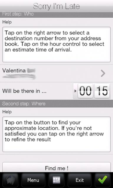
Sorry I'm Late - People are always in a hurry to get somewhere. A common issue is to inform someone waiting for us that we are, let’s say, a bit late and maybe reassure him that we will be there in some time. It would be great if we could send a message to that someone telling him our approximate location and an estimate time to reach the destination (maybe along with some excuses).
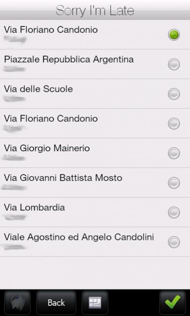
Sorry I'm Late was developed to achieve this task. This application allows a user to get his approximate location and then send it to someone else through an SMS. It has a friendly user interface and uses CellID localization instead of GPS. Also, it sends a more human readable message, unlike other similar applications which use GPS positioning to get a precise localization but then they send Latitude and Longitude coordinates or Google Maps links. This application uses street names instead of coordinates.
· Doesn't require GPS antenna
· Finger friendly UI thanks to SenseSDK from Steady Software
· Call history access to guess the most probable recipients
· Native SMS application used to send message to allow last minute changes
· Currently localized in English and Italian
What's New in This Release:
· added compression support on network calls to reduce bandwidth usage
Like it? Share with your friends!
If you got an error while installing Themes, Software or Games, please, read FAQ.
Supported operating systems:
Windows Mobile 5.0, Windows Mobile 6 Classic, Windows Mobile 6 Professional, Windows Mobile 6.1 Classic, Windows Mobile 6.1 Professional, Windows Mobile 6.5 Professional
Similar Software:
Where is... Where is... is a GPS tracking application for Windows Mobile devices. It gives you a free perception of distance and direction from your destination without any connection to the internet or an expensive program of navigation
GPS Speedometer GPS Speedometer is an attractive speed meter on the car dash for Windows Mobile phones.
Make sure you have .net framework installed. The setings.exe included in the attachment is from the Microsoft SDK samples, which can be used to set the COM port if you dont' have any other application.
This has been tested in HTC P3300 (Artemis) and HTC TyTN
Navigation BE-ON-ROAD DACH Q2/2011 Navigation BE-ON-ROAD DACH Q2/2011 - The new major version of be-on-road presents new features and is based on new platform which brings high level of reliability, portability and speed on almost any kind of device. The new be-on-road brings high value voice guided door-to-door navigation
GPSSateliter GPSSateliter displays the GPS satellite listings and strength as a graph. When you tap the 'Start GPS' button the program will look for GPS satellites and graphically display the decibel of each. The more bars the better your GPS coverage
FON Access Points for Guernsey FON Access Points for Guernsey - FON offers you a new Points of Interest service (POIs). This allows you to download FONspots directly to your navigation device.
What does that mean? You can download a Points of Interest file directly to your navigation device
amAze (LG) AmAze is a first of its kind free navigation and local search service. It is free to download and use and it contains wide coverage of maps including aerial photo in Europe, North America, Australia and parts of Asia and Africa
Traffic Vizzion (12 month subscription) IMPORTANT: Do not operate this product while driving; park the vehicle first. It is your sole responsibility to place, secure and use your mobile device in a manner that ensures safe driving
StoreGPSed StoreGPSed - StoreGPSed allows you to make and edit text notes about stores based on your GPS. The program lists the stores via GPS distance from your current location. Tap on the store to view and edit the text notes for the store. You can also view and export a map of the stores on with the Google.com service.
This program requires that you have both the 'BeanDLL
Phonetracker Locator Phonetracker Locator -transforms a Windows Mobile 5.0 / WM6 PPC Phone with built in GPS receiver or external Bluetooth GPS receiver into a GPS/GSM tracking device.
Received SMS are checked for location statements by Phonetracker4Free and transferred to Google Maps Mobile independently
GPSMapings GPSMapings uses the GPS on your PocketPC to find your current location and allows you to view your position on a map from the Google.com maps service. You can customize the maps zoom, and type via the 'Options' in the toolbar. The maps service is provided by Google
Other Software by developer «ste09»:
Mobile First Aid Mobile First Aid - According to a recent study (Gray, 2008) there are abount 1.8 mobile phones per person around the world. Since everyone of us can find himself in the need to give some first aid assistance to someone injured, it is simple to merge these two data and say "why don't give these people a first aid application to be installed on their mobile phones

")


")
")


