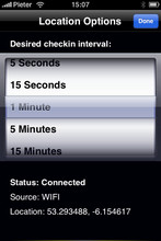
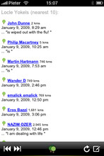
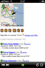
Locle is a mobile application that lets users see where their friends and family are without the need for GPS. Wherever you are, always find out where people are and meet them for lunch, drinks or whatever you want to do. Just make sure you don't miss out on anything.
Like it? Share with your friends!
If you got an error while installing Themes, Software or Games, please, read FAQ.
Supported operating systems:
Google Android 1.0, Google Android 1.5, Google Android 1.6, Google Android 10.x, Google Android 2.0, Google Android 2.1, Google Android 2.2, Google Android 2.3, Google Android 3.0, Google Android 3.1, Google Android 3.2, Google Android 4.0, Google Android 4.1, Google Android 4.2, Google Android 4.3, Google Android 4.4, Google Android 5.x, Google Android 6.x, Google Android 7.x, Google Android 8.x, Google Android 9.x, Java ME, Java Nokia 240x320, Java SE 240x320, Palm OS 3.x, Palm OS 4.x, Palm OS 5.x, Pocket PC 2002, RIM BlackBerry OS 4.0, RIM BlackBerry OS 4.1, RIM BlackBerry OS 4.2, RIM BlackBerry OS 4.3, RIM BlackBerry OS 4.5, RIM BlackBerry OS 4.6, RIM BlackBerry OS 4.7, RIM BlackBerry OS 5.0, RIM BlackBerry OS 6.0, Windows Mobile 2003, Windows Mobile 5.0, Windows Mobile 6 Classic, Windows Mobile 6 Professional, Windows Mobile 6.1 Classic, Windows Mobile 6.1 Professional, Windows Mobile 6.5 Professional
Similar Software:
TextMapperer TextMapperer - TextMapperer allows you to create named text based GPS maps. When you get a GPS lock then you can create a new map and enter text for the area. When you save the text the map is downloaded and the text and GPS is appended to the end of the map with current GPS
amAze (Samsung) AmAze is a first of its kind free navigation and local search service. It is free to download and use and it contains wide coverage of maps including aerial photo in Europe, North America, Australia and parts of Asia and Africa
Great Britain Pocket A-Z Map 2009 Great Britain Pocket A-Z Map 2009 - This publication has been designed for a Windows® Mobile-based Pocket PC (version 2002 or later) and The Pocket A-Z Viewer. Covering the same area as the Great Britain Mini Road atlas, this publication consists of coloured road mapping of Great Britain which shows motorways, primary routes and main roads
PrettyMap View maps of Earth and other planets with PrettyMap! See current day and night areas, learn geography with the quiz, enjoy 3D elevation relief, measure distances, edit locations!
TerraTrack Recorder 7 Route guidance in 3D view, makes navigation processes very simple and intuitive
Map Creator for City Advisor Map Creator for City Advisor - Create public transportation maps for use with City Advisor.
What's New in This Release:
· Enable Special TimeTable editing.
· Enable customize peeks.
· Enable CAX format map generation.
· Enable Language-Code Selection for accent insensitive search.
· Accent insensitive station search
GPSed Pro GPSed - Mapping Your Impressions
GPSed is a service for trip tracking from mobile. In real time tracks are traced on Google maps and stored in an online archive. With a simple geotagging feature it is possible to pin photos to a map precisely at a place they were taken
MobileMaps MobileMaps - This program connects you to pda.maporama.com, an online map service. NOTE: You must be connected to the internet to use this program.
This program requires that you have both the 'BeanDLL.dll' file ** and ** the runtime files for Visual Basic on your PocketPC computer
gpsVP gpsVP works on virtually any Windows platform including mobile ones. It shows vector and raster maps, records and shows tracks, shows multiple navigation parameters, manages and shows waypoints. It aims to be as usable as possible.
What's New in This Release:
· Geoid correction matrix: Updated values Atlantic & east America's
Other Software by developer «Leprecian»:
not found
Comments on Locle:
Comments not found
If you noted an error or download link is broken, please, report it via this page or use comments.
Locle is compatible with your device HTC Touch Pro 2 T7373 T7380 (HTC Rhodium 100)

")


")


