|
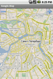
RMaps is a navigation tool. You can use RMaps as an online map viewer for some popular maps. And as an offline map viewer for your own maps created on the PC.
· Auto rotate map in driving direction.
· Auto rotate map in the northern direction.
· Compass on the map.
· Auto-follow function.
· Online search.
· Full screen mode.
· GPS and wireless network mode.
· Indicator accuracy like on Google map.
What's New in This Release:
· Dashboard. Long press on dashboard to add or change value
· I am here: Long press on the screen to point your location without GPS
· Target point (use the map context menu)
· Ability to use volume controls to zoom map
· Ability to export import POI category with the POI
· Ability to use custom cursors
· Ability to download online map directly to online cache
· Updated URLs
· Improving downloader service, Track writer service
· Fixed some GPX importing bugs
What's New in 0.9.3.1:
· Fixed add POI, search bugs
What's New in 0.9.3:
· Been improved measure tool
· Ability to use the app on a devices without GPS
· Long press on the map now shows the coordinates etc. Clicking on a black bubble shows the context menu
· Coordinates formatting preference
· Ability set Zoom controls at the right
· Ability download to offline a layers
· Build-in ability to download Geology and Geophysics offline maps from www.dpi.nsw.gov.au/minerals
· Fix scale bar bug
· Fix some POI bug
What's New in 0.9.2:
· Opened Google Community RMaps on Google+ (users support, beta testing)
· Measuring distances (Menu - Tools - Measure)
· Distance circles around current location
· Joining multiple tracks into one
· New Relief map
· Reload/update tiles tool on the screen online map (Menu - Tools - Reload screen tiles)
· OSGB 36 for offline Ordnance Survey Map
· Compass fix
· Loading circles after download fix
· White POI on SONY fix
· Google.Land, Google.Satellite fix
What's New in 0.9.1:
· BING maps (Road, Aerial, Hybrid)
· USA Topo maps, ArcGIS USA maps, USGS Topo maps
· Improve usability of POI category list
· Improve usability of maps list in settings
· Line between current GPS location and center of screen
· Share POI function
· Altitude field in POI activity
· Map offset function (useful for Chinese users)
· Stretch factor of map, ability to enlarge picture of any map
· Offline maps bug fix
What's New in 0.9.0.1:
· Debug bug fix
· Correct translation
What's New in 0.8.9:
· Crosshair on center of the map
· Added new map maps.refuges.info
· Bug fix
What's New in 0.8.7.3:
· New preference Directory
· Now RMaps stores tiles of online maps on sdcard in sqlite format
What's New in 0.8.6.1:
· Bug fix
What's New in 0.8.6:
· New maps: VFR (avcharts.com), MyTopo, OSM MTB Mapa Česká republika
· Error report
· Bug fix: Multitouch, Scale bar, more
What's New in 0.8.5:
· Scale bar, Units property
What's New in 0.8.4.1:
· Multitouch zooming
· Zoom buttons settings: top, bottom, hide
What's New in 0.8.3.1:
· Fix export track to GPX, KML file
 
 
|
