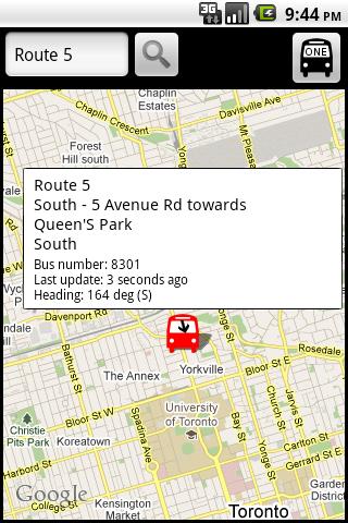
TorontoBusMap - TorontoBusMap shows locations and predicts bus times in Toronto using GPS info from the Toronto Transit Commission.
What's New in This Release:
· GPS now turns on when you start the app to allow quicker location lookup times. NOTE: There is also a new checkbox in the settings to disable this if you do not want it
· all stops mode added! This will show and update all bus stops around the center of the screen, not just ones on your current route. May be slow for older phones
· recently updated stops are temporarily colored green to show that they've updated
· search now searches stop titles in addition to routes
Like it? Share with your friends!
Supported operating systems:
Google Android 1.5, Google Android 1.6, Google Android 10.x, Google Android 2.0, Google Android 2.1, Google Android 2.2, Google Android 2.3, Google Android 3.0, Google Android 3.1, Google Android 3.2, Google Android 4.0, Google Android 4.1, Google Android 4.2, Google Android 4.3, Google Android 4.4, Google Android 5.x, Google Android 6.x, Google Android 7.x, Google Android 8.x, Google Android 9.x
Similar Software:
Metroid Metroid is an Android itinerary planning application meant to help users with public transportation systems worldwide. Metroid has been designed with extensibility in mind. It is able to support any public transportation system provided that the right map is available.
Metroid is based on maps
TripIt - Travel Organizer TripIt Travel Organizer puts all your travel plans right on your Android! - Forward travel confirmation emails to plans@tripit.com to build a trip itinerary
Snarl Traffic The best way to view Australian traffic....and it's free! The popular application now available on Android! Supporting NSW, Victoria and Queensland, Snarl Traffic will provide you with the traffic information you need when you need it
TripIt: Travel organizer TripIt - is an application for planning all your trips in one place. This utility can create a master-route for each of your trips. With the help of this application you can get access to your plans any time and any place. Moreover, the program is synchronized with a calendar so as you don't forget about other events happening on the dates of your trips
Otobüs Saatleri ve Takip Sistemi Otobüs Saatleri ve Takip Sistemi - Bu uygulama sayesinde beklediğiniz otobüsün nerede olduğunu öğrenebileceksiniz! Ayrıca tüm seferlerin otobüs saatlerini kolayca takip ederek, hayatınızı kolaylaştırabilirsiniz
indian rail train PNR and hotels indian rail train PNR and hotels - Official ixigo indian rail app recommended by Google CEO, Sundar Pichai
Store Hours Store Hours by HourDB is a store hours look up service for the US. It currently indexes around 320,000+ locations, which are easily searchable. So, ever wonder when the restaurant chain by your house closes? Finally you can find out. Or, if you want to find all the open locations around you at 3AM -- you can do it
SoMo - Plan & Commute together SoMo - is the best way to plan, book and coordinate a trip with a family or friends by city transport, taxi or car. With all that you can create a single trip as well as a repeating event. With this program you can invite friends to join your trip, share information on the trip and get all data about the trip in a real time mode
Shanghai Hotels Search Shanghai Hotels Search
Want to go Shanghai ?
Looking for a hotel in this city or nice hotels at lowest rates?
Places you cant Visit Places you cant Visit - While most people are happy just taking the occasional trip to the beach, there are those of us that long for something more…an adventure. And although most places on Earth are accessible to the determined traveler, some places are just better off left alone
Other Software by developer «George Schneeloch»:
Los AngelBus Los AngelBus - This application shows locations and predicts bus times in Los Angeles using GPS info from the Los Angeles Metro.
What's New in This Release:
· GPS now turns on when you start the app to allow quicker location lookup times
BostonBusMap BostonBusMap is an application for Android phones. It uses GPS data provided by the MBTA to plot the real-time location of buses on a map.
What's New in This Release:
· GPS now turns on when you start the app to allow quicker location lookup times
UMichBusMap An Android application which shows the live positions of University of Michigan buses overlayed on Google Maps

")