Categories: Business & Profession, Travel & Navigation
Upload date: 27 Mar 12
Developer: Idea Matters
License: Freeware
Downloads: 17212 File Size: 587 Kb
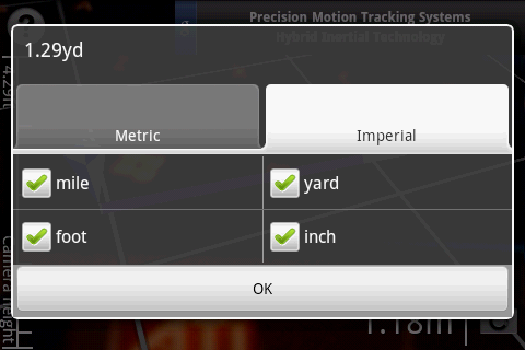
Surveyor - Measure distances with a single click on your Android phone!
All you need to do is point your phone to the object you want to measure, and select the point where it touches ground from the screen.
What's New in This Release:
· Use gyroscope to improve accuracy and smoothness of Augmented Reality result.
· Now support all gyroscope equipped devices (previously only Gingerbread).
What's New in 2.4.1:
· New aim mode for easier control and better accuracy
· Bug fixes
Like it? Share with your friends!
Supported operating systems:
Google Android 1.5, Google Android 1.6, Google Android 10.x, Google Android 2.0, Google Android 2.1, Google Android 2.2, Google Android 2.3, Google Android 3.0, Google Android 3.1, Google Android 3.2, Google Android 4.0, Google Android 4.1, Google Android 4.2, Google Android 4.3, Google Android 4.4, Google Android 5.x, Google Android 6.x, Google Android 7.x, Google Android 8.x, Google Android 9.x
Similar Software:
GPS Speed GPS Speed - Turn your Android phone into a digital speedometer! Nice Compass view + big digital speed view. You can use menu to switch m/s, MPH, KPH and Knot.
What's New in This Release:
· minor fix
What's New in 5.4:
· support APP2SD
What's New in 4
eGPS Elevation EGPS Elevation has greatly improved altitude and elevation readings. In a typical Android GPS, altitude readings are notoriously inaccurate. eGPS Elevation will even show how deep is the nearest water area
How Tall Pro How Tall Pro - Attention! Only play on soft area or with a nice catcher!
Sound may scare others!
How-To
Thumb on screen and drop your Android phone VERTICALLY. The droid will find out the height, and then analyze who you are
Marine Compass Key Unlock features for the Marine Compass. *** IMPORTANT : Please note that this application cannot be directly opened and will not appear in the home screen. It's purpose is only to unlock Marine Compass advanced features. Please install Marine Compass first (free)
myAltitude See your Altitude, Min and Max Altitudes, Oxygen level and more! Wear Supported!
MUUDS MUUDS - Our Patented, color-coded, UV resistant PVC MUUDS Markers are a new and unique way to mark the exact depth of underground utilities. They are excellent way to prevent future excavation disasters
BigTinCan Speed Proof Speed Proof logs your current speed, location and so on to a GPX file as fast as the GPS chip updates the system
Talking Compass Talking Compass speaks your current heading and provides haptic feedback as your cross over any of the cardinal directions.
Touch the screen to hear your heading. Stroke the screen up/down to adjust verbosity
GPS Status & Toolbox GPS Status & Toolbox - Be a GEEK: Get the most out of your phone. Raw GPS data at your fingertips.
Display your GPS and sensor data: position and signal strength of satellites, accuracy, speed, acceleration, bearing.
Tools included: compass with magnetic and true north, leveling tool, mark or share your location and navigate back later
Elevation and Sea Depth Elevation and Sea Depth displays elevation and/or sea depth in direction of phone.In order to use it properly, hold your phone on flat surface and away from ferrous metal objects and electromagnetic fields
Other Software by developer «Idea Matters»:
Sensor List Sensor List lists all sensors available on the device along with their current values and a plot to display their changes over time.
Including accelerometer, magnetic field, orientation, temperature, light...
Can be a handy tool for development or hardware testing purpose
GeoRecorder The ONLY GPS logger app you'll ever need on the Android platform!
MemoDroid MemoDroid - Memory training tool for Android. Utilizes "spaced repetition" theory to manage intervals for every item based on your responses in previous repetitions in order to boost the efficiency of your learning.
Import SuperMemo data including learning progress

")