GPSToday-GeoTerrestrial GPSToday now brings an unbeatable combination of location features to your mobile device.
Driving/Walking directions in many countries, with traffic-optimization option.
Log file plotting on map and animated "playback". Also, the geologger will now never clip corners, and will perfectly follow loopy highway ramps. You can now also upload your log-files to the desktop website.(full-featured log-editing on the desktop coming soon)
Location Tracking and sharing (GeoLocation). Track your location history online for your own private use, or share with friends/family. The power-saving ability of GPSToday means you can leave it on indefinitely without worrying about the battery.
Easily and privately (or publicly) share points-of-interest, pictures, messages with like-minded folks (GeoGroups). eg. Track or update swine-flu locations, right from your phone. The possibilities are endless.
'Slideshow' through all your address-book contacts on the map, or through driving directions, or local search results, or all friends' mobile locations
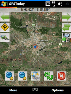
Satellite,Hybrid map views, and many more enhancements for ease of use.
Nearly worldwide support for many features that were previously US only.
Essentially the works, all in a still small package. More features are listed below the screenshots.
This software will not work on OS older than Windows Mobile 5.0 versions, or on any non-touchscreen smartphone. Data plan is recommended for online map features, but not necessary for offline features like geologging or geotagging. An Integrated GPS is advisable (but not mandatory) to fully enjoy the software.
Like it? Share with your friends!
If you got an error while installing Themes, Software or Games, please, read FAQ.
Supported operating systems:
Windows Mobile 5.0, Windows Mobile 6 Classic, Windows Mobile 6 Professional, Windows Mobile 6.1 Classic
Similar Software:
MapGPSeds MapGPSeds - MapGPSeds is a full-featured GPS map downloader with GPS tagger. When you get a GPS lock you can download a 600x600 pixel map from Google.com. The maps have the GPS tagged on them. Then you can view the maps offline via GPS distance and customize the download views.
This program requires that you have both the 'BeanDLL
FON Access Points for Philippines FON Access Points for Philippines - FON offers you a new Points of Interest service (POIs). This allows you to download FONspots directly to your navigation device.
What does that mean? You can download a Points of Interest file directly to your navigation device
FileGPSeds FileGPSeds - FileGPSeds is a full-featured GPS tagged file viewer. You can browse the folders of the PocketPC for GPS tagged files and view the current distance from your GPS. You can also map the file GPS or all files in a folder on a map from Google.com maps service.
This program requires that you have both the 'BeanDLL
TextGPSs TextGPSs - TextGPSs can be used to make text notes with a GPS tag as the text file name and view the distance in meters of each text file in distance order via GPS. You can store your files on the storage card. You can also view the text entries with Google maps.
This program requires that you have both the 'BeanDLL
Xylon GPS Data Logging for the Pocket PC Xylon GPS Data Logging for the Pocket PC - Xylon captures and stores GPS information as required and configured by you. This is true low cost flexible data acquisition, the only requirements being a Pocket PC and GPS capture module. Depending upon your requirements you can use anything from a $60 GPS board to a real time kinetic system
FON Access Points for Austria FON Access Points for Austria - FON offers you a new Points of Interest service (POIs). This allows you to download FONspots directly to your navigation device.
What does that mean? You can download a Points of Interest file directly to your navigation device
FON Access Points for Turkey FON Access Points for Turkey - FON offers you a new Points of Interest service (POIs). This allows you to download FONspots directly to your navigation device.
What does that mean? You can download a Points of Interest file directly to your navigation device
VoiceGPSeds VoiceGPSeds - VoiceGPSeds is a full-featured voice recorder with GPS location tagger. You can make voice recordings and the GPS location is appended to the end of the file. You can browse the files via GPS distance. Tap on the wave file to play it back.
This program requires that you have both the 'BeanDLL
GPSLoggerer GPSLoggerer logs and displays the data that comes from your GPS unit in your device in NMEA sentences. You can select the output to a NMEA extension or or text file extension. When you select save all logs after the save will be saved to the file. When you select close the logging will stop
PocketGPS Map PocketGPS Map-The program views calibrated bitmap maps (moving maps) on Pocket PC / WinCE platform.
Additionaly it supports using GPS device to retrieve user position and show it (with other marks) in map - making it very handy for geocaching
Comments on GPSToday:
Comments not found
If you noted an error or download link is broken, please, report it via this page or use comments.
GPSToday is compatible with your device Hyundai A200