New release with GPS support & Live travel information.
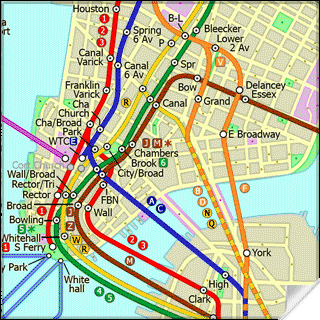
This superb map package for Tube is the ideal map for anyone who needs to get around New York City using the MTA subway system and would like to know just exactly where they are. The map geographically accurately locates all of Manhattans central stations, overlaid onto a street map. This Pro version also comes with a more detailed linked street map so with a quick tap you can jump to higher detailed street map that shows more street detail as you zoom in. Both maps are GPS enabled.
See where the subway lines actually run & where the stations are in relation to you.
Use the in built GPS to locate yourself on the street map.
See easily if you can walk rather than take the subway.
See how far Manhattan places and many points of interest are actually away.
Mark your own favourite or useful locations on the map i.e. restaurant, bar, hotel etc.
Includes hundreds of searchable points of interest with further detailed information.
Not only will Tube show you where all the most popular locations are situated it will also plan the shortest journey there by subway, giving you detailed directions on what trains to take and in what direction but also service running times, fare zones, ticketing information etc. plus see a superb animated display of your journey tracking around the system map.
New Feature: This new version comes with Live Info, get all the latest travel alerts on the NYC subway system direct into your Tube application.
New Feature: If you have a built in or connected GPS receiver on your device you can now locate exactly where you are on the map.
One of a series of Tube product from Visual IT, many cities from all around the world are available.
Like it? Share with your friends!
If you got an error while installing Themes, Software or Games, please, read FAQ.
Supported operating systems:
Pocket PC 2002, Windows Mobile 2003, Windows Mobile 5.0, Windows Mobile 6 Classic, Windows Mobile 6 Professional, Windows Mobile 6.1 Classic, Windows Mobile 6.1 Professional, Windows Mobile 6.5 Professional
Similar Software:
Travel Milan, Italy - illustrated travel guide, phrasebook, and maps Travel Milan, Italy - illustrated travel guide, phrasebook, and maps - An illustrated city guide, phrasebook, and maps. Indulge Yourself with a personal tour guide on Your PDA. FREE General Info, basic phrasebook and a map in the trial version.
Features
Fully illustrated.
Historical overviews.
Interesting facts
TravelMaper TravelMaper - TravelMaper is a database of 661 major cities worldwide with Latitude/Longitude coordinates for each and direct Google.com map view/download. Select the city and select "view" or "download" map to download the Google.com Map. You can also customize the type of view and zoom via the options settings
CarDirections CarDirections - This program connects you to MapQuest.com, an online car map/direction service. NOTE: You must be connected to the internet to use this program.
This program requires that you have both the 'BeanDLL.dll' file ** and ** the runtime files for Visual Basic on your PocketPC computer
amAze (Samsung) AmAze is a first of its kind free navigation and local search service. It is free to download and use and it contains wide coverage of maps including aerial photo in Europe, North America, Australia and parts of Asia and Africa
TrekBuddy Trekbuddy is a J2ME application to be used with a GPS receiver. It is designed to work with every Java-enabled device. It features capabilities such as: * GPS tracking and simple navigation * bitmap maps (without zoom, you can store bitmap maps with different resolution instead)
Travel Mammoth Cave National Park - illustrated travel guide and maps- Travel Mammoth Cave National Park is a comprehensive travel guide illustrated with maps and photographs. Indulge Yourself with a personal tour guide on Your PDA. FREE General Information chapter and a map in the trial version.
Features
Fully illustrated.
Geology, Flora, Fauna and more.
Interesting facts.
Area Maps and Trail Maps
TrackMe TrackMe - Tool that stores GPS positions and uses that information to generate KML files that can be used by Google Earth or Google Maps for displaying realtime or prerecorded tracks.
The data can be stored locally on your PDA or remotely on a server. You can use my server (free of charge) for storing your data
HomeDirections HomeDirections - This program allows you to set your home location. You can then enter an address from home or to home and the program will give you directions. NOTE: You must be connected to the internet.
This program requires that you have both the 'BeanDLL.dll' file ** and ** the runtime files for Visual Basic on your PocketPC computer
PocketGPS Map PocketGPS Map-The program views calibrated bitmap maps (moving maps) on Pocket PC / WinCE platform.
Additionaly it supports using GPS device to retrieve user position and show it (with other marks) in map - making it very handy for geocaching
Tube 2 New York Geo (UIQ3) Tube 2 New York Geo (UIQ3) - This superb map package for Tube 2 is the ideal map for anyone who needs to get around New York City using the MTA subway system and would like to know just exactly where they are.
The map geographically accurately locates all of Manhattans central stations, overlaid onto a street map
Madrid Metro by Zuti Madrid Metro by Zuti - The new Madrid Metro 10 map makes it easy to travel in and around the city using the the Metro, Renfe Rail and Metro Ligero Rail services. Unlike old fashioned schematic style maps this product contains a geographically accurate central area showing major streets, parks and places of interest etc, allowing the user to easily get their bearings
TUBE 2 Rome Pro (Palm OS) TUBE 2 Rome Pro (Palm OS) - This map package for Tube 2 consists of a fully scrollable detailed map of the Rome metro & rail system and linked high quality street maps of central Rome.
Plan journeys on the metro system, list details of the quickest routes and see a superb animated display of your journey tracking around the system map
Tube Seoul (Palm OS) Tube Seoul (Palm OS) - An award winning and highly acclaimed Palm OS application that guides you around the complex subway system of Seoul. An essential addition to your Palm device for locals and tourists alike.
Tube's features include:
A detailed clear colour (or grey scale) map of the transport system fully scrollable.
Quick find station utility
Tube 2 Hong Kong (UIQ) Tube 2 Hong Kong (UIQ) - This map package for Tube 2 consists of a fully scrollable detailed map of the Hong Kong metro & rail system.
Plan journeys on this system, list details of the quickest routes and see a superb animated display of your journey tracking around the system map
Tube 2 Engine (UIQ) Tube 2 Engine (UIQ) - Transform your phone into a fully scrollable detailed map of one of the worlds subway or metro systems.
See your journeys come alive with a superb animated display.
Save hours by automatically having the quickest routes to hand, with all the details you need including line changes, platform directions and accurate journey times
The Pad (V3) The Pad (V3) - The Pad... This simple yet invaluable application is the fastest way to write and draw on a Windows Mobile Professional / Pocket PC PDA or phone
London Mini A-Z for iPad London Mini A-Z for iPad - This clear and colourful high quality map is a digital rendition of the famous "London A-Z Mini Atlas" and covers an area from West Hendon in the North West to Grove Park in the South East. Add this application to you iPad and you will have instant access to all 352 pages of the London Mini A-Z printed map
Tube Toronto (UIQ) Tube Toronto (UIQ) - Our award winning and highly acclaimed application guides you around the subway system of Toronto is now available for your Symbian UIQ phone.
An essential addition to your P800 / P900 / P910 if you travel in or around this city
· A detailed clear colour map of the Toronto subway system fully scrollable.
· Quick find station utility
Tube 2 Madrid (Palm OS) Tube 2 Madrid (Palm OS) - This map package for Tube 2 consists of a fully scrollable detailed map of the Madrid metro system.
Plan journeys on this system, list details of the quickest routes and see a superb animated display of your journey tracking around the system map


")


")


![USA-OH [Ohio] Map for EagleEye PDA Tracking System](https://static.mobyware.org/data/images/def_program_reduced.png "USA-OH [Ohio] Map for EagleEye PDA Tracking System")
")

")
")
")
")
")

")
")