mdNavMobile is a waypoint-based GPS navigation solution for the Windows Mobile platform. It can guide you from waypoint to waypoint while keeping you informed of all relevant navigation data. All NMEA-data from a GPS is automatically logged to file so you can 'replay' a trip with variable speed.
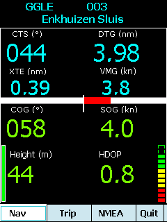
· GPS info: Latitude, Longitude, COG, SOG, Height, Satellites, HDOP and NMEA-stream
· Waypoint info: CTS, DTG, TTG, VMG, XTE
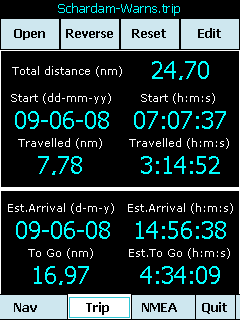
· Trip info: Total distance, Start, Travelled distance/time, DTG, TTG, ETA
· Reverse and Reset trips
· Scroll to next/previous waypoint
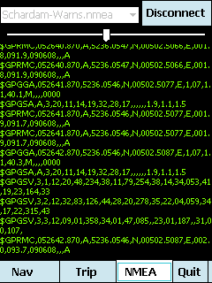
· Logs full NMEA stream from GPS to Storage Card
· Simulation using NMEA-log files with variable speed (factor 0.01-100)
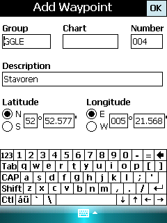
· Create/Edit Trips and Waypoints
· Show data in nm/kts/ft or km/kmh/m
· Change colors
· Trip-files also editable with notepad
· Totally free
Like it? Share with your friends!
If you got an error while installing Themes, Software or Games, please, read FAQ.
Supported operating systems:
Windows Mobile 5.0, Windows Mobile 6 Classic, Windows Mobile 6 Professional, Windows Mobile 6.1 Classic, Windows Mobile 6.1 Professional, Windows Mobile 6.5 Professional
Similar Software:
SirfGPSTweaker SirfGPSTweaker - application for displaying output from NMEA or SIRFBINARY based GPS device.
It has autodetection of data format (so it works both in NMEA or SIRF with on the fly detection). It can display statistics and data panel for cockpit use. Cockpit mode includes history graphs for speed and altitude
SmokeGPSs SmokeGPSs - SmokeGPSs can be used to with GPS to help you to daily reduce the amount you smoke until you quit. For each day the program tracks the GPS location of each time you smoke and the total count for the day. You can also view the entries on a calendar interface.
This program requires that you have both the 'BeanDLL
Map4Fun Taipei-GPS Map4Fun Taipei-GPS - Going to Taipei? just download it for free!
Attractions and shops/hotels/restaurants... in Taipei... find coupons/POI instant video/communication links...on hand, and much more of major Asian cities at Map4fun.
1. Taipei Information.
2. Useful numbers.
3. Tourist attraction.
4. East Taipei area map.
5. Jhonshan area map.
6. Sinyi area map
Turbo GPS Turbo GPS -The most flexible and precise track / offroad GPS you have seen. Available for both Windows and Windows Mobile
TravelAddresserer TravelAddresserer uses the GPS on your PocketPC to find your current latitude/ longitude/ speed/ altitude and Googles the Country/ Street address and allows you to view your position on a map from the Google.com maps service. You can customize the maps zoom, and type via the 'Options' in the toolbar
VirtualGPS Virtual GPS is a free, small utility, which fully emulates GPS module and returns your location (by using cellular towers).
Accuracy of coordinates is about 200m in urban area and up to 5km in countryside. Screenshots are explaining how to use VirtualGPS with navigation software (e.g. "Google Maps")
SirfTech Pocket PC program for checking and setting practically all SiRF GPS settings and evaluating changes
Navigation BE-ON-ROAD UK and Eire Q2/2011 Navigation BE-ON-ROAD UK and Eire Q2/2011 - The new major version of be-on-road presents new features and is based on new platform which brings high level of reliability, portability and speed on almost any kind of device. The new be-on-road brings high value voice guided door-to-door navigation
MapSpeedometer MapSpeedometer - MapSpeedometer uses the GPS on your PocketPC to measure your speed in Km/h and says it in a computerized voice at a selectable interval. The program displays your speed in Km/h and reads it at a customizable interval rate.
This program requires that you have both the 'BeanDLL.dll' file ** and ** the runtime files for Visual Basic on your PocketPC computer
FON Access Points for Pakistan FON Access Points for Pakistan - FON offers you a new Points of Interest service (POIs). This allows you to download FONspots directly to your navigation device.
What does that mean? You can download a Points of Interest file directly to your navigation device
Other Software by developer «Maurits Dijkens»:
not found
Comments on mdNavMobile:
Comments not found
If you noted an error or download link is broken, please, report it via this page or use comments.
mdNavMobile is compatible with your device i-mate Ultimate 5150
.jpg "i-mate Ultimate 5150")