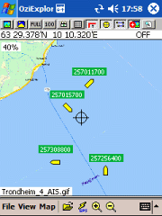
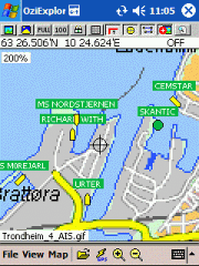
AIS2OZI - AIS2OZI tracks ship positions. It is a logger/decoder/plotter for PocketPC.
Ship positions are plotted directly in OziExplorer Download AIS2OZI (Make backup of Shiplist.txt when reinstalling.)
Decodes AIVDM sentences of types 1, 2, 3 and 5, i.e. position reports for class A shipborne equipment plus vessel information.
Like it? Share with your friends!
If you got an error while installing Themes, Software or Games, please, read FAQ.
Supported operating systems:
Windows Mobile 5.0, Windows Mobile 6 Classic, Windows Mobile 6 Professional, Windows Mobile 6.1 Classic, Windows Mobile 6.1 Professional, Windows Mobile 6.5 Professional
Similar Software:
Locify With Locify you can explore interesting places near you from Wikipedia, seek for geocaches, display map where you are (or you want to go), twitter your location, save interesting places from phone or web sync them and even navigate to them... and much more.
Locify is free application for common mobile phone
RadarGPS Making of radars database and dangerous objects
Xylon GPS Data Logging for the Pocket PC Xylon GPS Data Logging for the Pocket PC - Xylon captures and stores GPS information as required and configured by you. This is true low cost flexible data acquisition, the only requirements being a Pocket PC and GPS capture module. Depending upon your requirements you can use anything from a $60 GPS board to a real time kinetic system
FON Access Points for Guadaloupe FON Access Points for Guadaloupe - FON offers you a new Points of Interest service (POIs). This allows you to download FONspots directly to your navigation device.
What does that mean? You can download a Points of Interest file directly to your navigation device
PictureGPSings PictureGPSings - PictureGPSings can be used when you want to describe a set of pictures/videos from your camera and GPS information. Enter the text to place at the end of the images and the text will appended to the end of the images/videos taken with the GPS information.
This program requires that you have both the 'BeanDLL
G-Watch G-Watch is a stop watch which supports GPS devices. It keeps track of your distance, speed and altitude. G-Watch is a tool which combines following features: stopwatch, countdown timer and geocaching
LocationSMS LocateSMS permit to include your GPS-coordinates into a SMS
TravelReporterer TravelReporterer uses the GPS on your PocketPC to find your current latitude/ longitude/ speed/ altitude and looks up the GPS profile and displays it. Tap the button to start the GPS and when you get the lock tap the button again to view the GPS profile. This service is provided by Geonames
amAze (LG) AmAze is a first of its kind free navigation and local search service. It is free to download and use and it contains wide coverage of maps including aerial photo in Europe, North America, Australia and parts of Asia and Africa
Other Software by developer «Frank Dahlslett»:
not found
Comments on AIS2OZI:
Comments not found
If you noted an error or download link is broken, please, report it via this page or use comments.


")