Supported operating systems:
Windows Mobile 5.0, Windows Mobile 6 Classic, Windows Mobile 6 Professional, Windows Mobile 6.1 Classic, Windows Mobile 6.1 Professional
Similar Software:
SmokeGPSs SmokeGPSs - SmokeGPSs can be used to with GPS to help you to daily reduce the amount you smoke until you quit. For each day the program tracks the GPS location of each time you smoke and the total count for the day. You can also view the entries on a calendar interface.
This program requires that you have both the 'BeanDLL
FindMe by SMS FindMe by SMS - This one works in background and does not alert user that their location is queried. Restarts automatically if phone is power cycled
FON Access Points for Bosnia and Herzegovina FON Access Points for Bosnia and Herzegovina - FON offers you a new Points of Interest service (POIs). This allows you to download FONspots directly to your navigation device.
What does that mean? You can download a Points of Interest file directly to your navigation device
Navio Navio is the perfect companion for your GPS receiver!
Navio gives you access to all the information from your GPS receiver on your Pocket PC 2002/2003/WM5/WM6 device or Windows computer (95/98/NT4/Me/2000/XP)
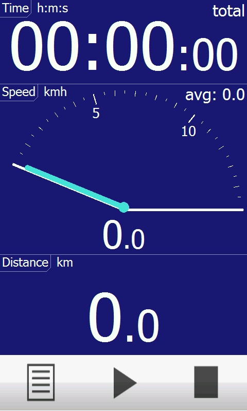
hdSpeedo hdSpeedo is a speedometer that is driven from a GPS signal.
· User configurable background colours
· Day/Night colour schemes (Choose by clicking on the top status bar)
· Rotatable (Portrait or Landscape)
· Gesture enabled (Move between screens)
· Point and Track logging now available as
TravelFTPs TravelFTPs - TravelFTPs can be used when you travel. You can set a FTP server to send a 'picture blog' of your trip. The program creates the HTML page and sends the page and pictures to the FTP server.
This program requires that you have both the 'BeanDLL.dll' file ** and ** the runtime files for Visual Basic on your PocketPC computer
GPRS Connection Manager This application allows you to enable/disable your GPRS connection settings
Navigation BE-ON-ROAD Europe Q2/2011 Navigation BE-ON-ROAD Europe Q2/2011 - The new major version of be-on-road presents new features and is based on new platform which brings high level of reliability, portability and speed on almost any kind of device. The new be-on-road brings high value voice guided door-to-door navigation
GPS Tuner Essentials Full Version with BENELUX Basic Map Content GPS Tuner Essentials Full Version with BENELUX Basic Map Content is designed specifically for off-road use: its large buttons, selectable tool window size, multiple Compass views and the built-in Tele Atlas map makes it extremely user-friendly and reliable
PictureGPS PictureGPS allows you to tag pictures from your PocketPC camera in real time with a GPS stamp and view the distance of each picture via your current GPS. You can use the ruler to view the distance of each picture and also view the GPS stats for each picture with a Google.com map. The map service is provided by Google
Comments on RunSat:
Comments not found
If you noted an error or download link is broken, please, report it via this page or use comments.
RunSat is compatible with your device i-teq X-Bond