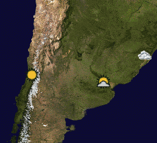
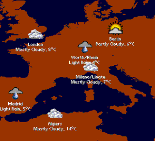
Current weather maps, reports and forecasts - This pack includes two weather maps containing 20 and 50 principal agglomerations of the world: Algiers, Ankara, Athens, Baghdad, Bangkok, Beijing, Berlin, Buenos Aires, Cairo, Caracas, Casablanca, Chennai (Madras), Chicago, Dallas-Fort Worth, Delhi, Dhaka, Guadalajara, Ho Chi Minh City, Hong Kong, Jakarta, Johannesburg, Karachi, Khartoum, Kinshasa, Lagos, Lima, London, Los Angeles, Madrid, Medellin, Metro Manila, Mexico City, Miami, Milan, Moscow, Mumbai (Bombay), Porto Alegre, Rhein-Ruhr North, Rio de Janeiro, Saint Petersburg, San Francisco-Oakland, Santiago (Chile), Seoul, Shanghai, Singapore, Sydney, Tehran, Tokyo, Toronto and Washington D.C.
These two maps require PrettyMap software installed and internet connection on your PDA.
Registered PrettyMap Full users can create weather maps with customized locations (e.g. cities of interest).
What's New in This Release:
· upgraded to conform with versions 4.x of PrettyMap
Like it? Share with your friends!
Supported operating systems:
Palm OS 3.x, Palm OS 4.x, Palm OS 5.x
Similar Software:
Infuzer weather With Infuzer you can get a free five-day weather forecast, automatically updated up to four times a day for over 45,000 locations around the world!
Weather Companion Pro Weather Companion Pro is a GPRS based high-end software that brings weather information from internet for all major cities in the world
4cast 4cast displays today's weather & next 4 days' weather forecast, with auto-update & radar maps.
· Downloads weather information from weather.yahoo.com
· Displays forecast for the next 5 days, and details (e.g. wind, humidity, text forecast ..
Weather Forecast Browser Weather Forecast Browser - Weather Forecast Browser (also known as WFBrowser) – is offline browser for weather forecast web sites. In current version all information gets from http://weather.yahoo.com. WFBrowser allows check forecast information in offline on closest 5 days
TealInfoDB: World Temperatures TealInfoDB: World Temperatures sia folio containig average monthly temperatures for selected cities all over the world. Also shows longitude and latitude
TealInfoDB: Air Toxics TealInfoDB: Air Toxics - toxic air pollution levels for over 1,800 compounds
Weather Calculator for Palm OS Weather Calculator for Palm OS converts temperature, wind and pressure and calculates wind chill, heat index, relative humidity and standard atmosphere.
Tables of Fujita Tornado Scale, Saffir Simpson Hurricane Scale and Beaufort Wind Force Scale
Hurricane Tracker Hurricane Tracker - Born out of a need to keep abreast of what the latest tropical depression/tropical storm/hurricane is doing, I created Tracker, a Palm OS application for keeping up with the whereabouts of the latest storm
Forgot Something? Forgot Something? - You will never lose anything anymore while going on a trip with this application
Other Software by developer «Maciej Komosinski»:
Vector Maps for PrettyMap Vector Maps for PrettyMap - This pack contains the most popular vector maps for PrettyMap
PrettyMap View maps of Earth and other planets with PrettyMap! See current day and night areas, learn geography with the quiz, enjoy 3D elevation relief, measure distances, edit locations!
Top Sailor (iPhone/iPad) Top Sailor (iPhone/iPad) - Top Sailor is a highly realistic sailing and motorboat simulator. Take Top Sailor with you and learn basics of sailing! See how wind force affects the sail and test your skills against AI opponents in a yacht race. Learn how to trim the sails to make the most use of wind energy. Discover when there is a risk of capsizing
PrettyMap Full View maps of Earth and other planets with PrettyMap! See day and night areas, learn geography, enjoy 3D elevation surfaces, measure distances and create your own maps with special places!
Little Sailor (iPhone/iPad) Little Sailor (iPhone/iPad) - Little Sailor is a highly realistic sailing and motorboat simulator. Take Little Sailor with you and learn basics of sailing! See how wind force affects the sail and test your skills against AI opponents in a yacht race. Learn how to trim the sails to make the most use of wind energy. Discover when there is a risk of capsizing
Free Earth Elevation Map for PrettyMap/PrettyEarth Earth Elevation Map for PrettyMap/PrettyEarth - This is a medium-resolution, free Earth elevation map for PrettyMap and PrettyEarth. It contains one elevation sample per 4 km, approximately.
Note: large file (16 MB download, 55 MB after installing).
Note for PrettyEarth users: this map will be installed to Program FilesPrettyMapmaps
Europe Elevation Maps Europe Elevation Maps - This free pack contains high resolution elevation map for Europe, divided into 2 smaller pieces. Each tile covers the projected area of 40°x50°, and contains almost 29 million of samples (one sample per square kilometer).
51 countries lie in the area covered by this pack


")

")


