GPS Status & Toolbox - Be a GEEK: Get the most out of your phone. Raw GPS data at your fingertips.
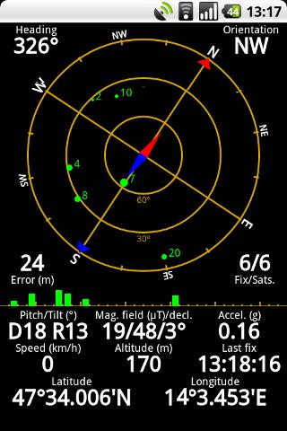
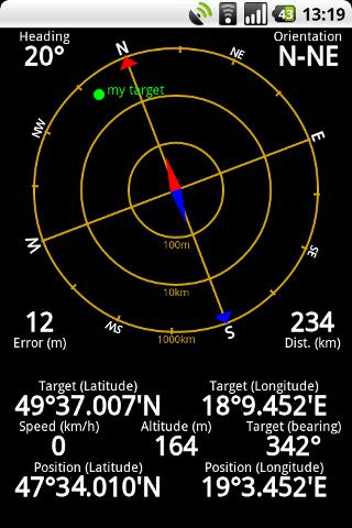
Display your GPS and sensor data: position and signal strength of satellites, accuracy, speed, acceleration, bearing.
Tools included: compass with magnetic and true north, leveling tool, mark or share your location and navigate back later.
Keep your GPS fast: reset it or download A-GPS data regularly for faster fixes.
What's New in This Release:
· Workaround for Nexus S issues.
· aGPS age is correctly displayed (in hours / days).
· Fixed a rounding error in location formatting.
· More instruments for Nexus 7.
· Enhanced landscape layout. All instruments are available in landscape mode, too!
Like it? Share with your friends!
Supported operating systems:
Google Android 1.0, Google Android 1.5, Google Android 1.6, Google Android 10.x, Google Android 2.0, Google Android 2.1, Google Android 2.2, Google Android 2.3, Google Android 3.0, Google Android 3.1, Google Android 3.2, Google Android 4.0, Google Android 4.1, Google Android 4.2, Google Android 4.3, Google Android 4.4, Google Android 5.x, Google Android 6.x, Google Android 7.x, Google Android 8.x, Google Android 9.x
Similar Software:
MileageLedger 2.0 MileageLedger 2.0 - New features include resume trip, filtered reports, auto data export, data export via e-mail or SD card, improved GUI, increased reliability & accuracy, fault tolerance, & trip categories
Mileage Ledger is a GPS powered mileage logging application designed for Android enabled smart phones
iTrack iTrack is an application for tracking your friend's location in real time. You and your friend must both install this application. Click menu to show current online users; Click your friend and make a request. Your friend will be notified and respond to your request. The map will be updated in real time if your friend allows tracking
CoPilot Live Europe (Android) CoPilot Live Europe (Android) - CoPilot Live is full-featured voice-guided GPS navigation with Western and Eastern Europe street maps stored on your phone. Includes 3D guidance, lane assist, speed limit warnings, safety camera alerts, planning mode.
Download maps via WiFi after purchase. Unlimited use after 10 days once Google order verified
Wireless Info Wireless Info - Want to know more of your GPS, Phone, Wifi and Bluetooth facility. This application will display data like wifi freq, signal strength, no of satellites, bluetooth devices in vicinity etc
NAVIGON Australia for Android NAVIGON Australia for Android - NAVIGON turns your mobile device into a fully featured GPS navigation system. The software provides advanced functionality for both drivers and pedestrians, including 2D and 3D maps, route planner, speed assistant, voice directions, local search, and more
wayg wayg - Create your trip, record your route, share your position. WhereAreYouGoing is able to record position, speed, altitude and time of your routes on your device. WhereAreYouGoing allow to share your route on the most important social network (Google+, Twitter, Facebook...), create file Kml for Google Maps or file GPX (OpenStreetMap)
Geo note Geo note - is an organizing application for Android device users which takes into consideration your current location. When you are in a certain place your smartphone will remind you about coming event or task to complete
Run.GPS Trainer UV Run.GPS Trainer is the perfect tool for sports like running, skiing and walking. It uses the Global Positioning System (GPS) to record all of your training parameters like speed, distance and altitude.
Run.GPS Trainer UV is the successor of of the award-winning Run.GPS Trainer software and has tons of new features
amAze (Motorola) AmAze is a first of its kind free navigation and local search service. It is free to download and use and it contains wide coverage of maps including aerial photo in Europe, North America, Australia and parts of Asia and Africa
GPS Odometer GPS Odometer - A simple and easy to use odometer. There is no maze of menus and no mysterious settings. GPS Odometer only does one thing, and does it well: measure distance traveled.
Note: Intended to measure relatively short distances, the application does not run in the background
Other Software by developer «EclipSim Bt.»:
Hungarian for AnySoft Keyboard Kenyelmesen, magyarul irhat az Anysoft Keyboard segitsegevel. Magyar billentyűzet kiosztas es szotar AnySoftKeyboard-hoz. FIGYELEM! Ez egy kiegeszitő, ami csak az eredeti programmal egyutt műkodik. Onalloan nem!


")


")

