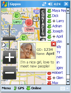
Gippos is mobile software for locating yourself and other users on the map and for instant messaging. Feel the city pace
Do you like to meet new people on the streets? Chat with them for free? Know where your friends are?
Meet and communicate without trouble! Enjoy nature
Arranging a picnic in a beautiful place? Inviting your friends for a country walk? Your friends will easily find you on a map!
· Find your friends on a map
· Meet new people around you
· Chat for free
What's New in This Release:
· Jabber protocol is used for messaging now.
· Jabber users from other servers can be added to contact list.
· Loading last messages to chat log window is added.
· Chat history viewing is added.
· Avatar loading is added.
· "About Gippos" info window is added.
· Maps switching logic is improved.
· Three modes of user's location visibility are implemented.
· New chat statuses are added.
· Gippos auto updating at new version release is added.
· "Don't turn the device off while the application is running" feature is implemented.
· Viewing user's location, history, and profile from chat window is added.
· Manually locating oneself on the map is added.
· Search window interface is changed
Like it? Share with your friends!
If you got an error while installing Themes, Software or Games, please, read FAQ.
Supported operating systems:
Windows Mobile 5.0, Windows Mobile 6 Classic, Windows Mobile 6 Professional, Windows Mobile 6.1 Classic, Windows Mobile 6.1 Professional, Windows Mobile 6.5 Professional
Similar Software:
Travel Hamburg, Germany - Illustrated Guide, Phrasebook and Maps. FREE general info, map in trial Travel Hamburg, Germany - Illustrated Guide, Phrasebook and Maps. FREE general info, map in trial - An illustrated city guide, phrasebook, and maps. Indulge Yourself with a personal tour guide on Your PDA. FREE General chapter, basic phrasebook, and a map in the trial version.
Features
Fully illustrated.
Historical overviews
TravelAddresses TravelAddresses - This program allows you to enter or paste an address and city, state, country etc. and then searches the Live.com online maps for a map with the address centered in the middle of the map. NOTE: You need an internet connection to use this program.
This program requires that you have both the 'BeanDLL
CartoType Demo (Windows Mobile) CartoType A simple map viewer using the CartoType library.
The program is installed in the folder My Device/Program Files/CartoType. Click on the CartoTypeDemo icon to run the program, then select Open Map.. from the menu to open a map. A map of Berlin is supplied as a sample.
Apart from the menu commands, you can zoom in by pressing the joystick or rolling ball
amAze (LG) AmAze is a first of its kind free navigation and local search service. It is free to download and use and it contains wide coverage of maps including aerial photo in Europe, North America, Australia and parts of Asia and Africa
Map of Lyon / France for City Advisor Map of Lyon / France for City Advisor. This map includes: 4 Metro, 4 Tramway, 2 Funiculaire, 1 Rhonexpress and 2 Bus.
Instructions:
1. Download the map (zip file)
2. Extract the files in /CityAdvisor/maps
3. Open CityAdvisor -> Maps icon -> Menu -> Refresh
4
Bing Bing -Maps, directions, and local listings for your mobile device.
Get local:
· Quickly find great local shops and restaurants, complete with ratings, reviews, hours, and directions.
· See movie show times and call to buy your ticket.
· Get the latest local weather forecasts
TravelMapperer TravelMapperer - TravelMapperer can be used when you travel and need to download offline maps via GPS. The program gets your GPS and downloads 100 maps north/south/east/west from your GPS from Google.com maps and places a GPS tag on them. You can view the maps offline via GPS distance.
This program requires that you have both the 'BeanDLL
Free Earth Elevation Map for PrettyMap/PrettyEarth Earth Elevation Map for PrettyMap/PrettyEarth - This is a medium-resolution, free Earth elevation map for PrettyMap and PrettyEarth. It contains one elevation sample per 4 km, approximately.
Note: large file (16 MB download, 55 MB after installing).
Note for PrettyEarth users: this map will be installed to Program FilesPrettyMapmaps
Travel Ireland - illustrated guide and maps. Incl: Dublin, Cork, Galway and more. FREE General Info Travel Ireland - illustrated guide and maps. Incl: Dublin, Cork, Galway and more. FREE General Info - An illustrated guide and maps. Indulge Yourself with a personal tour guide on Your PDA. FREE General Information chapter and a map in the trial version.
Features
Fully illustrated.
Historical overviews.
Interesting facts.
City Attractions
Google Maps Mobile Google Maps Mobile - Cruising around looking for a nearby coffee shop? Driving to that new restaurant but can't remember which street to turn right on? Now you can get business locations, maps and directions while you're on the go. And it's all free.
Real-time traffic
See where the congestion is, and estimate delays in over 30 major US metropolitan areas
Other Software by developer «Gippos»:
not found
Comments on Gippos:
Comments not found
If you noted an error or download link is broken, please, report it via this page or use comments.
Gippos is compatible with your device Intermec CS40 QWERTY / Numeric


")
")


