GPS NUT - GPS NUT is a GPS logger allowing you to log GPS tracks while you hike, bike, or drive. Also, load waypoints planned on Google Earth in the KML format to help guide you on to your destinations.
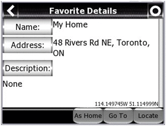
GPS NUT allows you to save GPS waypoints with detailed information to help you find anything. You can store the location of your car in a large parking lot or share the location of a scenic view with others using Google Earth.
· Save GPS logs in Google Earth's KML format.
· Save and Load detailed GPS waypoints in KML format.
· "Locate" items in an hour or a year from now. Find your car in a large mall parking lot or the perfect view atop a nearby mountain. GPS NUT will point to any stored location.
Like it? Share with your friends!
If you got an error while installing Themes, Software or Games, please, read FAQ.
Supported operating systems:
Windows Mobile 6 Classic, Windows Mobile 6 Professional, Windows Mobile 6.1 Classic, Windows Mobile 6.1 Professional, Windows Mobile 6.5 Professional
Similar Software:
EmailGPSeds EmailGPSeds - EmailGPSeds allows you to build email lists and update a person or all of the people on the list your current GPS with a Google.com map as an attachment. You can send the alert to just one email contact or all on the list. The email has a URL of your GPS from the Google.com.
This program requires that you have both the 'BeanDLL
ExcelGPSs ExcelGPSs - ExcelGPSs can be used to make Excel sheets with a GPS tag as the sheet file name. Each time you make a sheet the sheet is named the latitude and longitude of the file. You can store your files on the storage card. You can also view the Excels with Google maps.
This program requires that you have both the 'BeanDLL
Terracrosser Terracrosser is a free GPS navigation software for Windows Mobile Pocket PC.
· Terracrosser works in Map and Photo modes
· Terracrosser uses zoomable maps
· Terracrosser is completely compatible with Google Maps service. With included Mapper module you can download maps from the Internet
FON Access Points for Palestinian Territory FON Access Points for Palestinian Territory - FON offers you a new Points of Interest service (POIs). This allows you to download FONspots directly to your navigation device.
What does that mean? You can download a Points of Interest file directly to your navigation device
MapDrawerer MapDrawerer allows you to download a Google.com map of your current GPS and edit it with a full-featured drawing tool. You can draw on the map and also insert text into the maps as well as use the drawing tools. The JPEG libraries are from Independent JPEG Group. The map service is provided by Google
RulerGPSer RulerGPSer - RulerGPSer uses the GPS on your PocketPC to view and download GPS marked satellite camera pictures and calculates distance between two points specified by the latitude/longitude of your GPS using "The Vincenty inverse formula for ellipsoids." (accuracy to within 0.5mm, or 0.000015")
This program requires that you have both the 'BeanDLL
GParkS The other day I was at a football game where I had to park on a golf course far from the stadium and ended up wandering around for 20 minutes trying to locate the car afterward
mySearch mySearch is a location-aware search application that uses Microsoft Bing to return results based on your current position. Just enter in your search term and press the search button to return location specific results!
If your device has HTC's G-Sensor service then simply orient the screen for landscape or portrait mode
FON Access Points for Japan FON Access Points for Japan - FON offers you a new Points of Interest service (POIs). This allows you to download FONspots directly to your navigation device.
What does that mean? You can download a Points of Interest file directly to your navigation device
FON Access Points for Ireland FON Access Points for Ireland - FON offers you a new Points of Interest service (POIs). This allows you to download FONspots directly to your navigation device.
What does that mean? You can download a Points of Interest file directly to your navigation device
Other Software by developer «Novlum»:
not found
Comments on GPS NUT:
1adam12:
fails to install on palm treo 800w
Date: 12 Jul 11
If you noted an error or download link is broken, please, report it via this page or use comments.
GPS NUT is compatible with your device Intermec CS40 QWERTY / Numeric