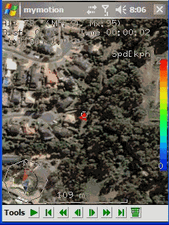
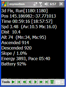
MyMotion - GPS route recording and playback with customizable spoken feedback of speed, distance and time. Uses a moving map to show progress as well as textual output. Maps can be generated from Google Earth installed on a PC using a map creation tool. Allows user to record a route then load it up as a reference for live comparison the next time it is traversed. Optional location tracking of GPS devices with GPRS or 3G, via the web and Google Earth or Google Maps.
· This software is free for personal use.
What's New in This Release:
· Performance Improvements, particularly UI responsiveness.
· User definable default file name format for track save.
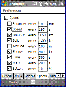
· Add sensitivity enabling for menu items.
· Bug fixes: Fixed arrow direction. Fixed corruption with long (> 32 chars) file names in track files.
Like it? Share with your friends!
If you got an error while installing Themes, Software or Games, please, read FAQ.
Supported operating systems:
Windows Mobile 2003, Windows Mobile 5.0, Windows Mobile 6 Classic, Windows Mobile 6 Professional, Windows Mobile 6.1 Classic, Windows Mobile 6.1 Professional, Windows Mobile 6.5 Professional
Similar Software:
GPS Tracker GPS Tracker is a part of a fleet management software system, which is used to track mobile phone activity (e.g. mobile phone can be used as a gps tracking device).
The application will monitor the GPS activity and it will send the data to the http://voznipark.virtualniured.hr online server
TravelFTPs TravelFTPs - TravelFTPs can be used when you travel. You can set a FTP server to send a 'picture blog' of your trip. The program creates the HTML page and sends the page and pictures to the FTP server.
This program requires that you have both the 'BeanDLL.dll' file ** and ** the runtime files for Visual Basic on your PocketPC computer
GPSWM65Voice GPSWM65Voice creates GPS stamped wave files and displays them in an easy to use explorer interface. When you get a GPS lock, the app will display the wave files in order of distance to your current location. To re-play the wave file simply tap on it. The map service is provided by Google
FON Access Points for Senegal FON Access Points for Senegal - FON offers you a new Points of Interest service (POIs). This allows you to download FONspots directly to your navigation device.
What does that mean? You can download a Points of Interest file directly to your navigation device
e-Mobile GPS Traffic e-Mobile GPS Traffic
Receive real-time traffic information from your hand. Get all you need to know about the traffic condition around town.
Live traffic flow and traffic incidents report.
Get directions and traffic conditions to a point of interest with detailed map
RaceChrono RaceChrono is a GPS based lap timing software for Windows Mobile. It can be used to measure lap times on almost any vehicle and track. It can be used to measure laptimes for example for motorbikes, bicycles, cars, water jets and quadbikes.
What's New in This Release:
· Much better looking user interface.
· Better and simplified touchscreen usage
PictureGPS PictureGPS allows you to tag pictures from your PocketPC camera in real time with a GPS stamp and view the distance of each picture via your current GPS. You can use the ruler to view the distance of each picture and also view the GPS stats for each picture with a Google.com map. The map service is provided by Google
IndicatorSpeed IndicatorSpeed uses the GPS on your PocketPC to find your speed and displays it on the task bar of any running PocketPC application. Select Km/Miles or NM and tap the button to start the GPS. The program reports your GPS chip GPRMC speed (Very accurate)
TravelWiFier TravelWiFier - TravelWiFier can be used to log WiFi hotspots via GPS. Each time you find a hotspot you can create a new 'WiFi' file with the current GPS and login information. When you are traveling the program uses the GPS on your PocketPC to find the closest WiFi hotspot and displays the distance.
This program requires that you have both the 'BeanDLL
GPS Tuner Essentials Full Version with Canada Basic Map Content GPS Tuner Essentials Full Version with Canada Basic Map Content is designed specifically for off-road use: its large buttons, selectable tool window size, multiple Compass views and the built-in Tele Atlas map makes it extremely user-friendly and reliable
Other Software by developer «Ian Pendlebury»:
not found
Comments on MyMotion:
Comments not found
If you noted an error or download link is broken, please, report it via this page or use comments.
MyMotion is compatible with your device Intermec CS40 QWERTY / Numeric