GPS4PPC is an open source application, written with Basic4ppc that includes a set of tools for navigation and GPS data.
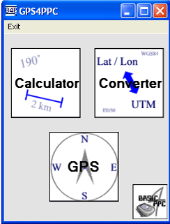
GPS4PPC supports:
- Converting coordinates between UTM and Lat / Lon.
- Converting coordinates in different datums.
- Calculating the distance and course between two coordinates.
- Show GPS data.
- Animated compass.
- Built-in numpad for fast and easy input.
Like it? Share with your friends!
If you got an error while installing Themes, Software or Games, please, read FAQ.
Supported operating systems:
Windows Mobile 5.0, Windows Mobile 6 Classic, Windows Mobile 6 Professional, Windows Mobile 6.1 Classic, Windows Mobile 6.1 Professional, Windows Mobile 6.5 Professional
Similar Software:
OakLogMobile OakLogMobile - Logger application for your Windows Mobile device. Records GPS and sensor information on your phone.
The log files (*.olg) can later be loaded into TrackView.NET and viewed in all their 3D-glory.
Just copy the .exe-file onto your device manually and run it via the file explorer.
· Logs GPS position, altitude, speed, etc
SportyPal SportyPal is an easy to use intuitive application for your mobile device. You activate it when you start your running, cycling, walking, rollerblading or similar exercise. In two simple clicks it will start to log and map your position, movement, distance, tempo and calories burned
myRadar myRadar is a location aware radar application that makes use of Wunderground and Accuweather US web services to show real-time, animated Radar Images of your local area regardless of where in the US you might be. This application requires myLocation services to function automatically.
The program will install to /Program Files/myRadar
BikeTrack BikeTrack - This application enables everybody (who got your user/pass) look up your location on the net, using your the page http://fiets.galway.nl/ and keeps track of you.
On the webpage you can also create a username so you can use the software.
What it does:
- Gets location from GPS.
- Sends it to BikeTrack Server
FON Access Points for Canada FON Access Points for Canada - FON offers you a new Points of Interest service (POIs). This allows you to download FONspots directly to your navigation device.
What does that mean? You can download a Points of Interest file directly to your navigation device
Marathon Marathon is a Windows Mobile application which keeps track of your movement with the help of a GPS-receiver. It is the perfect companion for sporting activates such as running, skiing or ice skating.
You can configure Marathon to announce various statistics in the headset or speaker while you’re recording
SafetyRide SafetyRide Limiting the scope of searches in case of emergency, this mobile application helps people who need to walk in dangerous places. Keeping a GPS connection and sending SMS to a configured number with the latest position at determined intervals
amAze (Sony Ericsson) AmAze is a first of its kind free navigation and local search service. It is free to download and use and it contains wide coverage of maps including aerial photo in Europe, North America, Australia and parts of Asia and Africa
CellGPSer CellGPSer uses the cellular signal on your device to instantly find your approximate GPS. Tap the button while your phone is on and the program will send your cellular tower information to OpencCellID.org. The program will then display the approximate GPS. This service is provided by OpenCellID
MapsAligner MapsAligner - MapsAligner allows you to download large maps based on your GPS or with custom latitude and longitude points that you enter. You can use this to compose maps for your GPS applications. The program uses the Google.com maps server for the maps.
This program requires that you have both the 'BeanDLL
Comments on GPS4PPC:
Comments not found
If you noted an error or download link is broken, please, report it via this page or use comments.
Attention! GPS4PPC may be not compatible with your device Intermec CS40 QWERTY / Numeric


")

