mdNavMobile is a waypoint-based GPS navigation solution for the Windows Mobile platform. It can guide you from waypoint to waypoint while keeping you informed of all relevant navigation data. All NMEA-data from a GPS is automatically logged to file so you can 'replay' a trip with variable speed.
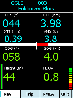
· GPS info: Latitude, Longitude, COG, SOG, Height, Satellites, HDOP and NMEA-stream
· Waypoint info: CTS, DTG, TTG, VMG, XTE
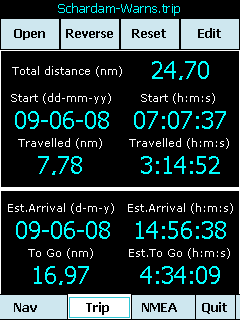
· Trip info: Total distance, Start, Travelled distance/time, DTG, TTG, ETA
· Reverse and Reset trips
· Scroll to next/previous waypoint
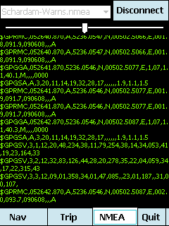
· Logs full NMEA stream from GPS to Storage Card
· Simulation using NMEA-log files with variable speed (factor 0.01-100)
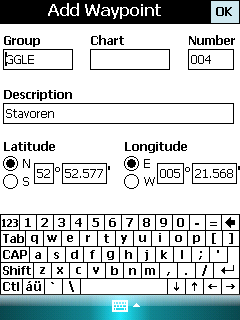
· Create/Edit Trips and Waypoints
· Show data in nm/kts/ft or km/kmh/m
· Change colors
· Trip-files also editable with notepad
· Totally free
Like it? Share with your friends!
If you got an error while installing Themes, Software or Games, please, read FAQ.
Supported operating systems:
Windows Mobile 5.0, Windows Mobile 6 Classic, Windows Mobile 6 Professional, Windows Mobile 6.1 Classic, Windows Mobile 6.1 Professional, Windows Mobile 6.5 Professional
Similar Software:
Visitor Guide Metro+ Amsterdam Visitor Guide Metro+ Amsterdam is a route planner for the Metro, Tram and local National Rail network of Amsterdam. It consists of two maps:
The Metro and local National Rail network of Amsterdam
The Tram of Amsterdam.
Other Cities available
busGuide2 busGuide2 is a Windows Mobile application to get the bus arrival timing of SBS buses at different bus stops in Singapore.
This is an upgrade to the previous busGuide application and has an improved UI. SMRT supported bus stops are now highlighted and bus numbers are color coded to differentiate SMRT and SBS busses
SciLors Fahrplanauskunft SciLor's Fahrplanauskunft is a tool for searching timetables for bus and trains in germany over VRR.de and Deutsche Bahn.
You can save those plans and take a look on them offline
My Traffic Updates My Traffic Updates is an application that enables users to check live (almost) traffic conditions.
Currently this version is only checking information available from LLM and ITIS for Malaysia.
WARNING ! This application is accessing data from internet. It's best to have unlimited data plan to avoid heavy charges
SBS Bus Time SBS Bus Time-Get bus arrival timing for buses in Singapor.
Install Instruction
Download the .wgt file and transfer it to your phone
Install it using File Manager like when your installing a .cab file
Samsung Phone i.e. OMNIA II
Install total commander or other file manager.
Browse to the location where the
Metro Melbourne Metro Melbourne - Riding Melbourne's train system? Tired of having to carry around train timetable booklets in your pocket? Want to quickly find out arrival and departure time for any train in Melbourne? Metropolitan Melbourne has the answer for you.
Metropolitan Melbourne ("Metro Melbourne" for short) is an application for Windows Mobile phones
Travel To Greece Travel To Greece - Every year, over 4 million of tourists are travelling to Greece. If you are one of the lucky tourists, you will find the ?Travel to Greece? application the most useful, exciting and valuable application. It is not a simple limited travelling guide
Fizz Traveller .Fizz { font-family: Arial; font-size: 8pt; }.style1 { font-family: Arial,Helvetica,sans-serif; color: rgb(51, 51, 51); font-size: 12px; }
Fizz Traveller 3.0 is the next generation of the Award Winning Fizz Traveller program. With Fizz Traveller 3
Other Software by developer «Maurits Dijkens»:
not found
Comments on mdNavMobile:
Comments not found
If you noted an error or download link is broken, please, report it via this page or use comments.
mdNavMobile is compatible with your device Intermec CS40 QWERTY / Numeric