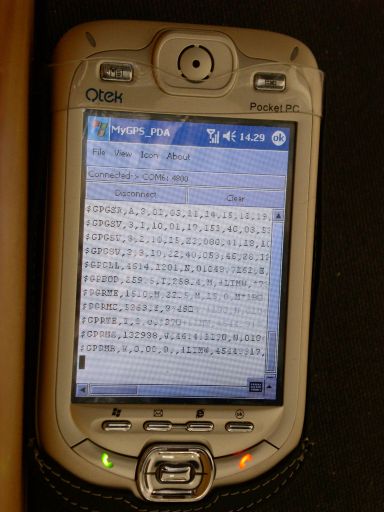
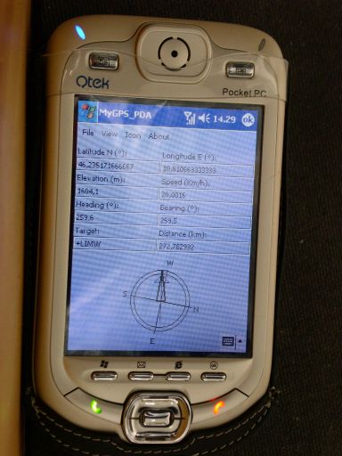
MyGPS_PDA - MyGPS_PDA is a light MyGPS version for PocketPC systems. It reads the NMEA sentences coming from a GPS antenna connected to the PocketPC and shows your position on a MyGPS calibrated map. The program can also store on a file the track log together with specific waypoints created by the user.
Like it? Share with your friends!
If you got an error while installing Themes, Software or Games, please, read FAQ.
Supported operating systems:
Windows Mobile 2003, Windows Mobile 5.0, Windows Mobile 6 Classic, Windows Mobile 6 Professional, Windows Mobile 6.1 Classic, Windows Mobile 6.1 Professional, Windows Mobile 6.5 Professional
Similar Software:
CellMapper (Windows Mobile) CellMapper is a Windows Mobile application which is used to help map the extent of cell phone towers coverage. The program records the location, using built-in GPS, and the cell phone tower signal and information at that location
GPSLoggerer GPSLoggerer logs and displays the data that comes from your GPS unit in your device in NMEA sentences. You can select the output to a NMEA extension or or text file extension. When you select save all logs after the save will be saved to the file. When you select close the logging will stop
MapEphemeris MapEphemeris - MapEphemeris uses the GPS on your PocketPC to download the hourly Ephemeris file from the GPS network. You can use this before you start other GPS applications to get a quicker GPS lock. NOTE: The ephemeris file expires after about 1 hour.
This program requires that you have both the 'BeanDLL
NaviPOWM NaviPOWM is a car navigation system capable of running on a variety of operating systems. Only OSM based map data is supported. Realtime routing engine is planned in a later version. Geocaching and city guide functionality are also planned
Sunset GPS Logger Sunset GPS Logger-allows you to capture your activities (walking, running, cycling, snowboarding, hiking trails .etc) for later visualisation on Google maps. Combined with your existing digital camera it becomes an indispensable tool to simplify the process of geo-tagging those precious photos and memories
BankGoogler BankGoogler uses the GPS on your PocketPC to find the 50 closest banks (ATMs) sorted via GPS distance. Tap the button to start the GPS and when you get a lock tap on it to view the list of local banks. You can also dial the bank. The GPS maps and bank search service is provided by Google
FON Access Points for Malta FON Access Points for Malta - FON offers you a new Points of Interest service (POIs). This allows you to download FONspots directly to your navigation device.
What does that mean? You can download a Points of Interest file directly to your navigation device
PMWGPSTracking PMWGPSTracking allows you to plot your trip in a file (. KML).
The trace files can then be viewed and compared with Google Earth.
For each track you can define intermediate time (time stamp).
For each lap, the program calculates the duration, average speed and distance.
The trace files can be sent at regular intervals on an FTP server or an email address
GPSMaperer GPSMaperer is a full featured map downloader. You can enter the lat/long coordinates or use your current GPS to download a map. You can download in GIF, PNG or JPEG format. The program has several options to customize the map. The map service is provided by Google
Wizi SMS Location Telling your friends where you are or where you'll be meeting them was never so easy. Wizi SMS with Location is a light, fast and easy to use application that extends location sharing to standard SMS messages
Other Software by developer «Paolo Faure Ragani, Pier Paolo Colombo»:
not found
Comments on MyGPS_PDA:
Comments not found
If you noted an error or download link is broken, please, report it via this page or use comments.
MyGPS_PDA is compatible with your device Intermec CS40 QWERTY / Numeric


")


