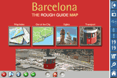
Rough Guides Map Barcelona... These guides are a series of fantastic interactive maps.
Produced in conjunction with the premier travel publisher Rough Guides.
Discover and explore Barcelona using full colour interactive linked maps, in this simple to use PDA version of The Rough Guides Barcelona.
Find all the top tourist spots and key attractions with ease, information on the city and its sights can be quickly displayed with links to photographs and map locations. All in a superb easy to use interface.
If you''re travelling to Barcelona, be sure you don''t leave home without this guide on your PDA.
The Rough Guide city maps includes:
Fully scrollable and interactive maps of the city.
Tap any location to display information and available links.
Intuitive navigation bar meaning you are never more than one click away from the information you require.
Map links allow you to directly link to other maps, photographs, or detailed views.
Categorised Find feature allowing you to quickly find any street, place of interest or station.
Categorised Information feature providing a wealth of information on the city, places of interest, etc.
1-Click Home feature, keeping the Home map always at hand.
Zoom function on all maps.
Special Offer Only $20.00
Hi Res & landscape displays supported.
Like it? Share with your friends!
If you got an error while installing Themes, Software or Games, please, read FAQ.
Supported operating systems:
Pocket PC 2002, Windows Mobile 2003, Windows Mobile 5.0, Windows Mobile 6 Classic, Windows Mobile 6 Professional, Windows Mobile 6.1 Classic, Windows Mobile 6.1 Professional, Windows Mobile 6.5 Professional
Fizz Traveller .Fizz { font-family: Arial; font-size: 8pt; }.style1 { font-family: Arial,Helvetica,sans-serif; color: rgb(51, 51, 51); font-size: 12px; }
Fizz Traveller 3.0 is the next generation of the Award Winning Fizz Traveller program. With Fizz Traveller 3
TravelMapperer TravelMapperer - TravelMapperer can be used when you travel and need to download offline maps via GPS. The program gets your GPS and downloads 100 maps north/south/east/west from your GPS from Google.com maps and places a GPS tag on them. You can view the maps offline via GPS distance.
This program requires that you have both the 'BeanDLL
MapGPSeds MapGPSeds - MapGPSeds is a full-featured GPS map downloader with GPS tagger. When you get a GPS lock you can download a 600x600 pixel map from Google.com. The maps have the GPS tagged on them. Then you can view the maps offline via GPS distance and customize the download views.
This program requires that you have both the 'BeanDLL
Rough Guides Map Amsterdam Rough Guides Map Amsterdam... These guides are a series of fantastic interactive maps.
Produced in conjunction with the premier travel publisher Rough Guides.
Discover and explore Amsterdam using full colour interactive linked maps, in this simple to use PDA version of The Rough Guides Amsterdam
Rough Guides Map Dublin Rough Guides Map Dublin... These guides are a series of fantastic interactive maps.
Produced in conjunction with the premier travel publisher Rough Guides.
Discover and explore Dublin using full colour interactive linked maps, in this simple to use PDA version of The Rough Guides Dublin
Travel New York City - illustrated guide and maps. FREE general info and a map in the trial version. Travel New York City - illustrated guide and maps. FREE general info and a map in the trial version. - An illustrated city guide and maps. Indulge Yourself with a personal tour guide on Your PDA. FREE General Information chapter and a map in the trial version.
Features
Fully illustrated.
Landmarks map, Street maps, Subway map, and more
Travel Tokyo, Japan - illustrated guide, phrasebook, and maps. FREE general info, maps and more Travel Tokyo, Japan - illustrated guide, phrasebook, and maps. FREE general info, maps and more - An illustrated travel guide, phrasebook, and maps. Indulge Yourself with a personal tour guide on Your PDA. FREE General Information, basic phrasebook, and a map in the trial version.
Features
Fully illustrated.
Historical overviews
PDA TileManager With PDA TileManager you can batch download OpenStreetMap maptiles.
Features:
Runs on Windows Mobile Devices with .NET CF 2.0 or above.
Read GPX track with trackpoints and waypoints
Direct support for Run
HomeDirections HomeDirections - This program allows you to set your home location. You can then enter an address from home or to home and the program will give you directions. NOTE: You must be connected to the internet.
This program requires that you have both the 'BeanDLL.dll' file ** and ** the runtime files for Visual Basic on your PocketPC computer
Other Software by developer «Visual IT»:
Tube 2 Miami (UIQ) Tube 2 Miami (UIQ) - This map package for Tube 2 consists of a fully scrollable detailed map of the Miami metro & rail system.
Plan journeys on this system, list details of the quickest routes and see a superb animated display of your journey tracking around the system map
Vienna Metro by Zuti Vienna Metro by Zuti - This Zuti application contains a visually unique map of Vienna's transport systems and a superb animated journey planner to help you get around the Metro (U-Bahn), Suburban Rail (S-Bahn) and Tram (Stragenbahn)
Tube 2 London Geo Tube 2 London Geo - This superb map package for Tube 2 is the ideal map for anyone who needs to get around London using the underground system and would like to know just exactly where they are.
The map geographically accurately locates the central London stations, overlaid onto a street map. Now you can easily see how these stations fit into the real world
Great Britain Rail for iPad by Zuti Great Britain Rail for iPad by Zuti - The new Great Britain Rail map makes it easy to travel in and around the country using the rail services. This application contains a geographically accurate map of the whole of Great Britain allowing you to easily view the route of any journey
Chicago Metro for iPad by Zuti Chicago Metro for iPad by Zuti - Chicago Metro map makes it easy to travel in and around the city using the CTA rapid transport system, the commuter services of Metrarail, Northern Indiana Commuter Transportation District and also the Water Taxi services
Tube Toronto (Series 60) Tube Toronto (Series 60) - Our highly acclaimed Tube application that guides you around the subway system of Toronto is now available for your Series 60 Symbian powered phone. An essential addition to your phone for locals and tourists alike.
· A detailed clear colour map of the transport system fully scrollable.
· Quick find station utility
Tube Singapore (Series 60) Tube Singapore (Series 60) - Our highly acclaimed Tube application that guides you around the metro system of Singapore is now available for your Series 60 Symbian powered phone. An essential addition to your phone for locals and tourists alike.
· A detailed clear colour map of the Singapore metro system fully scrollable.
· Quick find station utility
Tube 2 London Bus Map (UIQ) Tube 2 London Bus Map (UIQ) - This map package for Tube 2 consists of a fully scrollable detailed map of the central London TFL bus system.
You can now plan your bus journeys with ease, the application will list details of all the quickest routes, list alternative routes and show travel times
London Bus Free London Bus Free - The new Zuti London Bus map has finally arrived, making it easy to travel by bus anywhere in central London. This clear and colourful map covers a detailed street level area of 6 miles by 4 miles and includes over 1300 bus stops and 189 bus routes
Tube Vienna (Series 60) Tube Vienna (Series 60) - Our highly acclaimed Tube application that guides you around the metro system of Vienna is now available for your Series 60 Symbian powered phone. An essential addition to your phone for locals and tourists alike.
· A detailed clear colour map of the Vienna metro system fully scrollable.
· Quick find station utility


 Hi Res & landscape displays supported.
  / Belgium (Belgique) for City Advisor")


")


")
")
")

")