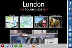
Rough Guides Map London... These guides are a series of fantastic interactive maps.
Produced in conjunction with the premier travel publisher Rough Guides.
Discover and explore London using full colour interactive linked maps, in this simple to use PDA version of The Rough Guides London.
Find all the top tourist spots and key attractions with ease, information on the city and its sights can be quickly displayed with links to photographs and map locations. All in a superb easy to use interface.
If you''re travelling to London, be sure you don''t leave home without this guide on your PDA.
The Rough Guide city maps includes:
Fully scrollable and interactive maps of the city.
Tap any location to display information and available links.
Intuitive navigation bar meaning you are never more than one click away from the information you require.
Map links allow you to directly link to other maps, photographs, or detailed views.
Categorised Find feature allowing you to quickly find any street, place of interest or station.
Categorised Information feature providing a wealth of information on the city, places of interest, etc.
1-Click Home feature, keeping the Home map always at hand.
Zoom function on all maps.
Special Offer Only $20.00
Hi Res & landscape displays supported.
Like it? Share with your friends!
If you got an error while installing Themes, Software or Games, please, read FAQ.
Supported operating systems:
Pocket PC 2002, Windows Mobile 2003, Windows Mobile 5.0, Windows Mobile 6 Classic, Windows Mobile 6 Professional, Windows Mobile 6.1 Classic, Windows Mobile 6.1 Professional, Windows Mobile 6.5 Professional
Tube London City Streets (2009 Edition) Tube London City Streets
This Tube package consists of a fully scrollable detailed map of the London Underground system and 9 linked GPS enabled A-Z street maps.
Plan journeys on the London Underground system, list details of the quickest routes and see a superb animated display of your journey tracking around the system map
TwitterGPSer TwitterGPSer uses the GPS on your PocketPC to find your current latitude/longitude/speed and allows you to update Twitter.com. Tap the button to get the GPS lock and when the program gets the lock it will create a Tweet with a Google.com map link. This service is provided by Twitter
CarsMapper CarsMapper - This program allows you to set your home address/city/country. Then enter a local address and tap the button to view a route from or to your home location via Microsoft Live.com Service.
This program requires that you have both the 'BeanDLL.dll' file ** and ** the runtime files for Visual Basic on your PocketPC computer
MapGoogler MapGoogler uses the GPS on your PocketPC to find your current latitude/longitude/speed and altitude and allows you to view your position on a map from the Google.com maps service. You can customize the maps zoom, and type via the 'Options' in the toolbar. The maps service is provided by Google
CartoType Demo (Windows Mobile) CartoType A simple map viewer using the CartoType library.
The program is installed in the folder My Device/Program Files/CartoType. Click on the CartoTypeDemo icon to run the program, then select Open Map.. from the menu to open a map. A map of Berlin is supplied as a sample.
Apart from the menu commands, you can zoom in by pressing the joystick or rolling ball
Map of Rotterdam / Netherlands for City Advisor Map of Rotterdam / Netherlands for City Advisor - A Rotterdam map of Netherlands for City Advisor.
Instructions:
1. Download the map (zip file)
2. Extract the files in /CityAdvisor/maps
3. Open CityAdvisor -> Maps icon -> Menu -> Refresh
4
Metro Metro helps you find your way in the public transport systems (subway, bus, trams, ...) in more than 400 cities around the world. FREE, FAST & ACCURATE. Simply enter you start and end stops, hit the "Go" button and the program finds the fastest route
Speereo Voice Translator: English-Turkish (WM Smart) Speereo Voice Translator (SVT) is an ideal companion for traveling on business or leisure and also is an excellent aid for business communication. Running on Windows Mobile and Symbian based mobile devices it contains of over 4000 phrases in each of 16+ languages and many other useful features
Tube Hamburg (Palm OS) Tube Hamburg (Palm OS) - An award winning and highly acclaimed Palm OS application that guides you around the metro (S-Bahn / U-Bahn) system of Hamburg. An essential addition to your Palm device for locals and tourists alike.
Tube's features include:
A detailed clear colour (or grey scale) map of the transport system fully scrollable.
Quick find station utility
Tube Brussels (Palm OS) Tube Brussels (Palm OS) - An award winning and highly acclaimed Palm OS application that guides you around the metro & tram system of Brussels. An essential addition to your Palm device for locals and tourists alike.
Tube's features include:
A detailed clear colour (or grey scale) map of the transport system fully scrollable.
Quick find station utility
Rough Guides Map Madrid Rough Guides Map Madrid... These guides are a series of fantastic interactive maps.
Produced in conjunction with the premier travel publisher Rough Guides.
Discover and explore Madrid using full colour interactive linked maps, in this simple to use PDA version of The Rough Guides Madrid
Tube 2 Munich (Palm OS) Tube 2 Munich (Palm OS) - This map package for Tube 2 consists of a fully scrollable detailed map of the Munich metro, rail & tram system.
Plan journeys on this system, list details of the quickest routes and see a superb animated display of your journey tracking around the system map.
Munich is the capital city of Bavaria, the southern most German federal state
Tube 2 Paris Pro (UIQ3) Tube 2 Paris Pro (UIQ3) - This map package for Tube 2 consists of a fully scrollable detailed map of the Paris metro & RER system and linked high quality street maps of central Paris.
Plan journeys on the metro & RER system, list details of the quickest routes and see a superb animated display of your journey tracking around the system map
Tube Vienna (UIQ) Tube Vienna (UIQ) - Our award winning and highly acclaimed application that guides you around the metro system of Vienna is now available for your Symbian UIQ phone.
An essential addition to your P800 / P900 / P910 if you travel in or around this city.
· A detailed clear colour map of the Vienna metro system fully scrollable.
· Quick find station utility
Tube 2 Boston Pro (UIQ3) Tube 2 Boston Pro (UIQ3) - This map package for Tube 2 consists of a fully scrollable detailed map of the Boston metro & commuter rail system and linked street maps of central Boston.
Plan journeys on the metro system, list details of the quickest routes and see a superb animated display of your journey tracking around the system map
Tyne & Wear Metro by Zuti for iPad Tyne & Wear Metro by Zuti for iPad - The new Tyne & Wear Metro map makes it easy to travel in and around the city using the Nexus Metro system. Unlike old fashioned schematic style maps this product contains a geographically accurate central area showing major streets, parks and places of interest etc, allowing the user to easily get their bearings
Tube Toronto Pro (Palm OS) Tube Toronto Pro (Palm OS) - This award winning and highly acclaimed Palm application that guides you around the subway system of Toronto now comes in a pro version with these extra features :
A superb full colour street level map of the central Toronto area with a find feature that enables you to quickly find any street, place of interest or station on the map
Tube 2 New York City (Palm OS) Tube 2 New York City (Palm OS) - This map package for Tube 2 consists of a fully scrollable detailed map of the New York City MTA subway system.
Plan journeys on this system, list details of the quickest routes and see a superb animated display of your journey tracking around the system map


 Hi Res & landscape displays supported.
")


")


")
")
")
")

")
")
")

")
")