GPS data pusher, the current geographic position can be send in a special SMS message
Navigation with turn by turn route guidance in 3D view, cost advantage - don''t need internet connection, don''t need a map
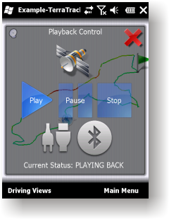
GPS simulator, playing back of recorded tracks
Route guidance in 3D view, makes navigation processes very simple and intuitive.
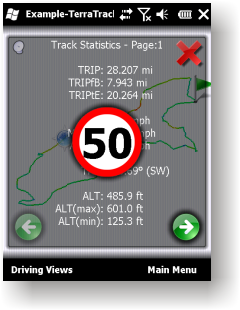
Recorded Track: Statistical analysis of track point information.
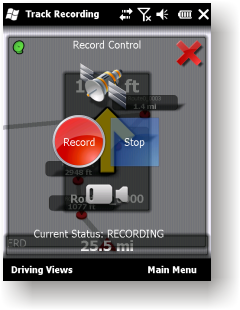
Track recording. Full NMEA-0183 format compatibility.
Playing back to your desktop PC''s NMEA-0183 Navigation software (Microsoft Streets and Trips 2010, Google Earth and many others). Virtual Serial Port (COM port) Driver for playing back at the same Windows phone.
Like it? Share with your friends!
If you got an error while installing Themes, Software or Games, please, read FAQ.
Supported operating systems:
Windows Mobile 2003, Windows Mobile 5.0, Windows Mobile 6 Classic, Windows Mobile 6 Professional, Windows Mobile 6.1 Classic, Windows Mobile 6.1 Professional, Windows Mobile 6.5 Professional
Similar Software:
hdSpeedo hdSpeedo is a speedometer that is driven from a GPS signal.
· User configurable background colours
· Day/Night colour schemes (Choose by clicking on the top status bar)
· Rotatable (Portrait or Landscape)
· Gesture enabled (Move between screens)
· Point and Track logging now available as
FilesGPSed FilesGPSed - FilesGPSed is a file explorer for files that are GPS-tagged. You can view the distance of each file from your current GPS location ascending distance order in real time. The program updates the distance of all files every 5 seconds based on your current GPS location.
This program requires that you have both the 'BeanDLL
amAze (LG) AmAze is a first of its kind free navigation and local search service. It is free to download and use and it contains wide coverage of maps including aerial photo in Europe, North America, Australia and parts of Asia and Africa
EmailGPSer EmailGPSer - EmailGPSer allows you to build email lists and update a person or all of the people on the list your current GPS. You can send the alert to just one email contact or all on the list. The email has a URL of your GPS from the Google.com maps service.
This program requires that you have both the 'BeanDLL
BoatOdometers BoatOdometers - BoatOdometers uses the GPS on your PocketPC to measure your boat's speed and displays it in real time in Knots/hr, KM/hr and Miles/hr. The program also displays your latitude and longitude.
This program requires that you have both the 'BeanDLL.dll' file ** and ** the runtime files for Visual Basic on your PocketPC computer
FON Access Points for Maldives FON Access Points for Maldives - FON offers you a new Points of Interest service (POIs). This allows you to download FONspots directly to your navigation device.
What does that mean? You can download a Points of Interest file directly to your navigation device
gOmniAgent GOmniAgent provides a real-time location tracking of mobile devices. It runs silently in the background with no user interface, and helps monitoring minors and your beloved ones from the gOmniTracker mobile applications or from gOmniTracker site
FileGPSeds FileGPSeds - FileGPSeds is a full-featured GPS tagged file viewer. You can browse the folders of the PocketPC for GPS tagged files and view the current distance from your GPS. You can also map the file GPS or all files in a folder on a map from Google.com maps service.
This program requires that you have both the 'BeanDLL
GPS Tuner Essentials Full Version with Central Europe Basic Map Content GPS Tuner Essentials Full Version with Central Europe Basic Map Content is designed specifically for off-road use: its large buttons, selectable tool window size, multiple Compass views and the built-in Tele Atlas map makes it extremely user-friendly and reliable
GPS Creations GPS Creations - Deploy practical GPS applications with GPS Pocket PC Creations. No need to be confined by limited menus with standard GPS software. Many applications in mining, agriculture, environment, transport, military, education and recreation
Comments on TerraTrack Recorder 7:
Comments not found
If you noted an error or download link is broken, please, report it via this page or use comments.
TerraTrack Recorder 7 is compatible with your device Intermec CS40 QWERTY / Numeric


")


