Marathon is a Windows Mobile application which keeps track of your movement with the help of a GPS-receiver. It is the perfect companion for sporting activates such as running, skiing or ice skating.
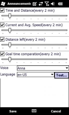
You can configure Marathon to announce various statistics in the headset or speaker while you’re recording. This gives you the advantage of always knowing your performance and is a great morale boost to reach your goals.
You can compete with yourself by setting the goal time comparation settings to one of your previous results. This will allow the announcements to tell you exactly how many seconds ahead or behind you are. You may also use the generic time goal in case you haven’t recorded anything to compete against.
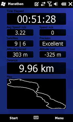
The application records and displays data such as time, distance, speed and your altitude change. You can also choose to display your speed and altitude as bar or line charts, as well as showing a map of your recording.
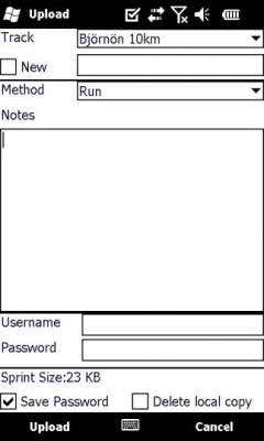
As a complement to the application you can upload your results to this website, which allows you to see more detailed information about your performance, as well as various rankings against other users of the service.
· Announce various statistics in the headset or speaker while running.
· Compete with yourself by using a previous recording or a generic time based goal.
· Records data such as time, distance, speed, altitude change.
· Can show a graph over your speed/altitude as well as a map of the track.
· Upload the result to marathon-mobile.net to see more detailed info and compare your results with others.
· This special trial version is valid until 2009-12-15, and will be extended until Windows Mobile Marketplace is available for 6.0 devices.
What's New in This Release:
· Optimized memory management when opening saved results.
· Minor changes to the Twitter OAuth implementation.
· Fixed a rarely occurring bug which caused the wrong altitude change to be reported when a 2D GPS fix turns into a 3D GPS
Like it? Share with your friends!
If you got an error while installing Themes, Software or Games, please, read FAQ.
Supported operating systems:
Windows Mobile 5.0, Windows Mobile 6 Classic, Windows Mobile 6 Professional, Windows Mobile 6.1 Classic, Windows Mobile 6.1 Professional, Windows Mobile 6.5 Professional
Similar Software:
FamilyUpdaterer FamilyUpdaterer - This program allows you to create a family text webpage where family members can view your current status with the PocketPC FamilyUpdateds. Enter your update to send it to the FTP server.
This program requires that you have both the 'BeanDLL.dll' file ** and ** the runtime files for Visual Basic on your PocketPC computer
MapDrawerer MapDrawerer allows you to download a Google.com map of your current GPS and edit it with a full-featured drawing tool. You can draw on the map and also insert text into the maps as well as use the drawing tools. The JPEG libraries are from Independent JPEG Group. The map service is provided by Google
FON Access Points for Belgium FON Access Points for Belgium - FON offers you a new Points of Interest service (POIs). This allows you to download FONspots directly to your navigation device.
What does that mean? You can download a Points of Interest file directly to your navigation device
TravelAddresserer TravelAddresserer uses the GPS on your PocketPC to find your current latitude/ longitude/ speed/ altitude and Googles the Country/ Street address and allows you to view your position on a map from the Google.com maps service. You can customize the maps zoom, and type via the 'Options' in the toolbar
gOmniAgent GOmniAgent provides a real-time location tracking of mobile devices. It runs silently in the background with no user interface, and helps monitoring minors and your beloved ones from the gOmniTracker mobile applications or from gOmniTracker site
GPS2day GPS2day is a today screen plug-in showing your current GPS coordinates, speed, satellite info, etc...
Languages: English, Czech, Dutch, French, German, Hungarian, Italian, Japanese, Polish, Russian, Spanish.
Currently GPS2day program works as GPS informer. It supports both metric and U.S
GPS Videorecorder GPS Videorecorder is an Animation and Analysis Software for GPS Data. The Software can be used in the same way as a Videorecorder with Play, Record, Rewind and FastForward. Furthermore you can add handwritten notes to the video and measure distances and areas. A Geocashfinder and an interactive help are also part of the program
SupertweetGPS SupertweetGPS - SupertweetGPS allows you to send GPS based tweets to Twitter via SuperTweet.net. When you get a GPS lock enter the text and tap the button to send the Tweet with your current GPS. The program will send the tweet to Twitter.com with your current GPS. NOTE: To use Geolocation on Twitter in 'Settings/Account/Tweet Location' enable
FileGPSeds FileGPSeds - FileGPSeds is a full-featured GPS tagged file viewer. You can browse the folders of the PocketPC for GPS tagged files and view the current distance from your GPS. You can also map the file GPS or all files in a folder on a map from Google.com maps service.
This program requires that you have both the 'BeanDLL
FON Access Points for Uruguai FON Access Points for Uruguai - FON offers you a new Points of Interest service (POIs). This allows you to download FONspots directly to your navigation device.
What does that mean? You can download a Points of Interest file directly to your navigation device
Other Software by developer «JMD Software»:
Marathon FREE Marathon FREE can record and save your movement, It's the perfect companion for sporting activities such as running and biking. Thanks to the announcement feature you'll get feedback without taking your phone out of the pocket. Compete against your previous results for motivation and help to reach your goals