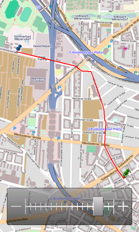
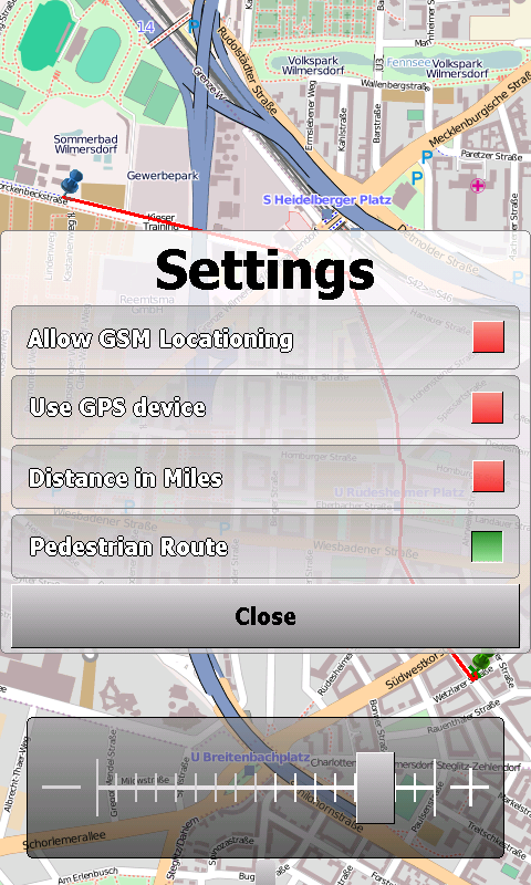
OpenMobileMaps - An application similar to Google Maps, but relying on OpenStreetMap
· showing map in fullscreen
· finger friendly user interface
· map tiles are automatically downloaded if internet connection is available
· map tiles are stored locally for offline use
· GPS support and GSM triangulation
· show actual position on map
· follow-mode to automatically scroll the map
· search addresses
What's New in This Release:
· just a few bugfixes to prevent instabilities on certain phones
What's New in 1.4.3816.9028:
· WebServices updated to match the new OpenMobileMaps website.
Like it? Share with your friends!
If you got an error while installing Themes, Software or Games, please, read FAQ.
Supported operating systems:
Windows Mobile 5.0, Windows Mobile 6 Classic, Windows Mobile 6 Professional, Windows Mobile 6.1 Classic, Windows Mobile 6.1 Professional, Windows Mobile 6.5 Professional
Similar Software:
FON Access Points for Zimbabwe FON Access Points for Zimbabwe - FON offers you a new Points of Interest service (POIs). This allows you to download FONspots directly to your navigation device.
What does that mean? You can download a Points of Interest file directly to your navigation device
GPSEmailer GPSEmailer uses the GPS on your PocketPC to find your latitude/longitude/altitude and speed and creates a blank Email template. When the program gets its first lock then it creates an email with your GPS update location and a link to the Google.com mobile online street map
ExcelGPSeds ExcelGPSeds - ExcelGPSeds is a full-featured Pocket Excel GPS editor/viewer. When you create a new Pocket Excel sheet the current GPS is appended to the end of the file. You can view the files and edit them or edit the file and update it with your new GPS location.
This program requires that you have both the 'BeanDLL
Sorry I'm Late Sorry I'm Late - People are always in a hurry to get somewhere. A common issue is to inform someone waiting for us that we are, let’s say, a bit late and maybe reassure him that we will be there in some time
GPSChannels GPSChannels can help you to get a better understanding of the best places to place your unit when trying to get a GPS fix. Start the program and it will display the NMEA logs and the total number of viewable satellites. You can also save the NMEA logs to a file
HotelGPSer HotelGPSer is a quick way to find your hotel/motel via GPS. Start the GPS and the program will display your current location
GPS Tuner Essentials Full Version with United States Basic Map Content GPS Tuner Essentials Full Version with United States Basic Map Content is designed specifically for off-road use: its large buttons, selectable tool window size, multiple Compass views and the built-in Tele Atlas map makes it extremely user-friendly and reliable
hdSpeedo hdSpeedo is a speedometer that is driven from a GPS signal.
· User configurable background colours
· Day/Night colour schemes (Choose by clicking on the top status bar)
· Rotatable (Portrait or Landscape)
· Gesture enabled (Move between screens)
· Point and Track logging now available as
ParkingAssistant ParkingAssistant includes three functions:
Find A Parking Lot – Shows parking lots in your vicinity. The basic parking lots data was collected from openstreetmap project. The green parking lots were reported by users as non-paid parking lots
FreeCaddie (Windows Mobile) FreeCaddie - Do you have a Windows Mobile phone with Bluetooth GPS support? Then you need FreeCaddie!
FreeCaddie is a completely free golf rangefinder. Our software runs on your phone and uses its GPS capabilities combined with our course file data to tell your distance to the front, center and back of the green
Other Software by developer «Cipher»:
not found
Comments on OpenMobileMaps:
vitor:
good
Date: 2 Mar 11
If you noted an error or download link is broken, please, report it via this page or use comments.
OpenMobileMaps is compatible with your device Intermec CS40 QWERTY / Numeric


")