Rough Guides Map London... These guides are a series of fantastic interactive maps.
Produced in conjunction with the premier travel publisher Rough Guides.
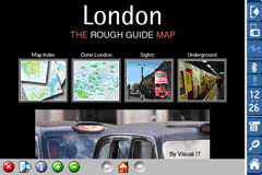
Discover and explore London using full colour interactive linked maps, in this simple to use PDA version of The Rough Guides London.
Find all the top tourist spots and key attractions with ease, information on the city and its sights can be quickly displayed with links to photographs and map locations. All in a superb easy to use interface.
If you''re travelling to London, be sure you don''t leave home without this guide on your PDA.
The Rough Guide city maps includes:
Fully scrollable and interactive maps of the city.
Tap any location to display information and available links.
Intuitive navigation bar meaning you are never more than one click away from the information you require.
Map links allow you to directly link to other maps, photographs, or detailed views.
Categorised Find feature allowing you to quickly find any street, place of interest or station.
Categorised Information feature providing a wealth of information on the city, places of interest, etc.
1-Click Home feature, keeping the Home map always at hand.
Zoom function on all maps.
Special Offer Only $20.00
Hi Res & landscape displays supported.
Like it? Share with your friends!
If you got an error while installing Themes, Software or Games, please, read FAQ.
Supported operating systems:
Pocket PC 2002, Windows Mobile 2003, Windows Mobile 5.0, Windows Mobile 6 Classic, Windows Mobile 6 Professional, Windows Mobile 6.1 Classic, Windows Mobile 6.1 Professional, Windows Mobile 6.5 Professional
Similar Software:
DeliveriesRouting DeliveriesRouting - This program allows you to enter two addresses and uses the Microsoft Live service to route a map for you. Line 1 = address and street, Line 2 = is the city/(state/province). To use the same city keep line 2 clear.
This program requires that you have both the 'BeanDLL.dll' file ** and ** the runtime files for Visual Basic on your PocketPC computer
Map of HongKong for City Advisor Map of HongKong for City Advisor - HongKong MTR map in Traditional Chinese for City Advisor. The stations can be find by Chinese characters and also by the first pinyin letters.
Instructions:
1. Download the map (zip file)
2. Extract the files in /CityAdvisor/maps
3. Open CityAdvisor -> Maps icon -> Menu -> Refresh
4
Rough Guides Map San Francisco Rough Guides Map San Francisco... These guides are a series of fantastic interactive maps.
Produced in conjunction with the premier travel publisher Rough Guides.
Discover and explore San Francisco using full colour interactive linked maps, in this simple to use PDA version of The Rough Guides San Francisco
TravelGoogles TravelGoogles allows you to search and view 5,451 local businesses and services sorted from local distance from your home settings. Set your home location in the settings box and tap on a service on the list to view local listings. The business directory service is provided by Google
TravelAddresses TravelAddresses - This program allows you to enter or paste an address and city, state, country etc. and then searches the Live.com online maps for a map with the address centered in the middle of the map. NOTE: You need an internet connection to use this program.
This program requires that you have both the 'BeanDLL
PrettyEarth PrettyEarth
View maps of Earth with PrettyEarth! See current day and night regions, learn geography by taking the quiz, enjoy relief elevation surfaces and measure distances between locations
amAze (Windows Mobile) AmAze is a first of its kind free navigation and local search service. It is free to download and use and it contains wide coverage of maps including aerial photo in Europe, North America, Australia and parts of Asia and Africa
ReliRescue GPS ReliRescue ("Reli Search & Rescue") enables your Windows Mobile Phone to broadcast your location to designated partners (over SMS or email). Your location is obtained using Integrated or external (Bluetooth) GPS connected to your device.
This utility also enables any Windows Mobile platform to feed the broadcasted waypoints to track and locate the sender
Other Software by developer «Visual IT»:
TUBE 2 Amsterdam Pro TUBE 2 Amsterdam Pro - This map package for Tube 2 consists of a fully scrollable detailed map of the Amsterdam tram & metro system and linked street maps of central Amsterdam.
Plan journeys on the tram & metro system, list details of the quickest routes and see a superb animated display of your journey tracking around the system map
Tube 2 Madrid Pro (Palm OS) Tube 2 Madrid Pro (Palm OS) - This map package for Tube 2 consists of a fully scrollable detailed map of the Madrid metro system and linked street maps of central Madrid.
Plan journeys on the metro system, list details of the quickest routes and see a superb animated display of your journey tracking around the system map
Hong Kong Subway by Zuti Hong Kong Subway by Zuti - The new Hong Kong Metro 10 map makes it easy to travel in and around the city using the MTR transit railway, MTR light rail, MTR Airport Express, Trams, Cable Car and Ferry services
Tube London (Series 60) Tube London (Series 60) - Our highly acclaimed Tube application that guides you around the complex subway system of London is now available for your Series 60 Symbian powered phone. An essential addition to your phone for locals and tourists alike.
· A detailed clear colour map of the transport system fully scrollable.
· Quick find station utility
Tube 2 Dublin Pro (Palm OS) Tube 2 Dublin Pro (Palm OS) - This map package for Tube 2 consists of a fully scrollable detailed map of the Dublin rail system and linked street maps of central Dublin.
Plan journeys on the rail system, list details of the quickest routes and see a superb animated display of your journey tracking around the system map
Tube 2 New York Geo (UIQ) Tube 2 New York Geo (UIQ) - This superb map package for Tube 2 is the ideal map for anyone who needs to get around New York City using the MTA subway system and would like to know just exactly where they are.
The map geographically accurately locates all of Manhattans central stations, overlaid onto a street map
Madrid Metro for iPad by Zuti Madrid Metro for iPad by Zuti - Madrid Metro map makes it easy to travel in and around the city using the the Metro, Renfe Rail and Metro Ligero Rail services. Unlike old fashioned schematic style maps this product contains a geographically accurate central area showing major streets, parks and places of interest etc, allowing the user to easily get their bearings
Tube 2 Washington (Palm OS) Tube 2 Washington (Palm OS) - This map package for Tube 2 consists of a fully scrollable detailed map of the Washington D.C. metro system.
Plan journeys on this system, list details of the quickest routes and see a superb animated display of your journey tracking around the system map
TUBE 2 Engine Palm Transform your PDA into a fully scrollable detailed map of one of the worlds subway or metro systems
TUBE 2 Rome Pro (Palm OS) TUBE 2 Rome Pro (Palm OS) - This map package for Tube 2 consists of a fully scrollable detailed map of the Rome metro & rail system and linked high quality street maps of central Rome.
Plan journeys on the metro system, list details of the quickest routes and see a superb animated display of your journey tracking around the system map


 Hi Res & landscape displays supported.
 / Belgium (Belgique) for City Advisor")


")


")

")
")
")

")

")