GPS data pusher, the current geographic position can be send in a special SMS message
Navigation with turn by turn route guidance in 3D view, cost advantage - don''t need internet connection, don''t need a map
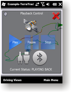
GPS simulator, playing back of recorded tracks
Route guidance in 3D view, makes navigation processes very simple and intuitive.
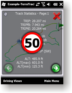
Recorded Track: Statistical analysis of track point information.
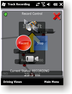
Track recording. Full NMEA-0183 format compatibility.
Playing back to your desktop PC''s NMEA-0183 Navigation software (Microsoft Streets and Trips 2010, Google Earth and many others). Virtual Serial Port (COM port) Driver for playing back at the same Windows phone.
Like it? Share with your friends!
If you got an error while installing Themes, Software or Games, please, read FAQ.
Supported operating systems:
Windows Mobile 2003, Windows Mobile 5.0, Windows Mobile 6 Classic, Windows Mobile 6 Professional, Windows Mobile 6.1 Classic, Windows Mobile 6.1 Professional, Windows Mobile 6.5 Professional
Similar Software:
FON Access Points for Cyprus FON Access Points for Cyprus - FON offers you a new Points of Interest service (POIs). This allows you to download FONspots directly to your navigation device.
What does that mean? You can download a Points of Interest file directly to your navigation device
FON Access Points for Costa Rica FON Access Points for Costa Rica - FON offers you a new Points of Interest service (POIs). This allows you to download FONspots directly to your navigation device.
What does that mean? You can download a Points of Interest file directly to your navigation device
Mobitee Lite Mobitee is a mobile application intended for both skilled and beginning golfers with the purpose to diversify the game and make it accessible simultaneously allowing to raise game level
BikeTrack BikeTrack - This application enables everybody (who got your user/pass) look up your location on the net, using your the page http://fiets.galway.nl/ and keeps track of you.
On the webpage you can also create a username so you can use the software.
What it does:
- Gets location from GPS.
- Sends it to BikeTrack Server
Navigation BE-ON-ROAD Europe Q2/2011 Navigation BE-ON-ROAD Europe Q2/2011 - The new major version of be-on-road presents new features and is based on new platform which brings high level of reliability, portability and speed on almost any kind of device. The new be-on-road brings high value voice guided door-to-door navigation
VoiceGPSer VoiceGPSer - VoiceGPSer allows you to record your voice into wave files and attaches the GPS location to the end of the wave file. You can then view the voice recordings via distance in the viewer. This program uses "The Vincenty inverse formula for ellipsoids." (accuracy to within 0.5mm, or 0.000015")
This program requires that you have both the 'BeanDLL
PictureGPSer PictureGPSer - PictureGPSer checks the camera storage folder for new pictures/videos and when detected places the current GPS tag at the end of the image/video. You can also view the images via a distance file viewer. You can also view and download a map of the pictures from Google.com.
This program requires that you have both the 'BeanDLL
FON Access Points for Guernsey FON Access Points for Guernsey - FON offers you a new Points of Interest service (POIs). This allows you to download FONspots directly to your navigation device.
What does that mean? You can download a Points of Interest file directly to your navigation device
FON Access Points for Monaco FON Access Points for Monaco - FON offers you a new Points of Interest service (POIs). This allows you to download FONspots directly to your navigation device.
What does that mean? You can download a Points of Interest file directly to your navigation device
PoliceGPSer PoliceGPSer - PoliceGPSer converts the PocketPC into a GPS locator and reporter device. Select the update interval and the program will send the GPS location of the device to a FTP server at the interval. You can view the GPS of all GPS devices with the PocketPC PoliceGPSes.
This program requires that you have both the 'BeanDLL
Comments on TerraTrack Recorder 7:
Comments not found
If you noted an error or download link is broken, please, report it via this page or use comments.
TerraTrack Recorder 7 is compatible with your device Intermec CS40 QWERTY / Numeric