Platforms: iPhone, iPad, iPod Touch, Apple iPhone OS
Categories: Travel & Navigation
Upload date: 26 Nov 11
Developer: ALK Technologies
License: Commercial
Price: 149.99 $
Downloads: 100
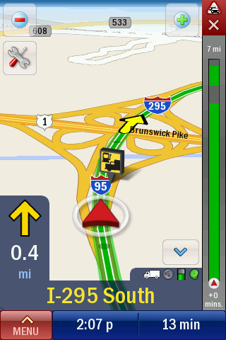
CoPilot Truck North America - Introducing CoPilot Truck — the first voice-guided GPS Navigation iPhone app designed specifically for professional drivers of trucks and other large vehicles.
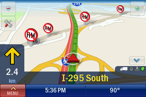
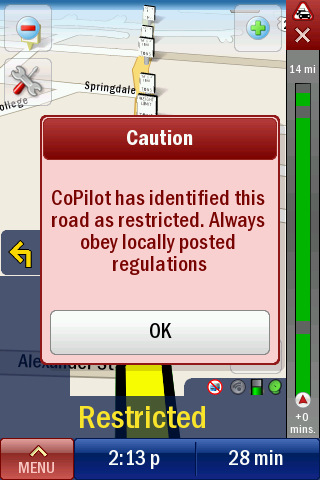
Unlike consumer navigation applications, CoPilot Truck takes into account truck-restricted and prohibited roads to provide drivers safe and reliable navigation on truck-legal roads. It automatically calculates routes based on your vehicle size, weight, width and load type to avoid commercial truck restrictions.
· Avoids low bridge clearances and weight/height/width-restricted roads
· Choice of routing options including Practical, Shortest, and 53’/102” Trailer or Twins, National Network and Toll Avoidance
· Avoids truck-prohibited turns and U-turns
· Avoids Hazmat or flammable materials-restricted roads
Based on the award-winning CoPilot Live navigation app and incorporating industry standard PC*MILER truck-specific attributes, CoPilot Truck automatically favors major roads, significantly reducing the likelihood of being guided along narrow lanes and through residential areas. It can help increase efficiency, reduce mileage and help avoid costly fines and vehicle damage.
Detailed street-level maps of the U.S. and Canada are stored on your phone, so there are no monthly fees – and no map downloads. TRUCK-SPECIFIC NAVIGATION FEATURES:
· Automatically calculates truck-appropriate routes avoiding restricted roads and hazards
· Adjustable route settings for specific vehicle sizes and load types
· Create custom profiles for easy switching between vehicles
· Millions of useful Points of Interest including truck specific categories: truck services, truck stops, rest areas, weigh stations and Cat Scales
· Generate state mileage logs to provide an accurate record for billing and tax calculation PREMIUM GPS NAVIGATION ON YOUR iPHONE:
· Turn-by-turn voice directions with text-to-speech technology to pronounce full street names (Turn right on Main Street)
· Clear 3D and 2D driving views with speed-variable zoom
· Fast automatic rerouting if you miss a turn
· Real sign post information and lane indicator arrows for clear guidance at exits and complex intersections
· CoPilot ClearTurn realistic view on the approach to exits and complex intersections
· Navigate to a house number, street or address book contact
· Multiple-stop trips, waypoints and pre-trip planning MAPS INCLUDED:
· ALK Digital Maps of the U.S. and Canada enhanced with PC*MILER truck-specific attributes
· 3.52 million commercial truck restrictions and allowances iPHONE INTEGRATION:
· Continuous turn-by-turn navigation during phone calls and while using other apps
· Access iPod music controls from in-app
· Dial or navigate to Points of Interest by tapping on-screen
· Portrait or landscape display with pinch to zoom the map LIVE SERVICES:
· Live Local Internet Search to find nearby businesses and brands
· Live weather info for your location/destination
· Optional ActiveTraffic service (available for purchase after 30 days use expires) provides real-time visibility of traffic conditions on your route and the impact traffic will have on your ETA. ActiveTraffic automatically calculates the fastest route to avoid congestion and alerts you if a faster route is available as you drive.
What's New in This Release:
· Updated map data
What's New in 8.2.0.743:
· Updated with 2011 Q2 map data
What's New in 8.2.0.634:
· This update provides improvements to the ActiveTraffic service.
Like it? Share with your friends!
If you got an error while installing Themes, Software or Games, please, read FAQ.
Supported operating systems:
Apple iOS 10.x (iPad), Apple iOS 10.x (iPhone), Apple iOS 11.x (iPad), Apple iOS 12.x (iPad), Apple iOS 12.x (iPhone), Apple iOS 4.0.x (iPhone), Apple iOS 4.0.x (iPod Touch), Apple iOS 4.2.x (iPad), Apple iOS 4.2.x (iPhone), Apple iOS 4.2.x (iPod Touch), Apple iOS 4.3.x (iPad), Apple iOS 4.3.x (iPhone), Apple iOS 4.3.x (iPod Touch), Apple iOS 5.0 (iPad), Apple iOS 5.0 (iPhone), Apple iOS 5.0 (iPod Touch), Apple iOS 6.0 (iPad), Apple iOS 6.0 (iPhone), Apple iOS 6.0 (iPod Touch), Apple iOS 7.0 (iPad), Apple iOS 7.0 (iPhone), Apple iOS 7.0 (iPod Touch), Apple iOS 8.x (iPad), Apple iOS 8.x (iPhone), Apple iOS 8.x (iPod Touch), Apple iOS 9.x (iPad), Apple iOS 9.x (iPhone), Apple iOS 9.x (iPod Touch), Apple iPhone OS 3.1.x, Apple iPhone OS 3.1.x (iPod Touch), Apple iPhone OS 3.2.x (iPad)
Similar Software:
Marine: Hebrides - GPS Map Navigator Marine: Hebrides - GPS Map Navigator - FlytoMap provides complete, quick and easy to use map applications for navigation for iPhone. Continues in the tradition of offering depth of information and functionality across expected places all over the world, exploring the map you get maximum details obtaining detailed information of every object on the map
Harz National Park - GPS Map Navigator Harz National Park - flytoMap provides complete, quick and easy to use map applications for navigation for iPhone. Continues in the tradition of offering depth of information and functionality across expected places all over the world, exploring the map you get maximum details obtaining detailed information of every object on the map
Worcester (MA, USA) Map Offline Worcester (MA, USA) Map Offline - This will be perfect when you are traveling and you don't have internet connection. This Offline Maps is not a replacement of Google Maps. It is used when you don't have internet connection and want to use maps
Magellan RoadMate North America Transform your iPhone or iPod touch into an easy-to-use GPS navigator with real-time traffic alerts included!
Erie (PA, USA) Map Offline Erie (PA, USA) Map Offline - This will be perfect when you are traveling and you don't have internet connection. This Offline Maps is not a replacement of Google Maps. It is used when you don't have internet connection and want to use maps
Marine: Chesapeake Bay - GPS Map Navigator Marine: Chesapeake Bay - GPS Map Navigator - Continues in the tradition of offering depth of information and functionality across expected places all over the world, exploring the map you get maximum details obtaining detailed information of each object on the map
Paris GPS Guide The only thing we do, help you to move freely as an alien, by "Offline" & "GPS"
NAVIGON France NAVIGON France - With the NAVIGON MobileNavigator you can transform your iPhone into a fully functional mobile navigation system that is every bit as good as the multi-award-winning personal navigation devices from NAVIGON in terms of its user-friendliness and features
Eindhoven (Netherland) Maps Offline Eindhoven (Netherland) Maps Offline - This will be perfect when you are traveling and you don't have internet connection. This Offline Maps is not a replacement of Google Maps. It is used when you don't have internet connection and want to use maps
CoPilot Live Premium BeNeLux CoPilot Live Premium BeNeLux - CoPilot Live Premium is the essential voice-guided sat nav application to get you where you need to go, by the way that suits you best
Other Software by developer «ALK Technologies»:
CoPilot Live Premium Iberia CoPilot Live Premium Iberia - CoPilot Live Premium is the essential voice-guided sat navigation app to get you where you need to go, by the way that suits you best
CoPilot Live North America CoPilot Live North America - CoPilot Live is one of the most highly acclaimed mobile GPS navigation applications available, widely recognized by the experts as the best blend of features and performance for an amazing price.
With complete, detailed street maps of the U.S
CoPilot Live HD Europe CoPilot Live HD Europe - With its sensational hi-resolution graphics, CoPilot Live HD gives you the ultimate in-car guidance experience.
Price includes maps of ONE European region. Choose your region the first time you run the application. You can also buy complete maps of Europe through in-app purchase
CoPilot Premium Italy for iOS CoPilot Premium Italy for iOS - CoPilot is a powerful GPS navigation solution for iPhone, iPad and iPod touch. The app comes with downloadable maps of Italy, which can be used offline, allowing you to find your way even when you don't have an internet connection
CoPilot Premium Europe (Android) CoPilot Premium Europe (Android) - CoPilot Premium is a powerful GPS navigation solution for Android smartphones and tablets. The app comes with downloadable maps of more than 40 European countries, which can be used offline, allowing you to find your way even when you don't have an internet connection
CoPilot Live France CoPilot Live France - Welcome to CoPilot Live, the award winning turn-by-turn iPhone sat navigation app with complete street maps of France and door to door voice directions.
CoPilot Live is packed full of advanced navigation features to guide you easily and accurately, including clear 3D map displays, lane indicator arrows and speed limit alerts
CoPilot Live BeNeLux CoPilot Live BeNeLux - Welcome to CoPilot Live, the award-winning sat navigation app that runs on your iPhone to guide you door to door with complete street maps of Belgium, Netherlands and Luxembourg.
CoPilot Live is the personal travelling assistant who's always at your side, ready to guide you to the door with turn-by-turn voice directions
CoPilot Premium France for iOS CoPilot Premium France for iOS - CoPilot is a powerful GPS navigation solution for iPhone, iPad and iPod touch. The app comes with downloadable maps of France, which can be used offline, allowing you to find your way even when you don't have an internet connection
CoPilot Live Premium GPS - USA & Canada CoPilot Live Premium GPS - USA & Canada - Now there’s a better way to navigate.
CoPilot Live Premium is a brand new voice-guided GPS navigation app
CoPilot Premium France for iOS CoPilot Premium France for iOS - CoPilot is a powerful GPS navigation solution for iPhone, iPad and iPod touch. The app comes with downloadable maps of France, which can be used offline, allowing you to find your way even when you don't have an internet connection


 Map Offline")

 Map Offline")


 Maps Offline")


")


