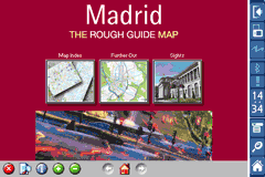
Rough Guides Map Madrid... These guides are a series of fantastic interactive maps.
Produced in conjunction with the premier travel publisher Rough Guides.
Discover and explore Madrid using full colour interactive linked maps, in this simple to use PDA version of The Rough Guides Madrid.
Find all the top tourist spots and key attractions with ease, information on the city and its sights can be quickly displayed with links to photographs and map locations. All in a superb easy to use interface.
If you''re travelling to Madrid, be sure you don''t leave home without this guide on your PDA.
The Rough Guide city maps includes:
Fully scrollable and interactive maps of the city.
Tap any location to display information and available links.
Intuitive navigation bar meaning you are never more than one click away from the information you require.
Map links allow you to directly link to other maps, photographs, or detailed views.
Categorised Find feature allowing you to quickly find any street, place of interest or station.
Categorised Information feature providing a wealth of information on the city, places of interest, etc.
1-Click Home feature, keeping the Home map always at hand.
Zoom function on all maps.
Hi Res & landscape displays supported.
Like it? Share with your friends!
If you got an error while installing Themes, Software or Games, please, read FAQ.
Supported operating systems:
Pocket PC 2002, Windows Mobile 2003, Windows Mobile 5.0, Windows Mobile 6 Classic, Windows Mobile 6 Professional, Windows Mobile 6.1 Classic, Windows Mobile 6.1 Professional, Windows Mobile 6.5 Professional
Similar Software:
Leeds Pocket A-Z map Leeds Pocket A-Z map - This publication has been designed for a Pocket PC running Windows® Mobile-based Pocket PC (version 2002 or later) and the Pocket A-Z Viewer (included)
MetroMap Metro map (Moscow, St. Petersburg, Minsk, Kiev, Ekaterinburg, Nizhny Novgorod, Novosibirsk, Samara
Rough Guides Map Paris Rough Guides Map Paris... These guides are a series of fantastic interactive maps.
Produced in conjunction with the premier travel publisher Rough Guides.
Discover and explore Paris using full colour interactive linked maps, in this simple to use PDA version of The Rough Guides Paris
LittleWays LittleWays - LittleWays is a simple route calculator for subways, tramways, bus lines and rapid train railways.
Using LittleWays you can provide start and end station and LittleWays will calculate all possible ways and displays them in a list. It's your choice which way you use. After selecting a route it will be displayed as a bold red line
Map of Utah (US State) Map of Utah (US State) - A map of the Utah by VITO Technology. Good for intercity travels with SmartMap.
SmartMap is a mobile device application which uses vector and raster maps. It is compatible with any NMEA protocol GPS receiver (Compact Flash socket, serial port, BlueTooth or sleeve)
TwitterGPSes TwitterGPSes allows you to view the current GPS and status of your Twitter contacts. Enter the name of each contact to assign to a button. When you tap on the button the persons Twitter page will be downloaded and a Google.com map will display the location. This service is provided by Twitter
Map of New Mexico (US State) Map of New Mexico (US State) - A map of the New Mexico by VITO Technology. Good for intercity travels with SmartMap.
SmartMap is a mobile device application which uses vector and raster maps. It is compatible with any NMEA protocol GPS receiver (Compact Flash socket, serial port, BlueTooth or sleeve)
Earth&Sun for Pocket PC Earth&Sun for Pocket PC - The Earth&Sun an application for Ewe enabled computers. It shows the Sun Illuminated area of the Earth
Some will consider Earth&Sun to fall into the category of "fun and games".
We hope you find Earth&Sun useful and enjoy it.
· The latitude and longitude of an Earth location
Other Software by developer «Visual IT»:
Tube 2 Miami (Palm OS) Tube 2 Miami (Palm OS) - This map package for Tube 2 consists of a fully scrollable detailed map of the Miami metro & rail system.
Plan journeys on this system, list details of the quickest routes and see a superb animated display of your journey tracking around the system map
Hong Kong Subway for iPad by Zuti Hong Kong Subway for iPad by Zuti - Hong Kong Metro map makes it easy to travel in and around the city using the MTR transit railway, MTR light rail, MTR Airport Express, Trams, Cable Car and Ferry services
Tube 2 New York City (UIQ3) Tube 2 New York City (UIQ3) - This map package for Tube 2 consists of a fully scrollable detailed map of the New York City MTA subway system.
Plan journeys on this system, list details of the quickest routes and see a superb animated display of your journey tracking around the system map
Tube 2 New York Geo (UIQ3) Tube 2 New York Geo (UIQ3) - This superb map package for Tube 2 is the ideal map for anyone who needs to get around New York City using the MTA subway system and would like to know just exactly where they are.
The map geographically accurately locates all of Manhattans central stations, overlaid onto a street map
Tube Singapore (Series 60) Tube Singapore (Series 60) - Our highly acclaimed Tube application that guides you around the metro system of Singapore is now available for your Series 60 Symbian powered phone. An essential addition to your phone for locals and tourists alike.
· A detailed clear colour map of the Singapore metro system fully scrollable.
· Quick find station utility
Tube 2 Chicago (UIQ) Tube 2 Chicago (UIQ) - This map package for Tube 2 consists of a fully scrollable detailed map of the Chicago metro & commuter rail system.
It includes the rapid transport system of subway and elevated lines, in addition to the many commuter rail lines. The map also indicates how the Amtrak intercity routes intersect with the cities transport network
London Visitors A-Z for iPad London Visitors A-Z for iPad - The London Visitors A-Z map of central London is designed especially for the tourist
Boston Subway for iPad by Zuti Boston Subway for iPad by Zuti - This Boston Subway map makes it easy to travel in and around the city using the MBTA Subway, MBTA Commuter Rail, MBTA Boats, and Massport shuttle buses. Unlike old fashioned schematic style maps this product contains a geographically accurate central area showing major streets, parks and places of interest etc
Tube Vienna (iPhone) Tube Vienna (iPhone) is a superb interactive guide to the Vienna Metro (U-Bahn) and Vienna Tram (StrassenBahn) systems.
With no need for an internet connection Tube Vienna will always be available to display a clear and detailed view of the city transport systems, plus list and animate the optimum route for all your journeys
Washington Metro for iPad by Zuti Washington Metro for iPad by Zuti - The new Washington Metro 10 map makes it easy to travel in and around the city using the WMATA Metro, MARC and VME systems. Also included are the Potomac river taxi routes and the DC Circulator bus routes


 Hi Res & landscape displays supported.
![USA-UT [Utah] Map for EagleEye PDA Tracking System](https://static.mobyware.org/data/images/def_program_reduced.png "USA-UT [Utah] Map for EagleEye PDA Tracking System")


")

")

")

")
")
")
")


")
