Platforms: iPhone, iPad, iPod Touch, Apple iPhone OS
Categories: Travel & Navigation
Upload date: 15 Oct 11
Developer: Visual IT
License: Commercial
Price: 2.99 $
Downloads: 26
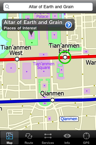
Beijing Subway by Zuti - The new Beijing Metro 10 map makes it easy to travel in and around the city using the Metro, Batong line, Airport Express line and Suburban S2 lines services. Unlike old fashioned schematic style maps this product contains a geographically accurate central area showing major streets, parks and places of interest etc, allowing the user to easily get their bearings.
MAP
The map is hand drawn by Visual IT and provides a unique geographically based view of Beijing with many places of interest drawn directly on the background so you can easily get your bearings when traveling around the city. You can also use your inbuilt GPS to accurately locate and track yourself within the city centre and see the nearest transportation stop and distance to it. This is the only pubic transportation route planner with this ability.
Tap on the map for location information, use the inbuilt search feature or choose from a list of locations. Places of interest, museums, hotels, parks, restaurant, shops, hospitals, streets, etc, are also included. The route planner will automatically suggest the nearest station to any place of interest you select.
MINUTE MAP
Another great feature is the “Minute Map” option which allows you to see the travel times from a start point to all other locations on the map. This is a unique way to view the topology of a city and gauge traveling times.
ROUTING
The application does not require an internet connection and will always be available to display a clear and detailed view of the city transport systems, plus list and animate the optimum route for your journey. This product provides the fastest route calculations of any mobile routing application (virtually instantaneous) using actual published journey times with the ability to select the quickest route or the route with the least changes.
· Full offline map and routing, no internet connection required.
· Colourful clear custom drawn geographically accurate mapping.
· Unique "Minute Map" feature allows quick view of all journey times from a start location.
· Services can be viewed on the map and turned on/off, routing around problems.
· Works on iPhone or iPod and in landscape or portrait mode.
· GPS location and tracking.
· Streets, Places of interest etc built into the application.
· Favourite routes can be stored and recalled.
· Access to live service information.
What's New in This Release:
· Support for retina display
· New "Measure Tool"
· Bug fix for iOS 5
What's New in 1.1:
· Updated map and routes.
· Faster map loading.
· New route description text and layout.
· New "Take me home" option.
· New "Recent routes" option.
· Various other minor updates and improvements.
Like it? Share with your friends!
If you got an error while installing Themes, Software or Games, please, read FAQ.
Supported operating systems:
Apple iOS 10.x (iPad), Apple iOS 10.x (iPhone), Apple iOS 11.x (iPad), Apple iOS 12.x (iPad), Apple iOS 12.x (iPhone), Apple iOS 4.0.x (iPhone), Apple iOS 4.0.x (iPod Touch), Apple iOS 4.2.x (iPad), Apple iOS 4.2.x (iPhone), Apple iOS 4.2.x (iPod Touch), Apple iOS 4.3.x (iPad), Apple iOS 4.3.x (iPhone), Apple iOS 4.3.x (iPod Touch), Apple iOS 5.0 (iPad), Apple iOS 5.0 (iPhone), Apple iOS 5.0 (iPod Touch), Apple iOS 6.0 (iPad), Apple iOS 6.0 (iPhone), Apple iOS 6.0 (iPod Touch), Apple iOS 7.0 (iPad), Apple iOS 7.0 (iPhone), Apple iOS 7.0 (iPod Touch), Apple iOS 8.x (iPad), Apple iOS 8.x (iPhone), Apple iOS 8.x (iPod Touch), Apple iOS 9.x (iPad), Apple iOS 9.x (iPhone), Apple iOS 9.x (iPod Touch), Apple iPhone OS 3.1.x, Apple iPhone OS 3.1.x (iPod Touch), Apple iPhone OS 3.2.x (iPad)
Similar Software:
Vermont Winter Fun Vermont Winter Fun - When the temperature takes a dive, crack into this application for a feast of activities, from mild to wild, to keep you entertained and out savoring the natural beauty of the Green Mountain State, in ways you might not have thought of until now
London Central Bus 10 London Central Bus 10 - The new Zuti London Bus map has finally arrived, making it easy to travel by bus anywhere in central London. This clear and colourful map covers a detailed street level area of 6 miles by 4 miles and includes over 1300 bus stops and 189 bus routes
London Metro Weekend Escapes London Metro Weekend Escapes - GPSmyCity.com's day trips and weekend getaways app is a powerful tool for planning a weekend away from the city. With a well researched list of getaway spots around the city you live in, you can explore natural wonders, regional history, and small town charm within a short drive from your home
TransitM&S San Antonio VIA TransitM&S San Antonio VIA - TransitM&S is an easy-to-use transit application that provides bus info for San Antonio's VIA Metropolitan Transit.
The app is designed for offline use. It is ideal for iPod Touch users. Even for iPhone users, it is designed to save money because AT&T no longer offers the unlimited data plan
London Tube by Zuti London Tube by Zuti - "London Tube 10" is a superb geographically based map and route planner for the London Underground, Overground, Docklands Light Railway (DLR), Croydon Tramlink and London Airport Express services. This is one in a worldwide series of Zuti maps from Visual IT who have been producing public transportation maps for mobile devices for many years
Vancouver Family Fun Vancouver Family Fun - Looking for the perfect family outing in Vancouver? Need a Vancouver restaurant that will feed both you and your kids? Not sure what to do with the family for the day? Then look no further. The Vancouver Family Fun application is filled with exciting attractions, child friendly restaurants and museums that will engage kids of all ages
thetrainline thetrainline is the UK's leading independent train ticket retailer. We sell tickets for all train companies to all national destinations.
This is the official application from thetrainline and is perfect for anyone who wants to view UK train times or buy tickets on the move
MetrO (iPhone) MetrO (iPhone) - MetrO helps you find your way in the public transportation in more than 400 cities around the world.
One application for all your trips: download the cities you need and search your route by subway, bus, railway, tram ... (depending on cities). NO network connection is required after you have installed the cities
Boston Subway by Zuti Boston Subway by Zuti - The new Boston Subway map makes it easy to travel in and around the city using the MBTA Subway, MBTA Commuter Rail, MBTA Boats, and Massport shuttle buses
Other Software by developer «Visual IT»:
Barcelona Metro by Zuti Barcelona Metro by Zuti - The Barcelona Metro application is a superb geographically based map and route planner for the Barcelona TMB (Transports Metropolitan de Barcelona) Metro and Tram services. This application is one in a worldwide series of Zuti maps from Visual IT who have been producing public transportation maps for mobile devices for many years
Tube 2 Amsterdam (Palm OS) Tube 2 Amsterdam (Palm OS) - This map package for Tube 2 consists of a fully scrollable detailed map of the Amsterdam tram & metro system.
Plan journeys on this system, list details of the quickest routes and see a superb animated display of your journey tracking around the system map
Tube 2 New York Geo (UIQ3) Tube 2 New York Geo (UIQ3) - This superb map package for Tube 2 is the ideal map for anyone who needs to get around New York City using the MTA subway system and would like to know just exactly where they are.
The map geographically accurately locates all of Manhattans central stations, overlaid onto a street map
Tube Milan (Series 60) Tube Milan (Series 60) - Our highly acclaimed Tube application that guides you around the metro system of Milan is now available for your Series 60 Symbian powered phone. An essential addition to your phone for locals and tourists alike.
· A detailed clear colour map of the Milan metro system fully scrollable.
· Quick find station utility
Tube Paris Pro (2009 Edition) Tube Paris Pro
New release with GPS support.
Tube plans all your journeys for you on the Paris metro & RER systems. It gives you the quickest routes, detailed on what trains to take and in what direction plus, service running times, fare zones, ticketing information and lots more...
Tube 2 New York City Pro (UIQ3) Tube 2 New York City Pro (UIQ3) - This map package for Tube 2 consists of a fully scrollable detailed map of the New York City MTA subway system and linked high quality street maps of Manhattan. Also included are additional reference maps of the rail systems surrounding NYC
Tube 2 Barcelona Pro (UIQ3) Tube 2 Barcelona Pro (UIQ3) - This map package for Tube 2 consists of a fully scrollable detailed map of the Barcelona metro & rail system and linked street maps of central Barcelona.
Plan journeys on the metro system, list details of the quickest routes and see a superb animated display of your journey tracking around the system map
Tube 2 Los Angeles (Palm OS) Tube 2 Los Angeles (Palm OS) - This map package for Tube 2 consists of a fully scrollable detailed map of the Los Angeles rail system.
Plan journeys on this system, list details of the quickest routes and see a superb animated display of your journey tracking around the system map
Tube 2 Munich (UIQ) Tube 2 Munich (UIQ) - This map package for Tube 2 consists of a fully scrollable detailed map of the Munich metro, rail & tram system.
Plan journeys on this system, list details of the quickest routes and see a superb animated display of your journey tracking around the system map.
Munich is the capital city of Bavaria, the southern most German federal state
London Mini A-Z London Mini A-Z - This map is a digital rendition of the famous "London A-Z Mini Atlas" and covers an area from West Hendon in the North West to Grove Park in the South East. Add this application to your iPhone or iPod Touch and you will have instant access to all 352 pages of the London Mini A-Z printed map


")


")
")
")
")
")
")
")
")
