Platforms: iPhone, iPad, iPod Touch, Apple iPhone OS
Categories: Science & Education
Upload date: 26 Nov 10
Developer: VITO Technology
License: Shareware
Price: 2.99 $
Downloads: 300
Star Walk Indispensable for amateurs and professionals, as well as for kids who are eager to learn, Star Walk will guide you through the night sky in style.
Star Walk is your personal planetarium that can answer all of your curiosities about the sky! For anyone who is interested in stargazing, amateurs or professionals Star Walk makes discovering more than 9,000 stars, planets, constellations, and messier objects as beautiful and easy as it has never been before!
Use the Star Spotter function to see the sky in front of you in real-time. Tilt your iPhone towards the sky to activate the DIGITAL COMPASS which will determine location and orientation of your phone. The image on your screen will correspond to the area of the sky you are pointing your phone towards, and it will follow your movements. Please note that this function is available on 3GS devices only.
ATTENTION: for iPod Touch users please use manual selection of locations if Wifi is not available.
Star Walk features and how to use them:
DIGITAL COMPASS If you have an iPhone 3GS tilt your phone and the ''Star Spotter'' function will be activated, a live representation of what you see in the sky will appear on your display and the sky will start following your movements right, left, up, and down.
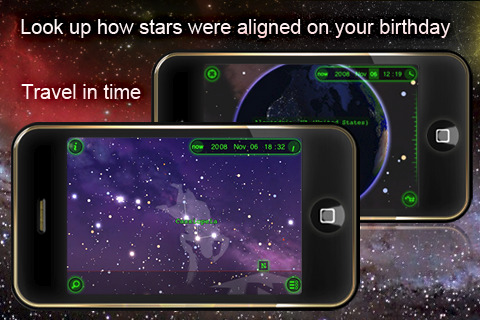
TIME MACHINE: tap the clock icon and scroll the time slider to watch the sky tonight or lets say two years from now. Travel in time and observe night sky on your birthday, be a part of astronomical events like eclipses and meteor showers.
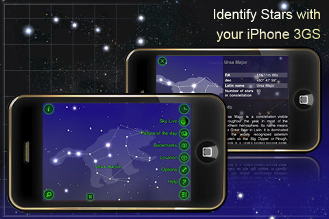
SKY LIVE Window: open up the new window by tapping the moon-shaped button to see moon phases, elevation, and rising data for the Sun, Venus, Mercury, Jupiter, and Saturn.
PICTURE of the DAY: a push notification will appear on the Star Walk icon to tell you there is a new picture. Tap the right hand corner menu button, select glowing "Picture of the Day" button and a list of pictures will open in front of you. To learn more about the pictures tap the -i- icon on the top right hand corner.
BOOKMARKS: save a reminder of beautiful night sky observations, bookmark it on your iPhone and send it to your friends via e-mail.
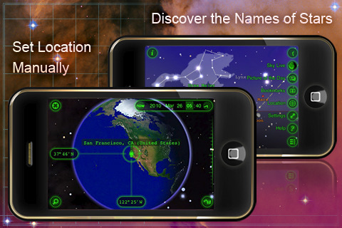
VIEW from the EARTH: Automatic and manual selection of locations on a 3D globe.
MOON PHASES: select the SKY LIVE window and see the moon phases for several days. Change dates on the top to see the moon phases for the past or for the future. Or zoom in the image of Moon and scroll the time slider.
Wikipedia LINKS: select one celestial body and tap the - i - icon to activate the magnifier and read main information about it. To know more tap the Wiki icon at the bottom of the table and the Wikipedia page will open up.
SETTINGS: with the settings you can modify user preferences like you can change the screen to night mode, select brightness of the stars (change stars magnitude with a slider), put sounds on or off, switch on or off the constellations images.
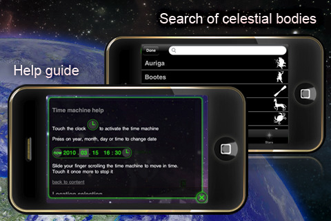
HELP GUIDE: the help tab includes some basic instruction on how to use time machine and location selection. FAQ section includes some common questions from our users and answers to them. For any doubts, suggestions or concerns contact us via support e-mail, Twitter or Facebook fan page.
What's New in This Release:
· Arabic translation
· BIG SCREEN - connect a second display to your iPhone or iPod and view the sky on it!
· Many bugs fixed
Like it? Share with your friends!
If you got an error while installing Themes, Software or Games, please, read FAQ.
Supported operating systems:
Apple iOS 10.x (iPad), Apple iOS 10.x (iPhone), Apple iOS 11.x (iPad), Apple iOS 12.x (iPad), Apple iOS 12.x (iPhone), Apple iOS 4.0.x (iPhone), Apple iOS 4.0.x (iPod Touch), Apple iOS 4.2.x (iPad), Apple iOS 4.2.x (iPhone), Apple iOS 4.2.x (iPod Touch), Apple iOS 4.3.x (iPad), Apple iOS 4.3.x (iPhone), Apple iOS 4.3.x (iPod Touch), Apple iOS 5.0 (iPad), Apple iOS 5.0 (iPhone), Apple iOS 5.0 (iPod Touch), Apple iOS 6.0 (iPad), Apple iOS 6.0 (iPhone), Apple iOS 6.0 (iPod Touch), Apple iOS 7.0 (iPad), Apple iOS 7.0 (iPhone), Apple iOS 7.0 (iPod Touch), Apple iOS 8.x (iPad), Apple iOS 8.x (iPhone), Apple iOS 8.x (iPod Touch), Apple iOS 9.x (iPad), Apple iOS 9.x (iPhone), Apple iOS 9.x (iPod Touch), Apple iPhone OS 3.1.x, Apple iPhone OS 3.1.x (iPod Touch), Apple iPhone OS 3.2.x (iPad)
Similar Software:
Planets for iPhone/iPad Planets is absolutely free in support of the International Year of Astronomy 2009. Over 1.2 million downloads so far!
Is that dot, a star or a planet? Answer questions like this with "Planets". Discover when you can see a certain planet, and where to look for it in relation to the stars
SkyView SkyView - Where will the Sun rise and set today? Is there a Full Moon tonight? Where is the constellation Orion? Am I looking at a bright star or a planet? What are some fun facts about these objects?
SkyView is a powerful and easy-to-use application that answers these questions and more
Solar Walk - Saturn Solar Walk - Saturn - This app is a lite version of the popular astronomy software Solar Walk. It lets you explore Saturn, the sixth planet from the Sun, as well as its moons: Mimas, Enceladus, Tethys, Dione, Rhea, Titan, Hyperion, and Iapetus, in 3D
The Night Sky for iPhone/iPad The Night Sky for iPhone/iPad - The Night Sky is a useful app that allows astronomy enthusiasts to quickly identify celestial bodies.
Simply point your iPhone, iPad or iPod touch to a star, constellation, planet or other object in the sky and the software will tell you its name
iMoon iMoon calculates the current moon phase and pictures it approximatively. Additional moon data (moon age, distance, constellation, visibility in percent, etc.) is displayed in real-time.
Via Fast Forward/Rewind (with adjustable time shift) you can view past and future moon phases.
What's New in This Release:
· Updated for iPad
Mars Envi Mars Envi - It's the best way to review decades worth of Mars missions, and to check out the latest happenings there
iCSC Clear Sky Chart iCSC Clear Sky Chart - iCSC downloads the Clear Sky Chart for your observing location. It's the astronomers forecast. It tells you when, in the next 48 hours, you might expect clear and dark skies.
What's New in This Release:
· Current site ID and name displayed in EnterSiteID page.
· Bug fixed in Connecticut sites list
Space Envi Space Envi - Space Envi is a great way to begin exploring Web-based space imagery.
From Astronomy Pictures of the Day, to the early space missions, to the latest pictures from Mars, Space Envi displays Web-based space photos the way you would expect on the iPhone: full screen, with multi-touch controls, in automated slide shows
SkySafari 3 Plus SkySafari 3 Plus - SkySafari Plus is a chart star app for all astronomy enthusiasts. It includes a comprehensive database of 2.5 million stars and 31,000 deep sky objects.
In addition, the application displays the Solar System's planets along with their moons, as well as 4,000 asteroids, comets and satellites
SkySafari 3 Pro SkySafari 3 Pro - SkySafari Pro is a chart star app for all astronomy enthusiasts. It includes a comprehensive database of 15.3 million stars, 740,000 galaxies down to 18th magnitude, and over 580,000 solar system objects.
In addition, the application displays the Solar System's planets along with their moons, as well as every comet and asteroid ever discovered
Other Software by developer «VITO Technology»:
Map of Pennsylvania (US State) Map of Pennsylvania (US State) - A map of the Pennsylvania by VITO Technology. Good for intercity travels with SmartMap.
SmartMap is a mobile device application which uses vector and raster maps. It is compatible with any NMEA protocol GPS receiver (Compact Flash socket, serial port, BlueTooth or sleeve)
Map of South Carolina (US State) Map of South Carolina (US State) - A map of the South Carolina by VITO Technology. Good for intercity travels with SmartMap.
SmartMap is a mobile device application which uses vector and raster maps. It is compatible with any NMEA protocol GPS receiver (Compact Flash socket, serial port, BlueTooth or sleeve)
Map of Singapore A map of Singapore. The map is accompanied by a short text description
VITO FindMe VITO FindMe is a free GPS utility for Pocket PC Phone Edition that will help your friends immediately find your whereabouts just by sending an SMS.
VITO FindMe features
Your friends want to know your whereabouts
After installing VITO FindMe you will need to set a codeword and give it to your friends for them to find your location
Map of Oman Map of Oman - A map of Oman, divided into 8 smaller territories for the ease of use.
MUSANDAM
AL BATINAH
AL ZANIRAH
MASQAT
AD DAKHILIYAH
ASH SHARQIYAH
AL WUSTA
ZUFAR
Good for intercity travels with SmartMap
Map of Nevada (US State) Map of Nevada (US State) - A map of the Nevada by VITO Technology. Good for intercity travels with SmartMap.
SmartMap is a mobile device application which uses vector and raster maps. It is compatible with any NMEA protocol GPS receiver (Compact Flash socket, serial port, BlueTooth or sleeve)
Map of New Mexico (US State) Map of New Mexico (US State) - A map of the New Mexico by VITO Technology. Good for intercity travels with SmartMap.
SmartMap is a mobile device application which uses vector and raster maps. It is compatible with any NMEA protocol GPS receiver (Compact Flash socket, serial port, BlueTooth or sleeve)
VITO Weather VITO Weather - Weather is a Windows Mobile software for getting weather forecast right on your mobile device. It has intuitive and finger-friendly interface.
Weather was designed specially for Winterface - next generation Windows Mobile shell. When added to Winterface there appears a special Weather icon among other status icons with “live” info
Map of Philippines Map of Philippines - A map of Philippines. Good for intercity travels with SmartMap.
Layers include:
Towns
Settlements
Airports
Roads
Railroads
Rivers
Inland water
Administrative borders
International borders
Trees
Map scale is 1:1 million.
Good for use with any version of SmartMap
Map of Syria Map of Syria - A map of Syria, divided into 12 smaller territories for the ease of use. Good for intercity travels with SmartMap. Layers include:
Towns
Settlements
Airports
Roads
Railroads
Rivers
Inland water
Administrative borders
International borders
Trees
Map scale is 1:1 million


")
")


")
")


