Platforms: iPhone, iPad, iPod Touch, Apple iPhone OS
Categories: Travel & Navigation
Upload date: 24 Mar 11
Developer: Tenereillo
License: Freeware
Downloads: 524
Trapster is a free application that alerts you as you approach police speed traps, red light cameras or speed cameras. Also, it provides turn by turn directions, local search, and My Trips trip recorder all from within Trapster!
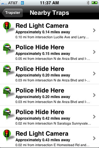
· World's most complete and up to date speed trap and camera database with 500,000 traps reported.
· Real time alerts for police radar/laser speed traps, mobile speed cameras, and checkpoints. These traps automatically expire because they are not permanent.
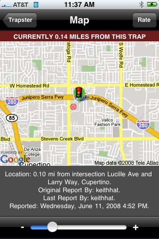
· Alerts for red light cameras, fixed speed cameras, and known speed trap locations.
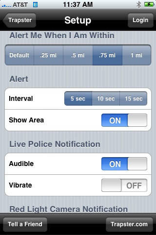
· Virtual Radar dynamic alert area narrows and elongates based on your speed and direction of travel.
· As of iPhone 3.0, Trapster uses the native iPhone MapKit with Google maps for the best possible mapping experience on the iPhone.
· As you approach a reported trap a spoken voice alert will play, and on-screen icons will animate, according to the type of trap (for example "Live Police!").
· Report traps that you see by simply tapping the screen.
· Rate traps submitted by other users (agree/disagree).
· The system learns the credibility of users over time based on how many other users agree with the traps they report.
· "Push" notification starts the app via the Trapster real time live police report text messaging system.
· My Trips feature
· This feature broadens the scope of the app beyond speed traps, to a useful and fun travel tool.
· Record your trips, see them in the app, and on the Web.
· Share your trips with your friends and family. They can watch your progress in real time from any computer, or iPhone.
· Geo-tag your trip with photos and notes about interesting things you see.
· Privacy: Keep your trip totally private, share it with the world, or share it only with certain people you choose.
· Facebook and Twitter integration
· Now Trapster can post the traps you report, and the trips you record, directly to your Facebook wall or Twitter account. Uses Facebook Connect and Twitter OAuth so that you never need to give your private Facebook or Twitter account credentials to Trapster.
What's New in This Release:
· Bug fix for iOS 4.3 where GPS position does not properly center. You must update to this version for the app to function correctly in iOS 4.3.
Like it? Share with your friends!
If you got an error while installing Themes, Software or Games, please, read FAQ.
Supported operating systems:
Apple iOS 10.x (iPad), Apple iOS 10.x (iPhone), Apple iOS 11.x (iPad), Apple iOS 12.x (iPad), Apple iOS 12.x (iPhone), Apple iOS 4.0.x (iPhone), Apple iOS 4.0.x (iPod Touch), Apple iOS 4.2.x (iPad), Apple iOS 4.2.x (iPhone), Apple iOS 4.2.x (iPod Touch), Apple iOS 4.3.x (iPad), Apple iOS 4.3.x (iPhone), Apple iOS 4.3.x (iPod Touch), Apple iOS 5.0 (iPad), Apple iOS 5.0 (iPhone), Apple iOS 5.0 (iPod Touch), Apple iOS 6.0 (iPad), Apple iOS 6.0 (iPhone), Apple iOS 6.0 (iPod Touch), Apple iOS 7.0 (iPad), Apple iOS 7.0 (iPhone), Apple iOS 7.0 (iPod Touch), Apple iOS 8.x (iPad), Apple iOS 8.x (iPhone), Apple iOS 8.x (iPod Touch), Apple iOS 9.x (iPad), Apple iOS 9.x (iPhone), Apple iOS 9.x (iPod Touch), Apple iPhone OS 3.1.x, Apple iPhone OS 3.1.x (iPod Touch), Apple iPhone OS 3.2.x (iPad)
Similar Software:
Marine : Cote d'Azur - GPS Map Navigator Marine : Cote d'Azur - GPS Map Navigator - FlytoMap provides complete, quick and easy to use map applications for navigation for iPhone. Continues in the tradition of offering depth of information and functionality across expected places all over the world, exploring the map you get maximum details obtaining detailed information of every object on the map
Garmin Tracker (iPhone) Garmin Tracker (iPhone) - Brought to you by the worldwide leader in GPS, Garmin Tracker — combined with a GPS-enabled Garmin tracking device (purchase required) — lets you track what’s important while on the go.
Garmin Tracker is a free, unique application that'll help keep tabs on whatever's important to you
Liverpool Map Offline Liverpool Map Offline - This will be perfect when you are traveling and you don't have internet connection. This Offline Maps is not a replacement of Google Maps. It is used when you don't have internet connection and want to use maps
Baxter State Park - GPS Map Navigator Baxter State Park - GPS Map Navigator - Continues in the tradition of offering depth of information and functionality across expected places all over the world, exploring the map you get maximum details obtaining detailed information of each object on the map
Las Vegas GPS Guide The only thing we do, help you to move freely as an alien, by "Offline" & "GPS"
Shenandoah National Park - GPS Map Navigator Shenandoah National Park - GPS Map Navigator - Continues in the tradition of offering depth of information and functionality across expected places all over the world, exploring the map you get maximum details obtaining detailed information of each object on the map
Sygic Canada: GPS Navigation Sygic Canada: GPS Navigation - Sygic is a voice-guided, turn-by-turn GPS navigator for iPhone and iPad. The app uses TomTom maps, which are downloaded to your mobile device and can be used without an internet connection.
After selecting your destination, Sygic will present you with several different routes, so you can choose the one that suits you best
Marine: Porto Rico & Navassa Island - GPS Map Navigator Marine: Porto Rico & Navassa Island - GPS Map Navigator - FlytoMap provides complete, quick and easy to use map applications for navigation for iPhone. Continues in the tradition of offering depth of information and functionality across expected places all over the world, exploring the map you get maximum details obtaining detailed information of every object on the map
Monti Sibillini National Park - GPS Map Navigator Monti Sibillini National Park - GPS Map Navigator - FlytoMap provides complete, quick and easy to use map applications for navigation for iPhone. Continues in the tradition of offering depth of information and functionality across expected places all over the world, exploring the map you get maximum details obtaining detailed information of every object on the map
Hohe Tauern National Park - GPS Map Navigator Hohe Tauern National Park - GPS Map Navigator - FlytoMap provides complete, quick and easy to use map applications for navigation for iPhone. Continues in the tradition of offering depth of information and functionality across expected places all over the world, exploring the map you get maximum details obtaining detailed information of every object on the map
Other Software by developer «Tenereillo»:
Trapster Trapster - Your GPS enabled BlackBerry device alerts you as you approach police speed traps
Trapster (Java) Trapster is a free service that allows users to share the location of police speed traps using their mobile phones. The system uses the phone's GPS capabilities and the Internet to instantly alert other users as they approach the reported trap.
When you see a trap, report it by pressing a button on your phone, or calling a toll free number


")
")


")