CacheTrack is a Java application for S60 mobile phones that reads files in the Geocaching.com-GPX-format and helps to find geocaches.
CacheTrack is a free application. You just have to visit a web page containing the latest about CacheTrack on your phone to unlock the application for 24 hours.
· Open GPX files which are compatible with Geocaching.com
· record of your tour
· export the recorded tour as a KML file to be viewed with Google Earth
· export waypoints as "Landmarks" e.g. to view them on Nokia Maps or use the "Navigate to" function of your phone
· create new waypoints
· waypoint projection
· view images referenced by the cache description
· view cache logs
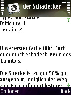
· view cache description
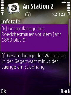
· view cache hints
· can use internal or external GPS receivers
· automate the creation of waypoints based on instructions found in the cache description by the use of a so called "Solver"
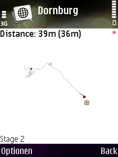
· view an Google Maps image showing the current waypoints
What's New in This Release:
· Can now read new and old Geocaching.com GPX files
Like it? Share with your friends!
Requirements:· Symbian S60 3rd/5th Edition
Supported operating systems:
Java ME, Java Nokia 240x320, Java SE 240x320
Similar Software:
FON Access Points for Macao FON Access Points for Macao - FON offers you a new Points of Interest service (POIs). This allows you to download FONspots directly to your navigation device.
What does that mean? You can download a Points of Interest file directly to your navigation device
GpsMid Croatia GpsMid is a free, fully offline, vector based map application for your mobile phone. It displays your current position on a zoomable map and can be used to search for and navigate to roads or points of interest of your liking. As all data is stored in a compact binary format on your mobile phone you will incur no charges for extra data downloads
MokBee Maps MokBee Maps - the coolest and newest application designed to run on Java enabled mobile phones, and will put the world literally in your pocket.
The World on your phone! You'll feel like Superman or Wonder Woman as you pan and zoom around the planet, maps are supplied by TerraPages
TrackMe GPS Tracker and Alert Mobile application helps users to update their mobile location to friends, family & location managing server. The primary purpose of this app is to provide real time tracking, store tracks of your trips and set Geo-fence
BT747 MTK GPS Datalogger Device Control BT747 MTK GPS Datalogger Device Control - i-Blue 747 / i-Blue 757 / Qstarz BT-Q1000 / i.Trek Z1 / Konet BGL-32 / Holux M-241 / ... control SW (for PalmOS, WinCe (PPC), Java platform, Windows, Linux, and MacOS). Compatible with most MTK GPS based loggers
Tracking - Transportlines Tracking - Transportlines - Live GPS tracking system - Sign up at www.transportlines.com first to get your account - Free Allows for multiple users under your own account. Keeps, speed, direction, time, address of each reported position. Various reports available. Useful for hikers, cyclists, yachting, keeping track of your employees etc.
FON Access Points for Senegal FON Access Points for Senegal - FON offers you a new Points of Interest service (POIs). This allows you to download FONspots directly to your navigation device.
What does that mean? You can download a Points of Interest file directly to your navigation device
ED Fonecta Fonecta provides you with millions of local contacts and services - for free! Let the GPS-aided search help you find nearest restaurants, hotels, or other local businesses. Integrated maps with directions will take you to your destination
GPSed (Java) GPSed (Java) - Want to store the most exciting trips in your life? Track trips from your mobile device, store them in an online archive and trace the tracks on Google maps.
· Get Trip Computer analogous to GPS devices and Trip Sharing Tool in one app.
· Record tracks of your trips anywhere on the Earth
FON Access Points for Palau FON Access Points for Palau - FON offers you a new Points of Interest service (POIs). This allows you to download FONspots directly to your navigation device.
What does that mean? You can download a Points of Interest file directly to your navigation device
Other Software by developer «Bjoern Quentin»:
WPAverager WPAverager - WPAverager helps you to create more exact landmarks / waypoints with your mobile device.
You just set how many coordinates it should record and how many of the best ones should be used to average the final location. Then you can save it to the landmarks store. That's it.
You should experiment with the values to get the best results
MMS Effects Type in your message and convert it into an animated multimedia message. Choose from seven effects - no more boring text messages
CacheTrack CacheTrack- is a Java application for S60 mobile phones that reads files in the Geocaching.com-GPX-format and helps to find geocaches.
CacheTrack is a free application. You just have to visit a web page containing the latest about CacheTrack on your phone to unlock the application for 24 hours.
· Open GPX files which are compatible with Geocaching
MTKTuner A little utility for your J2ME phone to turn WAAS/EGNOS on/off on your MTK powered bluetooth GPS receiver (e.g. the Holux M-1000)


")


