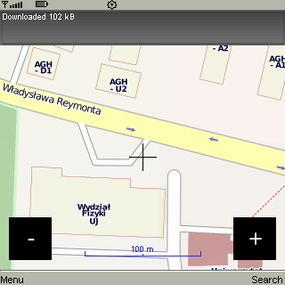
CloudGPS is Java ME mapping application using OpenStreetMap data and CloudMade services to provide.
· view different maps with panning and zooming
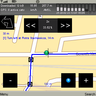
· use GPS (internal, bluetooth) to show current position
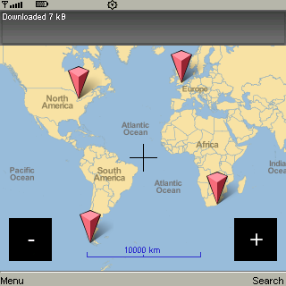
· find objects by name
· find route between two points
· route to destination using turn-by-turn instructions
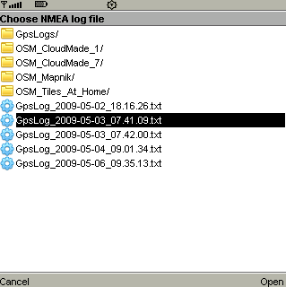
· record and replay NMEA
· caching tiles without artificial limits
Like it? Share with your friends!
Requirements:· MIDP 2.0, CLDC 1.0
Supported operating systems:
Java ME, Java Nokia 240x320, Java SE 240x320
Similar Software:
GpsMid Italy North GpsMid Italy North is a free, fully offline, vector based map application for your mobile phone. It displays your current position on a zoomable map and can be used to search for and navigate to roads or points of interest of your liking. As all data is stored in a compact binary format on your mobile phone you will incur no charges for extra data downloads
FON Access Points for Lithuania FON Access Points for Lithuania - FON offers you a new Points of Interest service (POIs). This allows you to download FONspots directly to your navigation device.
What does that mean? You can download a Points of Interest file directly to your navigation device
LoroDux alpha LoroDux alpha - "Loro" is the Spanish word for parrot. "Dux" is the Latin word for guide. LoroDux shall be the speaking guide on your shoulder.
LoroDux is an OSM and Java based navigation software for mobile devices for blind and visually impaired persons.
· Import POIs and crossings from OpenStreetMap
FON Access Points for Martinique FON Access Points for Martinique - FON offers you a new Points of Interest service (POIs). This allows you to download FONspots directly to your navigation device.
What does that mean? You can download a Points of Interest file directly to your navigation device
GpsMid Italy, Central GpsMid Italy, Central is a free, fully offline, vector based map application for your mobile phone. It displays your current position on a zoomable map and can be used to search for and navigate to roads or points of interest of your liking. As all data is stored in a compact binary format on your mobile phone you will incur no charges for extra data downloads
MTKTuner A little utility for your J2ME phone to turn WAAS/EGNOS on/off on your MTK powered bluetooth GPS receiver (e.g. the Holux M-1000)
GpsMid Armenia GpsMid Armenia is a free, fully offline, vector based map application for your mobile phone. It displays your current position on a zoomable map and can be used to search for and navigate to roads or points of interest of your liking. As all data is stored in a compact binary format on your mobile phone you will incur no charges for extra data downloads
eGPSTrack eGPSTrack is a GPS tracking application for mobile devices supporting J2ME connected with a Bluetooth GPS receiver. It isn't a navigator, the purpose is to be a positioning tool to be used in mountain to know where you are in each moment and to store the route that you are doing. Specially used for trekking, hiking and bike routes
GpsMid Canada, British Columbia GpsMid Canada, British Columbia is a free, fully offline, vector based map application for your mobile phone. It displays your current position on a zoomable map and can be used to search for and navigate to roads or points of interest of your liking. As all data is stored in a compact binary format on your mobile phone you will incur no charges for extra data downloads
GpsMid Australia, Victoria GpsMid Australia (Victoria) is a free, fully offline, vector based map application for your mobile phone. It displays your current position on a zoomable map and can be used to search for and navigate to roads or points of interest of your liking. As all data is stored in a compact binary format on your mobile phone you will incur no charges for extra data downloads
Other Software by developer «Damian Waradzyn»:
not found
Comments on CloudGPS:
Comments not found
If you noted an error or download link is broken, please, report it via this page or use comments.
Please, select device to check if CloudGPS supports it