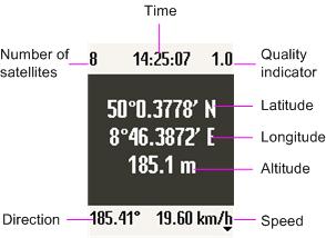
The GPSViewer shows the time, the current location, the speed, and the moving direction on the display of the mobile phone and runs on all phones, which at least support CLDC 1.0 and MIDP 2.0 and which allow access to Bluetooth (JSR 82) or the serial interface (data cable). That applies to nearly all current mobile phone models. Alternatively an integrated GPS receiver can be used if it can be accessed using JSR 179.
GPS receivers with Bluetooth or serial interface are supported, which provide the NMEA 0183 sentences GGA and VTG or RMC. That nearly all at the market available might be.
In the connection mode "Network/Internal" the Location API (JSR 179) is used. In this case no external GPS receiver is needed. In this case the location is determined by the GPS receiver or by the network provider. This functionality is obviously supported however in Germany so far by no provider.
GPSViewer is Freeware.
Usage
- Start GPSViewer.
- If necessary change the desired connection mode in the menu "Options". On Bluetooth capable mobile phones Bluetooth is preset, otherwise the data cable. In addition with selection of the data cable the Baud rate can be changed. The NMEA default value of 4800 Bit/s is preset. If needed, the automatic or manual altitude correction can be activated. The menu can be reached by a function key. Since the display is used in full-screen mode, on many phones is no mark for the active function key.
- The indication of the speed can take place in km/h or knots. The signal quality is the better, the smaller the value is.
- The indication takes place in blue, if no connection to the GPS receiver exists and red, if the GPS data are invalid (no free view to satellites).
What's New in This Release:
· Workaround for Sonim devices et al.
What's New in 2.6.1:
· Manual altitude correction for internal GPS receivers, Bluetooth URL editable.
Like it? Share with your friends!
Requirements:· CLDC 1.0
· MIDP 2.0
Supported operating systems:
Java ME, Java Nokia 240x320, Java SE 240x320
Similar Software:
FON Access Points for Slovenia FON Access Points for Slovenia - FON offers you a new Points of Interest service (POIs). This allows you to download FONspots directly to your navigation device.
What does that mean? You can download a Points of Interest file directly to your navigation device
FON Access Points for French Guiana FON Access Points for French Guiana - FON offers you a new Points of Interest service (POIs). This allows you to download FONspots directly to your navigation device.
What does that mean? You can download a Points of Interest file directly to your navigation device
GpsMid Greater London GpsMid is a free, fully offline, vector based map application for your mobile phone. It displays your current position on a zoomable map and can be used to search for and navigate to roads or points of interest of your liking. As all data is stored in a compact binary format on your mobile phone you will incur no charges for extra data downloads
GpsMid Morocco GpsMid is a free, fully offline, vector based map application for your mobile phone. It displays your current position on a zoomable map and can be used to search for and navigate to roads or points of interest of your liking. As all data is stored in a compact binary format on your mobile phone you will incur no charges for extra data downloads
GpsMid Tunisia GpsMid is a free, fully offline, vector based map application for your mobile phone. It displays your current position on a zoomable map and can be used to search for and navigate to roads or points of interest of your liking. As all data is stored in a compact binary format on your mobile phone you will incur no charges for extra data downloads
FON Access Points for Singapore FON Access Points for Singapore - FON offers you a new Points of Interest service (POIs). This allows you to download FONspots directly to your navigation device.
What does that mean? You can download a Points of Interest file directly to your navigation device
FON Access Points for Nicaragua FON Access Points for Nicaragua - FON offers you a new Points of Interest service (POIs). This allows you to download FONspots directly to your navigation device.
What does that mean? You can download a Points of Interest file directly to your navigation device
FON Access Points for Macedonia FON Access Points - FON offers you a new Points of Interest service (POIs). This allows you to download FONspots directly to your navigation device.
What does that mean? You can download a Points of Interest file directly to your navigation device
GpsMid Canada, Ontario GpsMid Canada, Ontario is a free, fully offline, vector based map application for your mobile phone. It displays your current position on a zoomable map and can be used to search for and navigate to roads or points of interest of your liking. As all data is stored in a compact binary format on your mobile phone you will incur no charges for extra data downloads
Other Software by developer «Andreas Kardos»:
LocViewer LocViewer loads - map sections according to the current position from a Web service from the Internet and indicates the position on the display of the mobile phone. As data source e.g. road maps or satellite photos can be selected. In addition the speed and the moving direction are indicated. The map sections can be panned and zoomed
Wayviewer Wayviewer - offers navigation in Europe and North America without fees, subscriptions, and on-line costs. The route must be computed before departure on a PC or a Notebook. For it a MAP&GUIDE derivate, e.g. ADAC TourPlaner or MOTORRAD TourPlaner, or Microsoft MapPoint version 2002 and above is used
LocViewer Pro LocViewer loads map sections according to the current position from a Web service from the Internet and indicates the position on the display of the mobile phone. Pro version adds import/export of waypoints, sending of the current position by SMS, etc
POIAlert POIAlert indicates so called POIs (Points of Interest) by voice and display output. A POI can be any point with known GPS coordinates (danger place, restaurant, gas station etc.).
POI data can be loaded e.g. from several Internet sources. At present especially red light and speed cameras are supported