|
Map My Tracks - Map My Tracks turns your mobile phone into your personal training device that tracks your activities in real-time to share with others online. Map My Tracks is great for bringing a new insight into your sporting activity, it provides a competitive edge and makes training fun. Map My Tracks let your friends, competitors or parents know where you are right now.
It's ideal for tracking activities like sailing, cycling, running, canoeing, skiing, walking, windsurfing, orienteering, mountaineering, horse riding, hang gliding, gliding, snowboarding, paragliding, hot air ballooning or just for fun to show your friends where you are right now.
Map My Tracks is all about training smarter and improving sporting performance. It’s about sharing your sporting passion with the others in real-time. It’s about making training fun.
What is Map My Tracks?
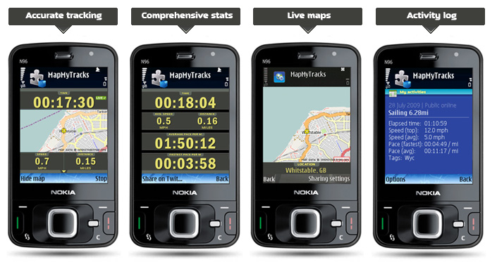
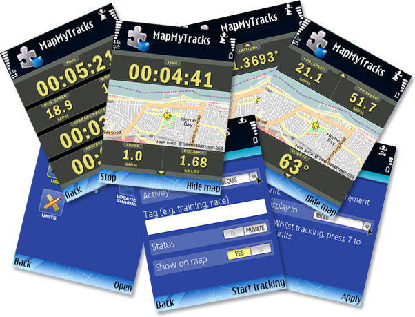
Map My Tracks turns your mobile phone into your personal real-time GPS tracking device. Using a mobile phone with built-in GPS or an external GPS receiver you can map and track your location in real-time. Map My Tracks brings a new insight into your sporting activity, provides a competitive edge and makes training fun. Map My Tracks let your friends, competitors or parents know where you are right now.
It’s ideal for tracking activities like sailing, cycling, running, canoeing, skiing, walking, windsurfing, orienteering, mountaineering, horse riding, hang gliding, gliding, snowboarding, paragliding, hot air ballooning or just for fun to show your friends where you are right now.
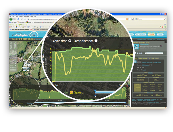
Replay, analyse and understand your performance
Map My Tracks uploads your GPS track data directly to your personal activity log on the web. Tracks can be made private for your own use or left for all to see.
With Map My Tracks you can:
- Track your progress over land, sea or air in real-time using just your mobile phone
- Allow friends, training partners, coaches, spectators or parents to follow your progress live
- Gain a competitive advantage. Replay, analyse and understand your performance.
- Automatically upload track data to your Map My Tracks activity log on the web – no cables needed
- Track your race with Map My Tracks and discover where your race was won or lost
- Replay your tracks overlayed on street or satellite maps
- Analyse distance, top speed, average speed, direction, and show your current location
- Discover new tracks or training routes around the World
- Share and review tracks by others
- Compare your performance against other competitors
- Share your location on Twitter and FriendFeed
Sync activities to your online activity log for analysis
|
Similar Software:
|
 | FON Access Points for Philippines
FON Access Points for Philippines - FON offers you a new Points of Interest service (POIs). This allows you to download FONspots directly to your navigation device.
What does that mean? You can download a Points of Interest file directly to your navigation device |  | MobileNumberLocator_Version4_MIDP2.0
Go to internet4mobile |  | GPS Watch - Plus
GPS Watch - Plus - GPS Watch is a powerful yet simple J2ME application that transforms your Mobile Phone and Bluetooth GPS into a professional Global Position Tracking System. GPS Watch integrates with www.trackut |  | GpsMid Albania
GpsMid Albania is a free, fully offline, vector based map application for your mobile phone. It displays your current position on a zoomable map and can be used to search for and navigate to roads or points of interest of your liking. As all data is stored in a compact binary format on your mobile phone you will incur no charges for extra data downloads |  | GpsMid Thailand
GpsMid is a free, fully offline, vector based map application for your mobile phone. It displays your current position on a zoomable map and can be used to search for and navigate to roads or points of interest of your liking. As all data is stored in a compact binary format on your mobile phone you will incur no charges for extra data downloads |
|
 | GpsMid Bahrain
GpsMid is a free, fully offline, vector based map application for your mobile phone. It displays your current position on a zoomable map and can be used to search for and navigate to roads or points of interest of your liking. As all data is stored in a compact binary format on your mobile phone you will incur no charges for extra data downloads |  | GpsMid United Arab Emirates
GpsMid is a free, fully offline, vector based map application for your mobile phone. It displays your current position on a zoomable map and can be used to search for and navigate to roads or points of interest of your liking. As all data is stored in a compact binary format on your mobile phone you will incur no charges for extra data downloads |  | NavFun Pro
NavFun Pro - If this program does not install on your mobile, please try the 'unsigned' version. Browse with your mobile to http://www.funrungames.com/download/unsigned/navfunpro.jad
NavFun Pro is the ideal navigation/maps tool that gives you all the goodies of a full featured GPS receiver and Google Maps, Earth, Terrain |  | Mobile GMaps
Mobile GMaps is a FREE application that displays Google Maps, Yahoo! Maps, Windows Live Local (MSN Virtual Earth) and Ask.com Maps and satellite imagery on Symbian and Java J2ME-enabled mobile phones, PDAs and other devices |  | FON Access Points for El Salvador
FON Access Points for El Salvador - FON offers you a new Points of Interest service (POIs). This allows you to download FONspots directly to your navigation device.
What does that mean? You can download a Points of Interest file directly to your navigation device |
|
|


