Categories: Internet & Communications, Travel & Navigation
Upload date: 3 Jan 12
Developer:
License: Freeware
Downloads: 6680 File Size: 28 Kb
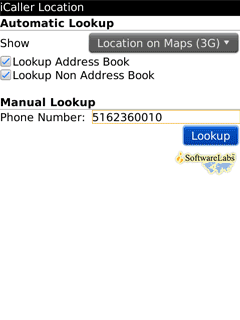
iCaller Location - iCaller Location (FKA i,Call Manager Ex) is a freeware application. iCallerLocation shows the area code, city, and state of the incoming caller (United States only) and pinpoints the location on the Maps. You will know where the call is coming from within the United States (will cover all cities in North America in the future). Mapping caller?s location is automatic with every incoming call. How does iCaller Location work? It?s very simple, on all incoming calls the application looks up the area code from the local database and displays city and state on the incoming call phone screen; or send city and state to Maps to pinpoint location automatically. The application uses actual and valid 443,435 NPA/NXX combinations in the North American Numbering Plan.
Like it? Share with your friends!
Supported operating systems:
Java ME, Java Nokia 240x320, Java SE 240x320
Similar Software:
WorldMap WorldMap - This application can display map-tiles. Colour map-tiles with 128x128 pixel for multiple resolutions (a multi-resolution pyramid) are used to allow fast zooming. This example displays a political world map. If you figure out the naming convention for the files, you will actually be able to create a JAR archive with your own map
GpsMid New Zealand GpsMid is a free, fully offline, vector based map application for your mobile phone. It displays your current position on a zoomable map and can be used to search for and navigate to roads or points of interest of your liking. As all data is stored in a compact binary format on your mobile phone you will incur no charges for extra data downloads
Google Maps Tip And Tricks This app provides you with step-by-step instructions on how to navigate google maps and explains the menu system
mEarth 3D Solution for Earth maps and satellite images
GpsMid Myanmar GpsMid Myanmar is a free, fully offline, vector based map application for your mobile phone. It displays your current position on a zoomable map and can be used to search for and navigate to roads or points of interest of your liking. As all data is stored in a compact binary format on your mobile phone you will incur no charges for extra data downloads
GpsMid Ethiopia GpsMid is a free, fully offline, vector based map application for your mobile phone. It displays your current position on a zoomable map and can be used to search for and navigate to roads or points of interest of your liking. As all data is stored in a compact binary format on your mobile phone you will incur no charges for extra data downloads
Gmaps A java j2me application for viewing google maps
GpsMid Belarus GpsMid is a free, fully offline, vector based map application for your mobile phone. It displays your current position on a zoomable map and can be used to search for and navigate to roads or points of interest of your liking. As all data is stored in a compact binary format on your mobile phone you will incur no charges for extra data downloads
Comments on iCaller Location:
elangovan:
i want caller information
Date: 22 Sep 12
parag:
good
Date: 16 Feb 13
If you noted an error or download link is broken, please, report it via this page or use comments.
Please, select device to check if iCaller Location supports it