CacheTrack is a Java application for S60 mobile phones that reads files in the Geocaching.com-GPX-format and helps to find geocaches.
CacheTrack is a free application. You just have to visit a web page containing the latest about CacheTrack on your phone to unlock the application for 24 hours.
· Open GPX files which are compatible with Geocaching.com
· record of your tour
· export the recorded tour as a KML file to be viewed with Google Earth
· export waypoints as "Landmarks" e.g. to view them on Nokia Maps or use the "Navigate to" function of your phone
· create new waypoints
· waypoint projection
· view images referenced by the cache description
· view cache logs
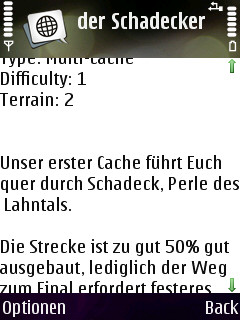
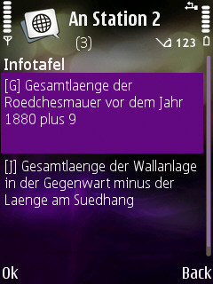
· view cache description
· view cache hints
· can use internal or external GPS receivers
· automate the creation of waypoints based on instructions found in the cache description by the use of a so called "Solver"
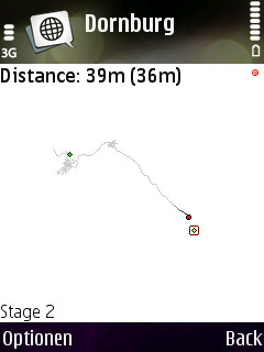
· view an Google Maps image showing the current waypoints
What's New in This Release:
· Can now read new and old Geocaching.com GPX files
Like it? Share with your friends!
Requirements:· Symbian S60 3rd/5th Edition
Supported operating systems:
Java ME, Java Nokia 240x320, Java SE 240x320
Similar Software:
GpsMid Midlands and Northern England GpsMid Midlands and Northern England is a free, fully offline, vector based map application for your mobile phone. It displays your current position on a zoomable map and can be used to search for and navigate to roads or points of interest of your liking
FON Access Points for Italy FON Access Points for Italy - FON offers you a new Points of Interest service (POIs). This allows you to download FONspots directly to your navigation device.
What does that mean? You can download a Points of Interest file directly to your navigation device
FON Access Points for Yemen FON Access Points for Yemen - FON offers you a new Points of Interest service (POIs). This allows you to download FONspots directly to your navigation device.
What does that mean? You can download a Points of Interest file directly to your navigation device
LoroDux alpha LoroDux alpha - "Loro" is the Spanish word for parrot. "Dux" is the Latin word for guide. LoroDux shall be the speaking guide on your shoulder.
LoroDux is an OSM and Java based navigation software for mobile devices for blind and visually impaired persons.
· Import POIs and crossings from OpenStreetMap
FON Access Points for Guernsey FON Access Points for Guernsey - FON offers you a new Points of Interest service (POIs). This allows you to download FONspots directly to your navigation device.
What does that mean? You can download a Points of Interest file directly to your navigation device
MokBee Maps MokBee Maps - the coolest and newest application designed to run on Java enabled mobile phones, and will put the world literally in your pocket.
The World on your phone! You'll feel like Superman or Wonder Woman as you pan and zoom around the planet, maps are supplied by TerraPages
j2me FindMyCar j2me FindMyCar - Innovative software for mobile devices that uses the GPS signal to show signs that allow to reach a geographic location.
Suitable for various uses (eg. find car parked in a parking area or in an unknown city, finding a person (who has sent their coordinates) in a lovely beach, in a fair, in another boat, find an area of sea fishing, etc..)
FON Access Points for Venezuela FON Access Points for Venezuela - FON offers you a new Points of Interest service (POIs). This allows you to download FONspots directly to your navigation device.
What does that mean? You can download a Points of Interest file directly to your navigation device
eGPSTrack eGPSTrack is a GPS tracking application for mobile devices supporting J2ME connected with a Bluetooth GPS receiver. It isn't a navigator, the purpose is to be a positioning tool to be used in mountain to know where you are in each moment and to store the route that you are doing. Specially used for trekking, hiking and bike routes
GpsMid Moscow GpsMid Moscow is a free, fully offline, vector based map application for your mobile phone. It displays your current position on a zoomable map and can be used to search for and navigate to roads or points of interest of your liking. As all data is stored in a compact binary format on your mobile phone you will incur no charges for extra data downloads
Other Software by developer «Bjoern Quentin»:
WPAverager WPAverager - WPAverager helps you to create more exact landmarks / waypoints with your mobile device.
You just set how many coordinates it should record and how many of the best ones should be used to average the final location. Then you can save it to the landmarks store. That's it.
You should experiment with the values to get the best results
MTKTuner A little utility for your J2ME phone to turn WAAS/EGNOS on/off on your MTK powered bluetooth GPS receiver (e.g. the Holux M-1000)
MMS Effects Type in your message and convert it into an animated multimedia message. Choose from seven effects - no more boring text messages
CacheTrack CacheTrack- is a Java application for S60 mobile phones that reads files in the Geocaching.com-GPX-format and helps to find geocaches.
CacheTrack is a free application. You just have to visit a web page containing the latest about CacheTrack on your phone to unlock the application for 24 hours.
· Open GPX files which are compatible with Geocaching