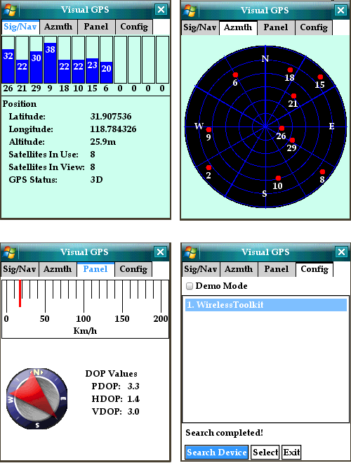
J2ME Bluetooth GPS Compass - Bluetooth GPS compass is a free J2ME application that displays GPS data graphically . features include satellite azimuth/elevation, GPS signal quality, analog gauges.
Like it? Share with your friends!
Supported operating systems:
Java ME, Java Nokia 240x320, Java SE 240x320
Similar Software:
Nokia N8 Fallymeter A small application that allows you to measure the distance to the epicenter of a thunderstorm, or the height of the cliff
Velox Internal GPS Velox Internal GPS - speedo clone which uses a Bluetooth or internal GPS receiver to display speed, calculate distances and record GPS tracks.
Velox supports recording GPS tracks and GPS tracks can be transferred to the PC via Bluetooth or uploaded to http://www.veloxgps.de.
Notice: not all compatible phones are supported (e.g
Offline Compass Free offline compass that has the ability to display the orientation and the current location in real time in degrees. This compass app has the ability to display direction in offline mode, and therefore requires no internet connection. In addition, this app also displays latitude and longitude, if your GPS is turned on (doesn’t require internet to be on)
Compass_Free Turn your phone into an accurate compass! Compass for mobile allows you to easily find your bearings by displaying a compass dial that points north. Simply choose the city you are in, point the phone in the direction of the sun, and the compass program will display the north pointing needle!
TMileage Pro V1.01 Your complete car management. Keep track of gas mileage, expenses, oil checks. Arrange your trips into categories. Export data via bluetooth or email. Imperial Units
compas Turn your phone into an accurate compass! Compass for mobile allows you to easily find your bearings by displaying a compass dial that points north. Simply choose the city you are in, point the phone in the direction of the sun, and the compass program will display the north pointing needle!
TMileage Pro Your complete car management. Keep track of gas mileage, expenses, oil checks. Arrange your trips into categories. Export data via bluetooth or email. Metric Units
SportyPal (Java) SportyPal is an easy to use intuitive application for your mobile device. You activate it when you start your running, cycling, walking, rollerblading or similar exercise. In two simple clicks it will start to log and map your position, movement, distance, tempo and calories burned
Comments on J2ME Bluetooth GPS Compass:
Comments not found
If you noted an error or download link is broken, please, report it via this page or use comments.
Please, select device to check if J2ME Bluetooth GPS Compass supports it


")


")