LocViewer loads - map sections according to the current position from a Web service from the Internet and indicates the position on the display of the mobile phone. As data source e.g. road maps or satellite photos can be selected. In addition the speed and the moving direction are indicated. The map sections can be panned and zoomed.
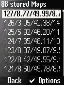
In order to reduce data traffic, the map sections are stored in the mobile phone. So a map section must be downloaded only once.
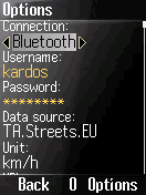
LocViewer runs on all phones which support at least CLDC 1.1 and MIDP 2.0 and allow access to Bluetooth (JSR 82) or the serial interface (data cable). That applies to nearly all current mobile phone models. Alternatively an integrated GPS receiver can be used if it can be accessed using JSR 179.
GPS receivers with Bluetooth or serial interface are supported, which provide the NMEA 0183 sentences GGA and VTG or RMC. That nearly all at the market available might be.
In the connection mode "Network/Internal" the Location API (JSR 179) is used. In this case no external GPS receiver is needed. In this case the location is determined by the GPS receiver or by the network provider. This functionality is obviously supported however in Germany so far by no provider.
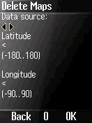
LocViewer can load maps from Google Maps, Yahoo! Maps from the specified data source and whose coordinates smaller or larger than the specified once will be deleted than.
What's New in This Release:
· Workaround for Sonim devices et al.
What's New in 2.1.2:
· Manual altitude correction for internal GPS receivers, Bluetooth URL editable.
Like it? Share with your friends!
Supported operating systems:
Java ME, Java Nokia 240x320, Java SE 240x320
MobileMap of Moscow MobileMap of Moscow - MobileMap is a vector map of Moscow with more than 3000 streets and metro stations.
The vector map of almost any city in Polish format can be easily converted to be used by this application. Because of limits on jar file size and small screen resolution, number of layers is restricted
Mobile GMaps Mobile GMaps is a FREE application that displays Google Maps, Yahoo! Maps, Windows Live Local (MSN Virtual Earth) and Ask.com Maps and satellite imagery on Symbian and Java J2ME-enabled mobile phones, PDAs and other devices
GpsMid Trinidad and Tobago GpsMid is a free, fully offline, vector based map application for your mobile phone. It displays your current position on a zoomable map and can be used to search for and navigate to roads or points of interest of your liking. As all data is stored in a compact binary format on your mobile phone you will incur no charges for extra data downloads
amAze (Sony Ericsson) AmAze is a first of its kind free navigation and local search service. It is free to download and use and it contains wide coverage of maps including aerial photo in Europe, North America, Australia and parts of Asia and Africa
mGeoNavigator mGeoNavigator This handy app is an intelligent touristic map-navigator of Bulgaria. It is useful to receive references if you have not a GPS device or if your GPS is not able to show maps
GpsMid Bay Area (California) GpsMid is a free, fully offline, vector based map application for your mobile phone. It displays your current position on a zoomable map and can be used to search for and navigate to roads or points of interest of your liking. As all data is stored in a compact binary format on your mobile phone you will incur no charges for extra data downloads
GpsMid Croatia GpsMid is a free, fully offline, vector based map application for your mobile phone. It displays your current position on a zoomable map and can be used to search for and navigate to roads or points of interest of your liking. As all data is stored in a compact binary format on your mobile phone you will incur no charges for extra data downloads
GpsMid Germany, Rhein-Main (Giessen - Heidelberg) GpsMid Germany, Rhein-Main (Giessen - Heidelberg) is a free, fully offline, vector based map application for your mobile phone. It displays your current position on a zoomable map and can be used to search for and navigate to roads or points of interest of your liking
GpsMid Zimbabwe GpsMid is a free, fully offline, vector based map application for your mobile phone. It displays your current position on a zoomable map and can be used to search for and navigate to roads or points of interest of your liking. As all data is stored in a compact binary format on your mobile phone you will incur no charges for extra data downloads
Other Software by developer «Andreas Kardos»:
Wayviewer Wayviewer - offers navigation in Europe and North America without fees, subscriptions, and on-line costs. The route must be computed before departure on a PC or a Notebook. For it a MAP&GUIDE derivate, e.g. ADAC TourPlaner or MOTORRAD TourPlaner, or Microsoft MapPoint version 2002 and above is used
POIAlert POIAlert indicates so called POIs (Points of Interest) by voice and display output. A POI can be any point with known GPS coordinates (danger place, restaurant, gas station etc.).
POI data can be loaded e.g. from several Internet sources. At present especially red light and speed cameras are supported
GPSViewer The GPSViewer shows the time, the current location, the speed, and the moving direction on the display of the mobile phone and runs on all phones, which at least support CLDC 1.0 and MIDP 2.0 and which allow access to Bluetooth (JSR 82) or the serial interface (data cable). That applies to nearly all current mobile phone models
LocViewer Pro LocViewer loads map sections according to the current position from a Web service from the Internet and indicates the position on the display of the mobile phone. Pro version adds import/export of waypoints, sending of the current position by SMS, etc


")

")

")


