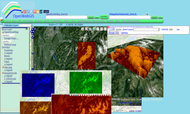
OpenWebGIS - OpenWebGIS is created for everyone who wishes to see and use a new free&open Geographic Information System(GIS). Please make your comments and suggestions. In this GIS you can use the extensive mathematical functionality to calculate and analyze your data. Using OpenWebGIS you will get a GIS at your disposal, it may be similar in functionality to some desktop GIS. Please support this project. The OpenWebGIS for Android has online and local version. In local version, you can use OpenWebGIS without having to connect to the server of OpenWebGIS and even without Internet connection. In local version, some functions do not work, but in future there will be the modification of these functions for the local version. The OpenWebGIS blog (http://openwebgisystem.blogspot.com/) provide a lot of information about possibilities for users' data operating. Full list of articles about OpenWebGIS: http://openwebgisystem.blogspot.com/2015/08/list-of-articles-about-openwebgis-in.html
Like it? Share with your friends!
Supported operating systems:
Google Android 10.x, Google Android 3.0, Google Android 3.1, Google Android 3.2, Google Android 4.0, Google Android 4.1, Google Android 4.2, Google Android 4.3, Google Android 4.4, Google Android 5.x, Google Android 6.x, Google Android 7.x, Google Android 8.x, Google Android 9.x
Similar Software:
Learn IPv6 v2 Learn IPv6 v2 - This tutorial has been designed to help beginners understand the basic concepts of IPv6 required to work with any TCP/IP based protocols. After completing this tutorial you will find yourself at a moderate level of expertise of IPv6 from where you can take yourself to next levels
Learn Computer Fundamentals Learn Computer Fundamentals - This tutorial has been prepared for the beginners as well as advanced learners who want to deal with computers. This tutorial is also very useful for the undergraduate students of computer science, engineering, business administration, management, science, commerce and arts where an introductory course on computers is a part of curriculum
What RGB? Simple application to check RGB values of an image
jQuery Reference Complete reference of all jQuery objects and methods, along with examples
Developers Best Practices Developers Best Practices - If you are working for software industry as a software engineer or a software developer, then I'm sure you are going to enjoy this tutorial. Try to relate the facts mentioned in the tutorial with your day-2-day life and find so many hidden facts, which are very obvious but we never gave our serious attention to them
Learn OOAD Learn OOAD - This tutorial has been designed to help beginners. After completing this tutorial, you will find yourself at a moderate level of expertise from where you can take yourself to next levels
AMF - Firefox Addon Apache Mobile Filter search engine helps mobile web developers to search mobile devices from user agent
Learn JSF Learn JSF - This tutorial has been prepared for the beginners to help them understand basic JSF programming. After completing this tutorial you will find yourself at a moderate level of expertise in JSF programming from where you can take yourself to next levels
Simply GData Simply GData is a light, simple, extensible library for accessing and modifying data available through Google Data APIs
Learn Node js Learn Node js - This tutorial is designed for software programmers who wants to learn the basics of Node.js and it's architectural concepts in simple and easy ways. This tutorial will give you enough understanding on components of Node.js with suitable examples. Node.js is a very powerful JavaScript based framework/platform built on Google Chrome's JavaScript V8 Engine
Comments on OpenWebGIS:
Comments not found
If you noted an error or download link is broken, please, report it via this page or use comments.
OpenWebGIS is compatible with your device Karbonn Titanium S20